
Lara, José Mariano Fernandez de (sold)

José Mariano Fernandez de Lara (1799 - 1892) was a Mexican publisher and printer active in Mexico City the middle to late 19th century. Fernandez de Lara was born in Mexico to a family of silversmiths. Eschewing the smithing trade, he began his printing business around 1822. At the time, printing in Mexico was undergoing a revolution. Prior to Mexican Independence (1821), printing was tightly controlled by the Spanish Crown, who insisted that only those with a Privilegio Real could operate presses. With newfound freedom of the press, and the need for a strong national identity, as well as the development of economical printing techniques like lithography, lead to an explosion of printing in the early 1820s. In 1821 alone the number of presses in Mexico City jumped from 8 to 15. His earliest work was crude, exhibiting little skill, but a passion for political canvassing for thought-leaders of the day, among them Fernández de Lizardi (1776 - 1827) and Gómez Farías (1781 - 1858). He soon became a master printer, employing the best Mexican engravers and typesetters of the generation. The Lara press prospered until the late 19h century, issuing books, atlases, posters, religious works, and more. Ultimately, the firm's business began to dry up as more advanced printing techniques led to greater competition. The firm closed its doors in 1878 and Lara himself died in 1892.
The only historic map that mentions Mezcal!
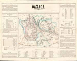
Oaxaca.
sold
- Digital Map Information
- Suitable for large format printing
- File Size: 23.73 MB
- File Type: ZIP / TIFF
- ICC color profile embedded
- Delivered instantly via download link
This is a rare 1858 Antonio Garcia y Cubas map of the state of Oaxaca, Mexico. Centered on Oaxaca City (Oajaca), coverages extends from the Guerrero border to Tehuantepec, then in a separate state, and from Veracruz to the Pacific. The map is divided into various subdistricts with considerable efforts to illustrate the region's mountainous interior - a considerable achievement for the time. Even the Pre-Columbian ruins at Mitla are noted. Only major roads are defined, underscoring just how remote and difficult to access many of these villages were - nonetheless most of the locations are noted with considerable accuracy. The map itself is surrounded by statistical tables. (more details)