
Larmat, Louis (sold)

Louis Larmat (19xx - xxxx) was a French publisher and cartographer active during the mid-20th century. Larmat published the world's first national wine atlas, his Atlas de la France Vinicole between 1941 and 1947. Divided into six volumes, each volume focused on a specific wine producing region. Volume one detailed wines from Bordeaux and subsequent volumes focused on Bourgogne, les côtes du Rhône, Champagne, les coteaux de la Loire, and the eaux-de-vie de France and cognac. Subsequent editions were published in 1949 and 1953, many of which were updated. It also appears that Larmat intended to produce a series of road maps meant for self-guided wine tours, the 'route des grand crus.' Only one of these is known to exist and focuses on the Bordeaux region. This map was not simply taken from the atlas focusing on Bordeaux. It was a new creation and includes the main roads and vignettes of several of the chateaux. Very little is known about Larmat's life and career apart from the Atlas de la France Vinicole. The Bibliothèque nationale de France notes that he was a publisher in Paris (éditeur Parisien) and provides two Parisian addresses. His earliest accredited publication dates to 1924 and was published in Nice, which suggests the Larmat may have begun his career there. He also published three separate maps later in his career: the general 'Carte de la France Vinicole' by Marcel Azema in 1945, the 'Carte du Vignoble Alsacien' by Robert Louis in 1949, and 'L'Algérie Vinicole' by Georges Lafosse in 1954.
The world's finest wines.
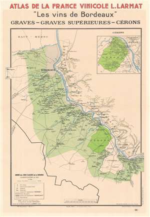
Atlas de France Vinicole L. Larmat 'Les Vins de Bordeaux' Graves - Graves Supérieures - Cérons.
sold
- Digital Map Information
- Suitable for large format printing
- File Size: 19.05 MB
- File Type: ZIP / TIFF
- ICC color profile embedded
- Delivered instantly via download link
This is a 1943 Louis Larmat wine map of the Bordeaux or Gironde region of France highlighting the graves, graves supérieures, and cérons wine regions. Light green highlights graves and graves supérieures production areas, while a bright green emphasizes the small cérons region. An inset in the upper right focuses on the cérons region. Wineries are labeled throughout. The region's major roads and railroads are also illustrated, along with its rivers. The Garonne, the region's major river, cuts through the map in a diagonal manner. (more details)
Illustrates France's Champagne wine region
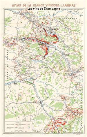
Les vins de Champagne
sold
- Digital Map Information
- Suitable for large format printing
- File Size: 33.84 MB
- File Type: ZIP / TIFF
- ICC color profile embedded
- Delivered instantly via download link
This is a 1944 Louis Larmat map of the Champagne wine region in France. Depicting from Soissons and Rethel to the Côte-d'Or and from Ste. Aulde in the Champagne region to the Departement de la Haute-Marne, thick pink lines surround the Champagne wine region, which is not a geographically contiguous area. Within the Champagne region, small towns and hamlets associated with the Champagne industry are labeled, and areas shaded red highlight vine-growers. Major cities in and around the Champagne region include Reims, Châlons-sur-Marne, and Troyes. Major roads and railroads are illustrated, along with rivers, swamps, and forested areas. In many parts of the world, in order for a wine to be labeled as Champagne unless it came from the Champagne wine region of France. (more details)
A region well-known for its popular champagnes.
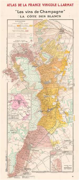
'Les vins de Champagne' La Côte des Blancs.
sold
- Digital Map Information
- Suitable for large format printing
- File Size: 31.55 MB
- File Type: ZIP / TIFF
- ICC color profile embedded
- Delivered instantly via download link
This is a 1944 Louis Larmat map of the Côte des Blancs. Depicting from Chouilly to Bergères-les-Vertus and from Montgrimaux to commune de Flavigny, the map focuses on the grape producers, the vignobles. Black dashed lines create the boundaries of the region's villages, including Oger, Le Mesnil-sur-Oger, Cuis, and Avize. Innumerable hamlets are identified in small italics, many of which are likely only known to local inhabitants. Roads and railroads are illustrated, as are wooded areas and parks. An inset in the lower-right details the area south of Bergères-les-Vertus. A second inset, along the left border, situates the present map within the Champagne region. The various colors used as shading throughout the map represent the ratings of the échelle des crus: blancs and the echelle des crus : blancs et noirs, quality rankings for Champagne region grapes. These ratings are based on a percentage scale out of 100, and when the system was instituted, each village, not each specific winery, was given a percentage out of 100. Here, five colors are used to mark the different percentages. Grand crus grapes, deemed to be the highest-quality grapes which received a 100% rating, were paid 100% of that a given year's set price. Thus the percentage assigned to the village determined the percentage any given grower would receive for their grapes. (more details)
Details the vine-growing areas of the Marne Valley in the Champagne region of France.
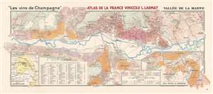
'Les vins de Champagne' Vallée de la Marne.
sold
- Digital Map Information
- Suitable for large format printing
- File Size: 33.7 MB
- File Type: ZIP / TIFF
- ICC color profile embedded
- Delivered instantly via download link
This is a 1944 Louis Larmat map of the Marne Valley (Vallée de la Marne) in the Champagne region of France. Depicting from Oeuilly to Tours-sur-Marne and from Romery and Fleury-la-Riviere to Moussy, the map focuses on the grape producers, the vignobles. Black dashed lines create the boundaries of the region's villages, which include Epernay, Champillon, Aÿ, and Avenay. Nearly two hundred lieuxdits (which roughly translates to hamlet and embodies the idea of a place name that only locals would know) are numerically identified throughout the region and correspond with an index on the bottom left. An inset on the lower right illustrates the region southwest of Epernay. On the lower left a second inset situates the present map within the Champagne region. The various colors represent the ratings of the échelle des crus: noirs, the way of ranking the quality of grape grown in a given location. These ratings are based on a percentage scale out of 100, and when the system was instituted, each village, not each specific winery, was given a percentage out of 100. Here, five colors are used to mark the different percentages. Grand crus grapes, deemed to be the highest-quality grapes which received a 100% rating, were paid 100% of that a given year's set price. Thus the percentage assigned to the village determined the percentage any given grower would receive for their grapes. (more details)
Includes Chateau-Thierry.
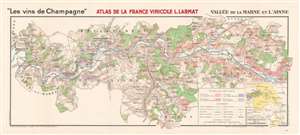
'Les vins de Champagne' Vallée de la Marne et l'Aisne.
sold
- Digital Map Information
- Suitable for large format printing
- File Size: 28.64 MB
- File Type: ZIP / TIFF
- ICC color profile embedded
- Delivered instantly via download link
This is a 1944 Louis Larmat map of the western Marne Valley and the Aisne Champagne vineyards in France. Depicting from the Département de la Seine-et-Marne to Damery and Fleury-la-Riviere and from Ste. Gemme to Verdon, the map focuses on the grape producers, the vignobles. Black dashed lines create the boundaries of the departments (France's regional divisions) and dotted lines separate the region's villages, including Baulne-en-Brie, Chateau-Thierry, Dormans, and Oeuilly. Roads and railroads are illustrated, as are wooded areas. An inset in the lower-right corner details situates the present map within the Champagne region. The various colors used as shading throughout the map represent the ratings of the échelle des crus, the way of ranking the quality of grape grown in a given location in the Champagne region. These ratings are based on a percentage scale out of 100, and when the system was instituted, each village, not each specific winery, was given a percentage out of 100. Here, five colors are used to mark the different percentages. Grand crus grapes, deemed to be the highest-quality grapes which received a 100% rating, were paid 100% of that a given year's set price. Thus the percentage assigned to the village determined the percentage any given grower would receive for their grapes. (more details)