
Laval, Antoine Jean de (sold)

Antoine Jean de Laval (1664 – 1728) was a French Jesuit priest and scientist active in the late 16th and early 17th century. Laval was a royal professor of hydrography and mathematics based in the city of Toulon. Laval is best known for his 1720 voyage along the Gulf Coast to triangulate the exact longitude of the Mouth of the Mississippi River. Laval never obtained his objective, in fact may never have seen the Mississippi River, but did publish an important account of the region in his 1728, Voyage de la Louisiane.
One of the earliest obtainable specific maps of the Gulf Coast.
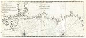
Carte de la Coste de la Louisiane depuis l'embouchure de la Riviere de Micissipi jusques à la Riviere de S. Martin.
sold
- Digital Map Information
- Suitable for large format printing
- Full resolution TIFF file
- ICC color profile embedded
- Delivered instantly via download link
An extremely rare and important 1728 Antoine Laval map of the Mississippi River Delta and the coast of Louisiana and Mississippi. The map covers from Lake Pontchartrain and Lake Maurepas eastward along the coast past the Delta of the Mississippi, Mobile bay, ... (more details)