
Lévy, Michel (sold)

Michel Lévy (1821 - May 4, 1875) was a French publisher and founder of the Michel Lévy Frères publishing house. Born in Phalsbourg in the Moselle to a bookseller (colporteur), he began selling books in Paris at the age of fifteen under the name Michel Lévy Frères. Although his brothers Kalmus (Calmann) and Nathan were sometimes involved in his business, Michel was the primary bookseller and later publisher. Initially, Lévy focused on works relating to the theater, but later expanded into literature, periodicals, and other fields. By the 1860s, Michel Lévy Frères was one of the major publishers in France, putting out works by the likes of Honoré de Balzac, Gustave Flaubert, and Victor Hugo. Michel Lévy was inducted into the Légion d'Honneur in 1873, but died unexpectedly two years later. Afterwards, his brother took charge of the firm, then renamed Calmann Lévy (sometimes as Calmann-Lévy), and it continued its success as a leading publisher in France. In 1893, Calmann turned over the business to his three sons, Georges, Paul, and Gaston, who ran it until the Second World War, when Gaston was interned by the Nazis and the publishing house was renamed Editions Balzac. After the war, the firm continued and still exists today as a subsidiary of Hachette.
The Bloodiest Day in U.S. Military History.
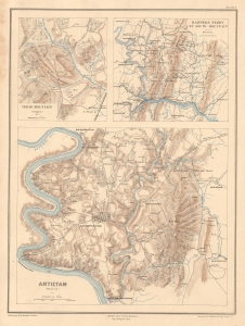
Cedar Mountain (Virginie). Harpers Ferry et South Mountain. Antietam (Maryland).
sold
- Digital Map Information
- Suitable for large format printing
- Full resolution TIFF file
- ICC color profile embedded
- Delivered instantly via download link
This is Ernest Dumas-Vorzet's map of the 1862 Civil War Battles of Cedar Mountain, Harpers Ferry, and Antietam, issued to illustrate the 1890 book Histoire de la Guerre Civile en Amérique. (more details)
Crucible of the Civil War.
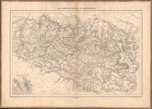
Les champs de bataille du Rappahannock.
sold
- Digital Map Information
- Suitable for large format printing
- File Size: 26.28 MB
- File Type: ZIP / TIFF
- ICC color profile embedded
- Delivered instantly via download link
This 1890 Dumas Vorzet map displays eastern Virginia south of the Rappahannock River, the site of several important battles in the U.S. Civil War. It appeared in the scarce 1890 atlas volume of the French edition of Philippe d'Orléans' Histoire de la Guerre Civile en Amérique. (more details)
Capturing the Crescent City.
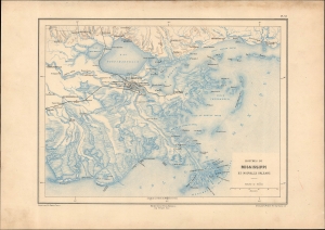
Bouches du Mississippi et Nouvelle Orleans.
sold
- Digital Map Information
- Suitable for large format printing
- File Size: 13.43 MB
- File Type: ZIP / TIFF
- ICC color profile embedded
- Delivered instantly via download link
A remarkable map of the Mississippi River Delta, New Orleans, and environs, prepared in 1890 by Ernest Dumas-Vorzet. It appeared in the scarce 1890 atlas volume of the French edition of Philippe d'Orléans' Histoire de la Guerre Civile en Amérique. (more details)
Emergence of 'the Grey Ghost'
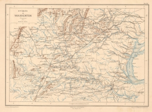
Environs de Warrenton (Virginie).
sold
- Digital Map Information
- Suitable for large format printing
- File Size: 7.95 MB
- File Type: ZIP / TIFF
- ICC color profile embedded
- Delivered instantly via download link
This is Ernest Dumas-Vorzet's 1890 map of Warrenton, Virginia and environs, prepared for his Histoire de la Guerre Civile en Amérique. It relates to the 1863 American Civil War (1861 - 1865) Warrenton Junction Raid, one of the first significant actions of 'the Gray Ghost', Confederate commander John S. Mosby and his eponymous Mosby’s Rangers. (more details)
A House Divided...
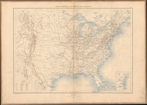
Carte générale du théâtre de la guerre.
sold
- Digital Map Information
- Suitable for large format printing
- Full resolution TIFF file
- ICC color profile embedded
- Delivered instantly via download link
This is Ernest Dumas-Vorzet's 1890 map of the United States, prepared for Histoire de la Guerre Civile en Amérique. It was the first map in the atlas volume accompanying the book. (more details)
An Imperiled Capital.
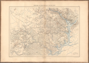
Environs de Washington et du Bull Run.
sold
- Digital Map Information
- Suitable for large format printing
- File Size: 21.94 MB
- File Type: ZIP / TIFF
- ICC color profile embedded
- Delivered instantly via download link
This is an 1890 Dumas Vorzet map of Washington, D.C., and its environs in eastern Virginia, the scene for multiple important battles during the American Civil War (1861 - 1865), issued as part of the scarce atlas volume of the French edition of Philippe d'Orléans' Histoire de la Guerre Civile en Amérique. (more details)