
Luffman, John (sold)

John Luffman (fl. c. 1776 - 1820) was an engraver, mapmaker and publisher, active in London during the late 18th and early 19th centuries. Though established as a bookseller and publisher, Luffman began his career as an engraver. His earliest cartographic work was a series of maps for two road 1776 books, Mostyn John Armstrong's An Actual Survey Of The Great Post-Roads Between London And Edinburgh and Taylor And Skinner's Survey And Maps Of The Roads Of North Britain, Or Scotland. Later, he issued A New Pocket Atlas And Geography Of England And Wales in 1803. Luffman built his business by quickly responding to political events with illustrative maps produced just as interest in particular regions waxed: for example his map of Napoleon's proposed naval invasion of England and his map of the island of Ceylon following its 1801 takeover by England.
Map showing the British takover of Ceylon in 1801.
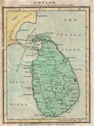
Ceylon. Ceded to Great Britain by the Treaty of Pease, 1801
sold
- Digital Map Information
- Suitable for large format printing
- Full resolution TIFF file
- ICC color profile embedded
- Delivered instantly via download link
This beautiful 1801 map by John Luffman marks an important moment in the history of Ceylon (Sri Lanka), as well as the history of France, the United Kingdom, and the Dutch (then 'Batavian') Republic. In 1795 the Portuguese controlled kingdoms that made up Ceylon ... (more details)