
MacDonald, John (sold)

John MacDonald (1759 - 1831) was a British naval officer active in the late 18th and early 19th centuries. John was the son of Flora MacDonald, a Jacobite heroine who sheltered the young Bonnie Prince Charles, the second Jacobite pretender to the throne of the British Isles. MacDonald entered the service of the British East India Company where he was commissioned as a captain in the Crops of Engineer, Bengal. By 1784 he has been assigned to British East India company trading post at Fort Marlborough, Bencoolen, Sumatra. There he married the widow Nancy Scott Bogle. He spent approximately sixteen years in Bencoolen wherein he surveyed much of the western coast of the island. He sent several missives to the Royal Society featuring observation on magnetic variations based on studies done at Bencoolen and St. Helena from 1794 - 1796. Back in England, c. 1800, he was elected a fellow of the Royal Society and elevated to Lieutenant-Colonel of the Royal Clan-Alpin regiment. Subsequently he was stationed in Ireland where he composed several volumes on military strategy. MacDonald seems to have returned to Bencoolen by 1808 when he was assigned to the post of Chief Engineer at Fort Marlborough. In 1818 or 1819 he returned to England settling in Exeter, where lived for twelve years until his death in 1831, he was 72. He is buried at Exeter Cathedral.
A hand drawn manuscript map - most likely the first accurate nautical chart of west Sumatra's Pepper Coast.
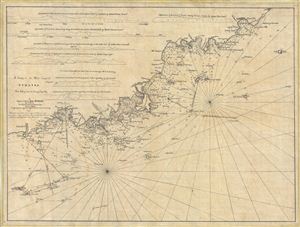
A Survey of the West Coast of Sumatra From Padang head to batang Capay Bay.
sold
- Digital Map Information
- Suitable for large format printing
- DPI: 300
- File Size: 13.45 MB
- File Type: ZIP / TIFF
- ICC color profile embedded
- Delivered instantly via download link
A remarkable discovery, this is a c. 1820 manuscript map of the western coasts of Sumatra (Indonesia) around the city of Pedang by Scottish sea captain John MacDonald. The map covers the west central Sumatra coastline from, roughly, Pedang (regional trading ... (more details)