
Martin, Alexandre (sold)

Alexandre Martin (17xx - 18xx) was a French writer, cartographer, and intellectual. Martin created a series of plans of Paris published between 1822 and 1827 by several different publishers. It appears that he also authored several books concerning history and geography.
Height of the Bourbon Restoration.
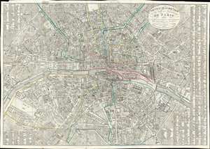
Nouveau Plan Routier de la Ville et Faubourgs de Paris Divisé en 12 Mairies municipales et subdivisé par quartier pour servir de guide aux Etrangers.
sold
- Digital Map Information
- Suitable for large format printing
- Full resolution TIFF file
- ICC color profile embedded
- Delivered instantly via download link
This is an 1823 Alexandre Martin city plan or map of Paris, France published at the height of the Bourbon Restoration. Centered on the Ile de la Cité and Notre Dame Cathedral, numerous important locations are identified, including the Louvre, the Jardin des Tuileries, the Avenue des Champs-Elysées, and the Champ de Mars. Hand coloring outlines the city's twelve mairies municipals and numbers identify forty-eight different neighborhoods, or quartiers. A street index begins along the right side and is completed in the upper left corner. (more details)