
Martín de López, Pedro (sold)

Pedro Martín de López (fl. c. 1835 - 1856) was a Spanish cartographer and publisher based in Madrid. The nephew of Tomás López (1730 - 1802), Martín de López was known for making small format globes before taking over the family publishing house Establecimiento Geográfico de López after his uncles Juan (1765 - 1830) and Tomás Mauricio (1776 - 1835) left the business. Martín de López is also known for republishing updated versions of previously created maps, or, in the case of French cartographer Auguste Henry Dufour's map of Spain, Martín de López simply republished it retitled as 'Map of Spain and Portugal'.
Rare and striking city plan of Madrid.
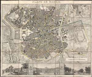
Plano de Madrid.
sold
- Digital Map Information
- Suitable for large format printing
- DPI: 600
- File Size: 44.25 MB
- File Type: ZIP / TIFF
- ICC color profile embedded
- Delivered instantly via download link
This is a beautiful 1846 Pedro Martín de López city map or plan of Madrid, Spain. The map depicts the city from the Manzanares River to Retiro Park (Parque del Buen Retiro) and from the Puerta de Bilbao to the Puerta de Toledo. Presented in exceptional detail and fine engraving, over 180 different locations are numerically identified numerically. Streets throughout the city are labeled, including the Calle Mayor. An inset of Madrid and its environs is situated in the upper right corner. Three views, illustrating the Fuente de la Cibeles, the Real Palacio, and the Puerta de San Vicente are included along the bottom border and separated by the Coat of Arms of Spain and Madrid. (more details)