
McGregor, Angus Harris (sold)

Angus Harris McGregor (January 16, 1901 - September 24, 1977) was an American engineer, cartographer, and inventor. Born in Melrose, Florida, McGregor lived his most of his adult life in Miami, Florida. He began issuing hurricane maps of the southeastern United States and the Caribbean in 1931 and issued new editions annually, using dashed and dotted lines to track the paths of the storms. He sold the maps to undertakers, insurance companies, roofing companies, and other related businesses for distribution. In 1939, after a New England hurricane, companies in New England requested copies of his map, and that year he expanded the map's coverage area to include from Canada to northern South America. McGregor also created the official Miami-Dade County precinct map published in 1934. McGregor published editions of his hurricane map through at least 1964. On October 28, 1940, McGregor was injured in a railroad accident when a switch engine struck his car at N.W. Seventh Avenue and 73rd Street in Miami. He suffered head, leg, chest, and internal injuries and sued the Florida East Coast Railway claiming permanent disability. A jury awarded him $22,500 in June 1942. On his World War II draft card, completed in February 1942, he included under 'obvious physical characteristics', 'left eye artificial, scar right forehead, right leg partially paralyzed'.
Tracing 20 years of Atlantic hurricanes.
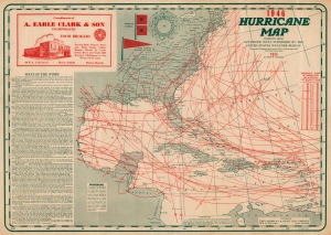
Hurricane Map 1946. Compiled from Authentic Data Furnished by the United States Weather Bureau Showing the Approximate Center Paths of Hurricanes and Near Hurricanes since 1924.
sold
- Digital Map Information
- Suitable for large format printing
- File Size: 48.65 MB
- File Type: ZIP / TIFF
- ICC color profile embedded
- Delivered instantly via download link
This is a 1946 Angus McGregor hurricane map of the Caribbean Sea, Gulf of Mexico, and the eastern United States. The map is a fascinating infographic achievement, tracking Atlantic hurricanes for over 20 years, from 1924 through 1945. Issued for commercial distribution and advertising, the map's also underscore a nation fascination with the powerful and destructive tropical storms. (more details)