
Merkus, Henricus (sold)

Henricus Merkus (1714 - 1774) was a Dutch publisher. Born in Nijmegen, Markus worked with his half-brother Johann Caspar Arkstée (c. 1700 - c. 1782) in the publishing firm Arkstée and Markus in Leipzig and Amsterdam.
State-of-the-art mapping of Lake Champlain at the outbreak of the French and Indian War.
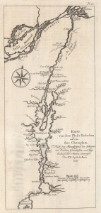
Karte von dem Fluße Richeliue und dem See Champlain Nach den Manuscripten des Schatzes von Karten Grüdrißen und Tagebüchern der Marine.
sold
- Digital Map Information
- Suitable for large format printing
- File Size: 3.14 MB
- File Type: ZIP / TIFF
- ICC color profile embedded
- Delivered instantly via download link
This is the 1756 German edition of the 1744 Bellin map of Lake Champlain and the St. Lawrence River. Bellin composed this map from French surveys conducted in the 1740s, making it one of the earliest accurate maps of Lake Champlain. This map was the state-of-the-art of Lake Champlain cartography and was the best available map of Lake Champlain at the outbreak of the French and Indian War (1754 - 1763) and the American Revolutionary War (1775 - 1783). Bellin's work was only supplanted when the British published Brassier's map in 1776. (more details)