
Monecke, C. (sold)

C. Monecke (fl. c. 1850 - 1860) was a German lithographer based in Berlin. Monecke, who published as 'Inst. von C. Monecke' is associated with several German cartographers of the mid-19th century, including Heinrich Kiepert and Richard Lepsius.
First German map of the state of California.
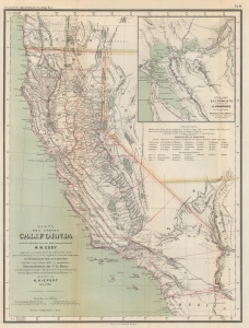
Karte des states California nach er officiellen Karte des State Surveyor General W. M. Eddy (approved and declared to be the official Map of the State of California by act of the Legislature, passed March 25th 1853) mit Berichtigung der Küste und einzelner Pässe nach den in den Jahren 1855-4 asusgeführten Künstenaufnahmen der V. St. Marine unde Recognoscirugen projectirter Eisenbahnlinien durch die Ingenieur Oficiere Gunnison, Beckwith, Williamson, u. a. gezeichnet von H. Kiepert Berlin 1856.
sold
- Digital Map Information
- Suitable for large format printing
- File Size: 10.6 MB
- File Type: ZIP / TIFF
- ICC color profile embedded
- Delivered instantly via download link
This is a rare 1856 H. Kiepert German edition of William M. Eddy's first official map of California. This is the first German-language map specifically of the state of California. (more details)