
Montross and Clarke Company (sold)

The Montross and Clarke Company (fl. c. 1907 - 1934) was a commercial stationary, printing, and blank book business. Incorporated by William F. Montross, James L. Clarke, and Russell R. Cornell in New York City, they took over the business of Montross, Clarke, and Emmons, manufacturing stationers.
Depicts the rail network of the Atchison, Topeka and Santa Fe railway - the second transcontinental rail route.
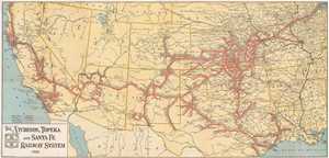
The Atchison, Topeka, and Santa Fe Railway System.
sold
- Digital Map Information
- Suitable for large format printing
- File Size: 14.94 MB
- File Type: ZIP / TIFF
- ICC color profile embedded
- Delivered instantly via download link
This is a 1926 Montross and Clarke map of the Atchison, Topeka and Santa Fe (ATSF) railway network in the Western United States. The map depicts the region from the Pacific Ocean to Chicago and from Oregon, Idaho, Wyoming, Nebraska, Iowa, and Illinois to Texas, ... (more details)