
Müller, Otto Martin (sold)

Otto Martin Müller (March 16, 1913 - November 30, 2002) was a Swiss artist and graphic designer. Müller was born and grew up in Zurich, Switzerland. He apprenticed as a lithographer from 1928 to 1929. Afterwards he matriculated at the Art Institut Orell Füssli where he was exposed to German Expressionism and the Bauhaus Dessau. Müller started working as a freelance graphic designer in Zurich in 1934, and in 1937 he received commissions from the Swiss Traffic Center. Among these works was a pictorial map of Switzerland, which was published in 1941. This map was his first major success. Afterwards, he designed several other pictorial maps of Zurich, Graubündchen, and Ticino. He also created title pages and illustrations for books. His most well-known piece is his 'Cheese Map of Switzerland' issued for the Schweizer Käseunion, published in various editions from 1967 to 1994. Müller died in Affoltern am Albis on November 30, 2002.
Zurich tourism.
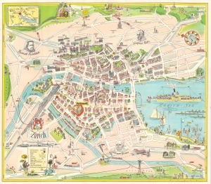
Zurich.
sold
- Digital Map Information
- Suitable for large format printing
- Full resolution TIFF file
- ICC color profile embedded
- Delivered instantly via download link
This is a c. 1950 Otto M. Müller pictorial map of Zurich, Switzerland, published by the department store Jelmoli. (more details)
Tutti siamo pellegrini, noi che cerchiamo Italia.
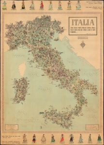
Italia salve, magna parens frugum, Saturnia tellus, magna virum: tibi res antiquae laudis et artis ingredior... / Carta Ideografica d'Italia. Ideographic Map of Italy. Carte Ideographique d'Italie. Ideographische Karte von Italien. Mapa Ideografico de Italia.
sold
An imposing pictorial map of Italy drawn by Otto M. Müller and E. V. Clementi, published in 1965 by the Istituto Cartografico Italiano. The map's colorful illustrations celebrate Italian culture from the Alps to Sicily. Aside from its clear celebration of Italy's diversity, the map also reflects collective relief after the tumultuous years of fascism and war. It might also represent a fear of cultural homogenization amid Italy's postwar economic miracle, as mass media, consumerism, and other forces of modernity began to erode the distinctiveness of the country's regions. (more details)