
National Survey Company (sold)

The National Survey Company (1912 - 2000) was a map publishing firm based in Chester, Vermont, founded by Lawton V. and Henry F. Crocker in 1912. The Crockers began their careers in the map trade as part-time summer traveling salesmen for The Bullard Company of Boston. However, their relationship with Bullard fell apart in 1912, which forced the brothers to found their own company. They created and published their own maps, with a series of detailed road maps leading to early success. They published maps in varying formats, from pocket maps to wall maps to road atlases. However, the free promotional oil company maps published in the 1920s by firms like Rand McNally almost forced National Survey out of the market. At this point they moved to Chester, Vermont, narrowly avoided bankruptcy, and refocused. They began creating their own promotional maps and travel publications, mainly for hotel and motel chains in New England. During World War II, they completely changed tactics again, and exclusively focused on war production. They published topographic maps for the Army Map Service and nautical charts for the Navy's Hydrographic Office. Work for the Army and Navy continued after the war, even with a renewed focus on tourist maps and guides. In 2000, National Survey was bought by Universal Map, who chose to continue operating out of Chester, Vermont.
'Rusticators' become 'Tourists'.
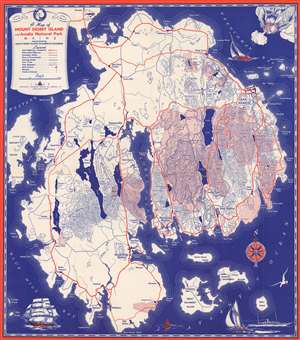
A Map of Mount Desert Island and Acadia National Park Maine.
sold
- Digital Map Information
- Suitable for large format printing
- Full resolution TIFF file
- ICC color profile embedded
- Delivered instantly via download link
This is a 1938 National Survey Company tourist map of Mount Desert Island, Maine, likely created 'rusticators' visiting Acadia National Park. Pink areas highlight the park's boundaries. Highways, secondary roads, and Mount Desert Island's celebrated carriage roads are illustrated. Charming pictorial elements occupy the three corners, including a personification of wind blowing a sailboat along the island's northern coast. (more details)
'Rusticators' become 'Tourists'.
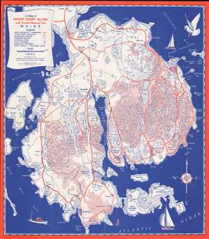
A Map of Mount Desert Island and Acadia National Park Maine.
sold
- Digital Map Information
- Suitable for large format printing
- File Size: 330 MB
- File Type: ZIP / TIFF
- ICC color profile embedded
- Delivered instantly via download link
This is a 1950 National Survey Company tourist map of Mount Desert Island, Maine, likely created 'rusticators' visiting Acadia National Park. Pink areas highlight the park's boundaries. Highways, secondary roads, and Mount Desert Island's celebrated carriage roads are illustrated. Charming pictorial elements occupy the three corners, including a personification of wind blowing a sailboat along the island's northern coast. (more details)
Maritime businesses along Florida's Atlantic and Gulf coasts.
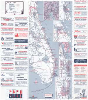
This is a 1978 National Survey map of Florida, created as an advertisement for Florida's marinas and other coastal 'facilities'. Eastern Florida appears on the recto and western Florida is printed on the verso. Advertisements promoting marinas, ship electronics sellers, a canvas shop, and a yacht builder, along with several other businesses, occupy approximately half the recto. Red dots bearing corresponding numbers mark businesses. Highways and interstates, along with the Florida Turnpike, are illustrated inland, while cities and towns are labeled throughout. Major cities and tourist destinations, such as Walt Disney World, are labeled in bold. Inset maps detailing Jacksonville, St. Augustine, Stuart, Titusville and the John F. Kennedy Space Center, West Palm Beach, and Fort Lauderdale are situated in the Atlantic to the right of Florida. (more details)