
Nishizawa Taro (sold)

Nishizawa Taro (fl. c. 1931 - 1940), or 西澤太郎 was a Japanese cartographer active during the Second Sino Japanese War. He may have been a military surveyor attached to the Central China Expeditionary Force under General Shunroku Hata.
Map of Hankou at the height of the Second Sino-Japanese War.
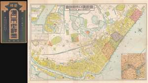
最新漢口市街詳圖 / New Detailed Street Map of Hankou. / 附武昌漢陽市街圖 / Annexed Street Map of Hangyang, Wuchang. / 漢口附近圖 / Map of Hankou's Surroundings.
sold
- Digital Map Information
- Suitable for large format printing
- File Size: 46.54 MB
- File Type: ZIP / TIFF
- ICC color profile embedded
- Delivered instantly via download link
This is a scarce 1939 or Showa 14 Taro Nishizawa (西澤, 太郎) city map or plan of Hankou (Wuhan), China issued during the Second Sino-Japanese War (1937 - 1945, 抗日战争) shortly following the fall of Wuhan and Hankou in 1938. In addition to this map's importance to the war, it is noteworthy that it represents Hankou emergence from roughly 15 years of urban redesign, renewal, and redevelopment as a 'garden city' under the progressive mayors Liu Wen-Tao (1929 - 1931) and Wu Kuo-Chen (1932 - 1936). (more details)