
Osaka Mainichi Shimbun (毎日新聞)

The Osaka Mainichi Shimbun (大阪毎日新聞; 1876 - 1942) was an Osaka based daily newspaper active in the late 19th and early 20th century. The Osaka Mainichi Shimbun (大阪毎日新聞, Osaka Daily News) was founded in 1876 as Osaka Nippo(大阪日報). In 1888 it was renamed Osaka Mainichi Shimbun. In 1911 it merged with the Tokyo Nichi Nichi Shimbun (東京日日新聞), but both companies continued to print their newspapers independently until 1943, they were consolidated under the Mainichi Shimbun (毎日新聞, Daily News) masthead. The Mainichi Shimbun is today one of Japans larges and longest lasting newspapers.
Osaka Mainichi Shimbun is also known as: 毎日新聞
How a wood and paper city burns.
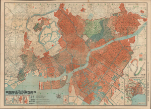
帝都大震火災系統地圖 / Map of the Fire of Tokyo.
$2,500.00
Acquire
- Digital Map Information
- Suitable for large format printing
- Full resolution TIFF file
- ICC color profile embedded
- Delivered instantly via download link
An exceptional example of an infographic masterpiece detailing the ignition and development of the Great Fire of Tokyo following the 1923 Great Kanto Earthquake. This partially bilingual 1923 map of the Great Tokyo Fire was issued by the Relief Information Bureau of Tokyo Imperial University just four months after the disaster. It focuses on ignition points and on the strong winds that coincided with the earthquake, which caused fire to spread rapidly and eventually burn down much of the dense wooden city. This example includes the original index, which we have never seen before, as well as its paper sleeve. (more details)
Charming pictorial map of the world, with illustrations of cannibalism.
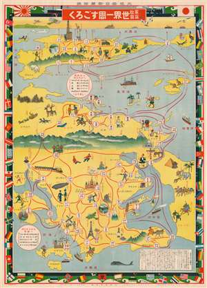
家庭教育世界一周すごろく / [Home Education Round-the-World Sugoroku].
$750.00
Acquire
- Digital Map Information
- Suitable for large format printing
- File Size: 90.21 MB
- File Type: ZIP / TIFF
- ICC color profile embedded
- Delivered instantly via download link
This is an exceptionally charming Taisho 15 or 1926 Japanese pictorial world map and round-the-world sugoroku game published as a supplement to the New Year's Edition of the Osaka Mainichi Shimbun (大阪毎日新聞). Aside from entertainment, the game was meant to inculcate geographic knowledge, especially of Europe and North America. (more details)
Guide to Japan's Historical Heartland.
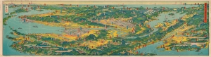
近畿を中心とせる名勝交通大鳥瞰圖 / [A Bird's-Eye View of Scenic Spots and Transportation Centered on the Kinki Region].
$500.00
Acquire
- Digital Map Information
- Suitable for large format printing
- Full resolution TIFF file
- ICC color profile embedded
- Delivered instantly via download link
A stunning 1926 bird's-eye view of the Kansai region of Japan drawn by Yoshida Hatsusaburō and published in Osaka Mainichi Shimbun. Both beautiful and functional, the view and its verso provide a comprehensive guide for tourists and travelers to the region. (more details)
Japan's Mountainous Southern Island.
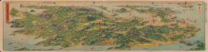
日本鳥瞰九州大圖繪 / [Bird's Eye View of Japan - Large Illustrated Map of Kyushu].
$500.00
Acquire
- Digital Map Information
- Suitable for large format printing
- Full resolution TIFF file
- ICC color profile embedded
- Delivered instantly via download link
A spectacular bird's-eye view of Kyushu, the southernmost of Japan's home islands, drawn by Yoshida Hatsusaburō and published in the Osaka Mainichi Shimbun in 1927. It thoroughly overviews the mountainous island, its transportation network, many culturally significant sites, and leisure destinations. (more details)
Graphically wonderful Japanese world aviation board game.
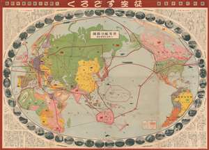
世界航空路圖 / Sekai kōkūrozu. / World Aviation Route Map. / 征空すごろく/ Seikū su-goro ku.
$700.00
Acquire
- Digital Map Information
- Suitable for large format printing
- File Size: 212.57 MB
- File Type: ZIP / TIFF
- ICC color profile embedded
- Delivered instantly via download link
A rare 1930 or Showa 5 Japanese pictorial map of the world and sugoroku game. Presented on a Mollweide projection and centered on Japan, this map illustrates the entire world and historic flights paths are highlighted in red. The historic flights noted include the Circumnavigation of World by the United States Army Air Corps (USAAC) in 1924, Charles Lindbergh’s Solo Transatlantic Flight (May 20-21, 1927), the Airship Italia’s route to the North Pole (1928), and the Circumnavigation by the Graf Zeppelin airship in 1929. The map proper is surrounded by 52 vignette images illustrating global capitals, countryside, flora, fauna, and culture. (more details)
One of the most consequential battles of the Second Sino-Japanese War.
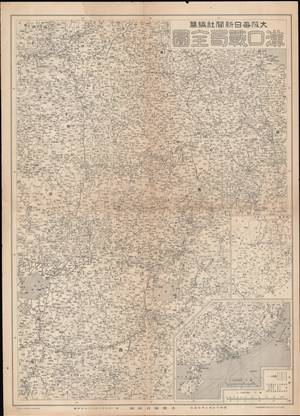
漢口戰局全圖 / [Complete Map of the Hankou War Situation].
$350.00
Acquire
- Digital Map Information
- Suitable for large format printing
- File Size: 22.24 MB
- File Type: ZIP / TIFF
- ICC color profile embedded
- Delivered instantly via download link
This is a 1938 map of the Battle of Wuhan in the Second Sino-Japanese War (1937 - 1945) theater of World War II (1939 - 1945). It was published for the Japanese news daily, the Osaka Mainichi Shimbun. It covers much of central and southern China, particularly near the Yangtze River, in great detail; the battle raged over this area for much of the summer and autumn of 1938, resulting in a pyrrhic Japanese victory. (more details)