
Platen, Charles G. (sold)

Charles G. Platen (1818 - 1884) was a German-born Savannah Georgia based architect, lawyer, 'daguerrian artist,' possibly a hatmaker, and map publisher active in the second half of the 19th century. Platen was born in Brunswick, Germany. Evidence suggest his birth name was Moritz Karl Gottfried Von Platen. He may have shortened it to Charles when he emigrated to the United States in 1848, Forty-Eighter fleeing the Revolutions of 1848. He landed in New Orleans in November of that year. Between his arrival and September of 1859, when he settled in Savannah, Georgia, Platen appears to have moved around a bit, settling briefly in Buffalo, New York and later in Charleston, South Carolina, where he worked as a daguerreotype artist. During the American Civil War (1861 - 1865), where he served in the Olmstead's 1st Regiment, Georgia Infantry, and was posted on Sullivan's Island, South Carolina. He declared his intent to become naturalized U.S. Citizen on December 18, 1871. He appears in Savannah directories, where he is listed as an 'architect and lawyer' until 1884. He had at least one child, Hugo Platen (1859 - 1925), who was born in Charleston, in 1859. The 1860 census also records a Pauline Platen (1838 - 18??), born in Hamburg. If our association of Charles G. Platen with Moritz Karl Gottfried Von Platen is correct, this is his much younger wife Pauline Ernestine Friederike Von Platen. In March of 1884, Platen received his naturalization papers. His signature on these documents represent an extremely weak and shaky hand, suggesting infirmity. There is no evidence of Platen after 1884, but there is some suggestion that he may have returned to Germany to visit or live in that year, and may have died there.
The First Large Format Map of Chatham County, Georgia.
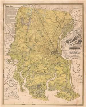
Chatham County State of Georgia Compiled Exclusively from certified plats and maps of the most eminent local surveyors by Charles G. Platon.
sold
- Digital Map Information
- Suitable for large format printing
- File Size: 98.41 MB
- File Type: ZIP / TIFF
- ICC color profile embedded
- Delivered instantly via download link
A rare and extraordinary 1875 Reconstruction Era map of Chatham County, Georgia, illustrating in large the vicinity of Savannah. This map was published by Charles G. Platen, who incorporated local survey work, the 1818 John McKinnon map, and the meticulous work of the U.S. Coast survey to compile this, the largest and most detailed map of the Savannah area ever issued. The intent behind the map, to develop agricultural lands, is evident in the color coding, with green referencing lowlands, swamps, and other wetlands, blue representing water, and yellow arable land. Platen advances the map considerably by drawing on the work of 36 local surveyors, all of which are named, to add property lots and owners throughout. (more details)