
Prather, Ralph Carlyle (sold)

Ralph Carlyle Prather (November 4, 1889 - April 7, 1953) was an illustrator, draftsman, and printer active in St. Petersburg, Florida, and Denver, Colorado, in the early 20th century. Prather was born in Franklin, Pennsylvania, but grew up in St. Petersburg, Florida, graduating from St. Petersburg High School in 1909. His father, George C. Prather, worked in the Travel industry. Ralph began working as a commercial draftsman around 1912. He appears to have been something of a 'man about town' in St. Petersburg, where he is described by the Tampa Bay Times as 'one of the most popular young men in the city, belonging to the best clubs in St. Petersburg.' Prather ran the 'Prather Studio', which specialized in blueprints for local surveyors - a service he promoted as the 'Electric Blue Printing Dept. of the Prather Studio'. He married Claire McCullough, of Ohio, in 1915, immediately after which he moved to Denver, Colorado, where he took work as a draftsman for the Midwest Refining Company. During this period, he also issued several spectacular aerial views of Colorado Mountains as well as, in 1918, Prather’s Aeroplane Map of the World’s Battle Field, of which there are no known surviving examples. He remained with Midwest Refining until 1922. Afterwards he studied illustration under Charles Livingston Bull (1874 - 1932). By 1924, he established himself as a nature illustrator, specializing in drawing animals. He was living in Pennsylvania for a time after 1925, but ultimately returned to St. Petersburg, Florida. He was also an accomplished writer, publishing numerous magazine articles and short stories co-authored with his wife, Claire. Prather died in St. Petersburg in 1953.
Early urbanization of Pinellas County.
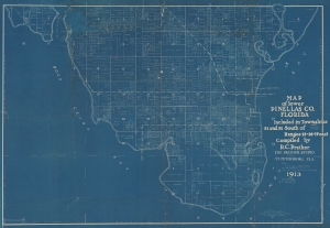
Map of Lower Pinellas Co. Florida Included in Townships 31 and 32 South of Ranges 15-16-17 east Compiled by R. C. Prather.
sold
- Digital Map Information
- Suitable for large format printing
- File Size: 234.12 MB
- File Type: ZIP / TIFF
- ICC color profile embedded
- Delivered instantly via download link
An extraordinary 1913 Ralph Carlyle Prather cyanotype map of the southern part of the Pinellas County Peninsula, near Tampa, Florida. It illustrates the early urbanization not only of Tampa Bay and Pinellas County, but also of the wider Florida Land Boom that would reach its peak 8 year later. (more details)