
Rock, Miles (sold)

Miles Rock (1840 - 1901) was an English-American astronomer, surveyor, and engineer. After emigrating to the United States and volunteering to fight in the U.S. Civil War, Rock studied engineering at Lehigh University and then worked as an astronomer for the U.S. government. In 1883, he began working for the government of Guatemala, eventually rising to Chief of the Guatemala Boundary Commission, which helped to fix the country's border with Mexico.
The difficulties of demarcation.
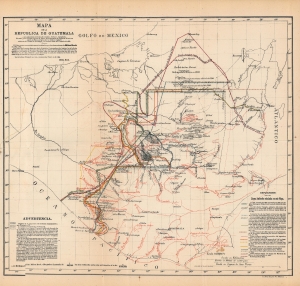
Mapa de la República de Guatemala, los adyacentes estados Mexicanos de Chiapas, Tabasco, Campéche y Yucatan, y la colonia inglesa de Belice...
sold
- Digital Map Information
- Suitable for large format printing
- File Size: 7.94 MB
- File Type: ZIP / TIFF
- ICC color profile embedded
- Delivered instantly via download link
A rich 1895 Spanish-language map of Guatemala produced by American surveyor Miles Rock. Rock was employed by the Guatemalan government to demarcate the border, which had been disputed with Mexico in the preceding decades, causing a diplomatic crisis that became a model study in international law. (more details)