
Russian Military Topographic Depot (sold) (Военно-топографическое депо)

Russian Military Topographic Depot (Военно-топографическом депо; January 27, 1812 - October 16, 1863) was a Russian Imperial Army surveying, mapmaking, publishing, and archival institution based in St. Petersburg during the 19th century. Its predecessor, the Map Depot (Депо карт), was established in 1797 after the creation of an imperial drafting office in 1796 and centralized the collection, compilation, and publication of maps for military and government use. Reorganized in 1812 as the Military Topographic Depot under the war minister, the institution coordinated astronomical observations, geodetic measurements, topographic surveys, map compilation, engraving, and printing, while preserving maps, plans, statistical descriptions, and records of military operations. Its original organization comprised six branches responsible for special assignments, astronomical and trigonometric work, map compilation and drawing, archives, engraving and printing, and administration. During Napoleon’s invasion of Russia in 1812, it reissued existing maps for military use; after the conflict, systematic surveying expanded, particularly in the empire's western provinces and frontier territories. The Corps of Topographers, established in 1822, strengthened the personnel and technical training available for these operations. Fyodor Fyodorovich Schubert (1789 - 1865), a leading administrator of the corps and the depot's surveying work, promoted instruction in mathematics, geodesy, drawing, and topographic description. The depot thus connected field observations with centralized cartographic production and the preservation of military geographical information. Its responsibilities were not uniform across the empire: from 1854, the Military Topographic Department of the Separate Caucasian Corps headquarters concentrated military surveying and mapping in the Caucasus. On October 16, 1863, the depot was abolished and its functions transferred to the Military Topographic Section of the Directorate of the General Staff (управления Генерального штаба). In 1866, the former Corps provided the technical and personnel basis for the Corps of Military Topographers (Корпус военных топографов), which underwent several reorganizations and name changes throughout the 20th century. During the Cold War, it was known as the Military Topographic Directorate of the General Staff (Военно-топографическое управление Генерального штаба, often abbreviated as VTU). Even today, as part of the armed forces of the Russian Federation, it retains a similar name and function as in imperial times.
AKA: Военно-топографическое депо
One of the most important maps of Siberia made in Tsarist times.
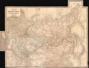
Карта Азіятской Россіи с прилегающими к ней владѣниями / [Map of Asian Russia, with Adjacent Possessions].
sold
- Digital Map Information
- Suitable for large format printing
- Full resolution TIFF file
- ICC color profile embedded
- Delivered instantly via download link
This is an rare and important 1884 Russian-language map of the Russian Empire, focusing on Siberia and the Russian Far East, produced by the Military Topographic Department of the Imperial Army's General Staff. It represents a major advance in detailed geographical and cartographic knowledge of Siberia at a time, when the Tsarist government was increasingly interested in settling colonists and exploiting the resources of the vast region. (more details)
Railways, Settlers, and Resenments in Russian Central Asia.
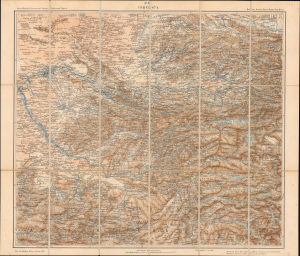
Карта южной пограничной полосы азиатской россіи XIX. Ташкентъ / [Map of the Southern Border Zone of Asiatic Russia XIX. Tashkent].
sold
- Digital Map Information
- Suitable for large format printing
- Full resolution TIFF file
- ICC color profile embedded
- Delivered instantly via download link
This is an 1892, updated to 1910, Russian-language map of Central Asia, prepared by the Military Topographic Department of the Main Staff of the Imperial Russian Army. Focusing on the area between Bukhara and the Ferghana Valley, it provides exceptional topographic detail of the region, which had only come under Russian rule in the preceding decades. In the wake of Russian conquest came railways, settlers, and increased ethnic tensions, which would cause the region to explode as Russia's empire collapsed during the First World War. (more details)