
Smeltzer, Sterling Brookbank (sold)

Sterling Brookbank Smeltzer (November 5, 1908 - January 26, 1982) was an American artist. Born in Williamsburg, Pennsylvania, Smeltzer graduated from Altoona High School in 1927. He then attended Carnegie-Tech (the forerunner of Carnegie-Mellon University), majored in Engineering and Structural Design and Art, and graduated in 1931. Later, he attended the University of California-Los Angeles and the Ohio State University. He painted murals in post offices for the Works Progress Administration during the Depression. Then, he worked for the Curtiss-Wright Airplane Company from 1942 - 1951, where he worked on handbooks and manuals in the Service Engineering Department in the Technical Publications Group. He was then promoted to Section Head, and finally to Service Engineer, where he supervised the Handbooks and Bulletin Groups and the Industrial Art Section. Before he left Curtiss-Wright, Smeltzer became the Chief of Field Services for all Curtiss-Wright Airplane Division Products. Smeltzer left Curtiss-Wright in 1952 to become the General Superintendent of Field Service at North American Aviation, Inc. Smeltzer married his wife Evelyn Byrd on October 12, 1951.
'Almost heaven! West Virginia.' - John Denver
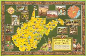
Recreational Map of West Virginia.
sold
- Digital Map Information
- Suitable for large format printing
- File Size: 57.48 MB
- File Type: ZIP / TIFF
- ICC color profile embedded
- Delivered instantly via download link
This is a 1941 Sterling B. Smeltzer pictorial map of West Virginia. Pictorial vignettes highlight West Virginia's many state parks, state forests, game refuges, and historical sites in the hopes of enticing tourists to visit. Pictorial icons also illustrate the state's natural resources, which include coal, natural gas, and oil, along with livestock. Idyllic views surround the central map and depict people fishing, playing tennis, practicing archery, horseback riding, and West Virginia's picturesque landscapes. A round inset in the upper right quadrant provides distances between West Virginia and many surrounding cities, including New York City, Washington D.C., Chicago, Columbia, and Nashville. A pictorial border, drawn and colored to resemble a carved wooden frame, encircles the map and consists of illustrations of West Virginia's wildlife alongside its countryside, scenes of outdoor activities, and references to historic events. (more details)