
Strubicz, Maciej (sold)

Maciej Strubicz (1530-1604) was a Polish nobleman, cartographer and geographer. While nothing is known of his education, by the late 16h century he had become the principal geographer to the Polish king (and map aficionado) Stefan Batory. Strubicz is known to have produced maps of Livonia and Poland, but the only one that has survived is his 1589 Magni Ducatus Lithuaniae, Livoniae et Moscoviae Descriptio. He is known to have been commissioned with a further, more detailed map of Lithuania and Poland by Prince Michael Radziwill; this map, engraved by Hessel Gerritz for Blaeu in 1613, provided the basis for the mapping of north-eastern Europe for most of the 17th century.
A Richly Detailed Map of the Grand Duchy of Lithuania
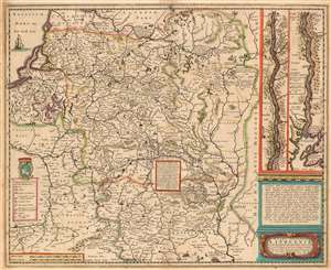
Magni Dvcatvs Lithvaniae caeterarumq ; regionum illi adjacentium exacta descrip./ Illss.mi ac Excell.mi Principis ac Dñi D. Nicolai Christophori Radziwil D.G. Olycae ac in Nieswies Ducis, S. Rom. Imp. Principis in Szylowiec ac Mir comitis, et S. Sepulchri Hirosolimitani Militis etc. opera et cura in lucem edita
sold
- Digital Map Information
- Suitable for large format printing
- DPI: 600
- File Size: 24.13 MB
- File Type: ZIP / TIFF
- ICC color profile embedded
- Delivered instantly via download link
This is Henry Hondius' 1636 map of the Grand Duchy of Lithuania, with inset maps of the course of the Dniepr River. The map encompasses Riga and Smolensk to the north, and Krakow to Kiev in the south. As such it includes parts of modern day Latvia, Lithuania, Poland, Belarus, Ukraine and Russia. The Dniepr insets continue mapping the river from Cherkasy to the river's opening in the Black Sea. The map is based on Willem Blaeu's 1613 wall map of the same title, derived from the 'Radvilas' map of the Grand Duchy of Lithuania. In 1586, the Lithuanian Prince Michael Radziwill commissioned the Polish royal cartographer Maciej Strubicz to produce a map which improved on his earlier map of Poland, Lithuania and Livonia; the resulting map would form the basis of most seventeenth century mapping of this part of the world. Using keys both in the main map and the insets, the cities are marked to indicate their religious (and hence their political) affiliations. The Dniepr maps indicate those forts and cities held by Christians and those held by Muslim 'Tatars;' the main map differentiates between cities of the Palatinates, Catholic bishoprics and Greek Orthodox bishoprics. The map reveals its 16th century naissance in its copious historical notes (with accompanying pictorial battle scenes) of important engagements, alliances and victories in the Polish-Lithuanian Commonwealth's 1579-1581 war with Muscovy. (more details)