
Stuart, Oliver J. (sold)

Oliver J. Stuart (1826 - c. 1890) was an American engraver based in New York and Brooklyn in the middle part of the 19th century. He registered for the draft in New York in 1863, at the time 39 years old. He has a moderate corpus of work, but little is known of his life. Stuart remained active until the 1880s.
One of the largest obtainable maps of the Confederacy.
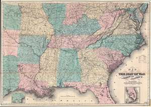
Map of the Seat of War to Accompany the American Conflict.
sold
- Digital Map Information
- Suitable for large format printing
- File Size: 63.95 MB
- File Type: ZIP / TIFF
- ICC color profile embedded
- Delivered instantly via download link
This is an 1866 Orlando D. Case and Company map of the southeastern United States. The map depicts the southern United States from the Mason-Dixon Line south to the Gulf of Mexico and from Kansas, Oklahoma (Indian Territory), and Texas to the Atlantic Ocean. This important map was published one year after the end of the Civil War in Horace Greeley's book The American Conflict. An important work about the war from the Unionist perspective, this map visualizes the information it provides. Highly detailed, state capitals, large cities, and towns are labeled throughout, from Ohio to Florida, with Washington, D.C. shaded in red. Civil War battle sites are labeled, along with railroads and rivers, key components to the war for both the Union and the Confederacy. The topography along the coast from South Carolina to Virginia, which played an important role in the war, is illustrated. Two inset maps are present: one, in the lower right, illustrates the lower portion of Florida, the other, in the lower left, depicts the lower portion of Texas. (more details)