
Sudo Katsuzō (sold)

Sudo Katsuzō (湏藤 / 湏藤勝三; c. 1848 - c. 1874) was a Japanese cartographer of Tochigi Prefecture (栃木県 / Tochigi-ken), Japan. Sudo was part of an 1874 mission to Taiwan and subsequently to the mainland of China. As part of this expedition, he produced a series of maps detailing Taiwan and some major cities in Fujian, including Fuzhou and Xiamen. The quality and execution of the maps suggest that he was experienced in both western and Japanese cartographic styles, indicating that he may have had training as a military engineer. Sudo apparently died of an unknown illness shortly after the maps were made, at just 26, so it is not surprising that little is recorded regarding his history. His maps were subsequently collected by his brother and remained in the family until recently.
Japanese mansucript version of the 19th century Admiraltly chart of Taiwan. Part of a set.
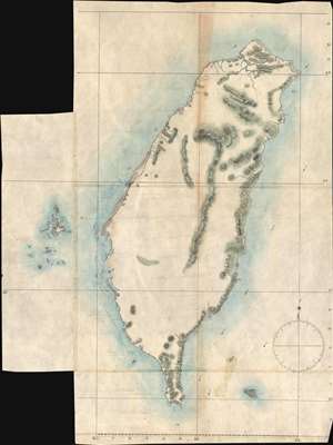
[Formosa]
sold
- Digital Map Information
- Suitable for large format printing
- Full resolution TIFF file
- ICC color profile embedded
- Delivered instantly via download link
Part of Sudo Collection. Not sold Separately: Click here for full collection. The third and smallest of the general maps of Taiwan in the Sudo collection. This map is based upon British Admiralty chartings of the island combined with the 1861 - 1864 work of ... (more details)
Sudo manuscript map of south Formosa based upon Legendre. Part of a set.
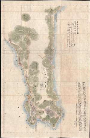
台灣南部之圖 / Map of the Southern Part of Taiwan.
sold
- Digital Map Information
- Suitable for large format printing
- File Size: 16.98 MB
- File Type: ZIP / TIFF
- ICC color profile embedded
- Delivered instantly via download link
Part of Sudo Collection. Not sold Separately: Click here for full collection. The largest of the two south Taiwan detail manuscript maps from the 1874 Sudo series. Like Sudo's large map of Formosa, the present example is derived from the work of the American ... (more details)
Japanese mansucript version of the 1870 Le Gendre map of Taiwan. Part of a set.
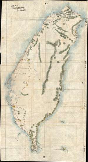
[Formosa]
sold
- Digital Map Information
- Suitable for large format printing
- File Size: 171.72 MB
- File Type: ZIP / TIFF
- ICC color profile embedded
- Delivered instantly via download link
Part of Sudo Collection. Not sold Separately: Click here for full collection. By far the largest map in the Sudo collection. It is based almost entirely on the American Consul to Qing Taiwan Charles William (Guillaum) Joseph Émile Le Gendre's (August 26, ... (more details)
Detailed Map of Tamsui Harbor and River Entrance, Taiwan.
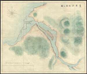
台湾淡水港之图 / Map of Tamusi Harbor.
sold
- Digital Map Information
- Suitable for large format printing
- Full resolution TIFF file
- ICC color profile embedded
- Delivered instantly via download link
Part of Sudo Collection. Not sold Separately: Click here for full collection. An interesting map detailing the entrance to the Tamsui River and Tamsui Harbor, near modern day Taipei, Northern Taiwan. Tamsui has a long history of association with foreign ... (more details)
General Map of Tamsui River Entrance, Taiwan.
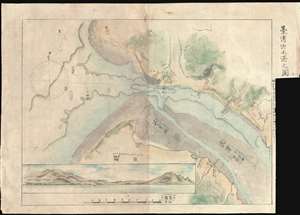
台湾淡水港之图 / Map of Tamusi Harbor.
sold
- Digital Map Information
- Suitable for large format printing
- Full resolution TIFF file
- ICC color profile embedded
- Delivered instantly via download link
Part of Sudo Collection. Not sold Separately: Click here for full collection. A striking general map detailing the entrance to the Tamsui River and Tamsui Harbor, near modern day Taipei, Northern Taiwan. The map includes a large profile view ... (more details)
Sudo manuscript map based upon Legendre. Part of a set.
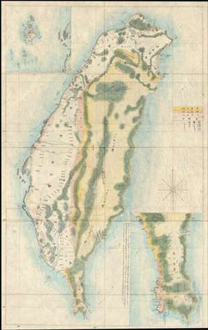
[Formosa]
sold
- Digital Map Information
- Suitable for large format printing
- File Size: 28.47 MB
- File Type: ZIP / TIFF
- ICC color profile embedded
- Delivered instantly via download link
Part of Sudo Collection. Not sold Separately: Click here for full collection. One of the two largest maps in the collection, this finely executed manuscript map of Taiwan covers the entire island with insets of the Pescadore or Penghu Islands ... (more details)
Manuscript map of Fuzhou, Fujian, China
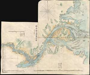
福刕港口南台廹圖 / Fuzhou Port South Station.
sold
- Digital Map Information
- Suitable for large format printing
- Full resolution TIFF file
- ICC color profile embedded
- Delivered instantly via download link
Part of Sudo Collection. Not sold Separately: Click here for full collection. A striking 1874 manuscript map of Fuzhou harbor (福州市), China. The map focuses on the entrance to the Minjiang River, with Langquidao Island featured ... (more details)
The most enigmatic map of the Sudo series illustrating the aboriginal tribes of Southern Taiwan.
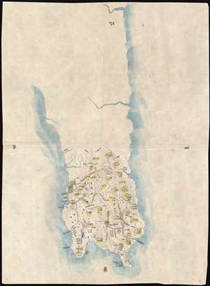
[Map of the Southern Part of Taiwan]
sold
- Digital Map Information
- Suitable for large format printing
- File Size: 18.35 MB
- File Type: ZIP / TIFF
- ICC color profile embedded
- Delivered instantly via download link
Part of Sudo Collection. Not sold Separately: Click here for full collection. This is by far the most enigmatic and elusive of the Sudo 1874 series. The map is laid down on the framework established by the previous map, which is ... (more details)
Manuscrip map of Xiamen based on Admiralty surveys.
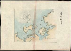
厦門港之圖 / Map of Xiamen Port.
sold
- Digital Map Information
- Suitable for large format printing
- File Size: 12.41 MB
- File Type: ZIP / TIFF
- ICC color profile embedded
- Delivered instantly via download link
Part of Sudo Collection. Not sold Separately: Click here for full collection. A striking 1874 manuscript map of Amoy or Xiamen harbor (厦门市), Fujian, China. The map is oriented to the South, but covers Xiamen Island and ... (more details)
Extraordinary manuscript map collection of Taiwan and Fujian relating to the 1874 Punitive Expedition and the cartography of Le Gendre.
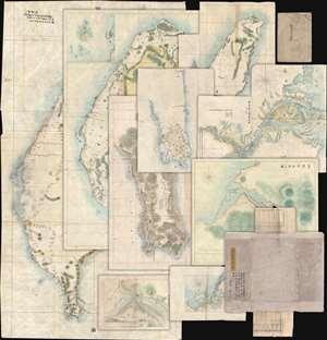
[Taiwan Manuscript Map Collection relating to 1874 Taiwan Punitive Expedition.]
sold
- Digital Map Information
- Suitable for large format printing
- Full resolution TIFF file
- ICC color profile embedded
- Delivered instantly via download link
An extraordinary collection of nine 1874 manuscript maps detailing Taiwan and part of Fujian province, China. The maps were compiled and drafted by one, Sudo Katsuzō (湏藤 or 湏藤勝三) of Tochigi Prefecture, Japan, on an official or semi-official 1874 mission to Taiwan and thence to mainland China. Most of the maps in this set were compiled between March of and June of 1874 and are related to the 1871 Mundan Incident and the subsequent 1874 Taiwan Punitive Expedition. The Taiwan maps are primarily derived from maps drawn by the American Consul to Qing Taiwan Charles William (Guillaum) Joseph Émile Le Gendre's (August 26, 1830 - September 1, 1899) between 1867 and 1873. Others, particularly those of mainland china and Tamsui, are derived from British Admiralty Hydrographic Charts. In addition to the manuscript maps, the collection also contains its original binder and Sudo's application booklet requesting permission to travel from Taiwan to Fujian and Shanghai. (more details)
Covers to the Sudo Taiwan collection.
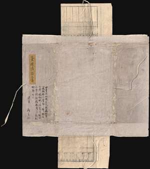
[Sudo Collection Covers]
sold
- Digital Map Information
- Suitable for large format printing
- File Size: 36.06 MB
- File Type: ZIP / TIFF
- ICC color profile embedded
- Delivered instantly via download link
Part of Sudo Collection. Not sold Separately: Click here for full collection. Original Covers of the Collection with text by Sudo's brother, describing Sudo's compilation of the maps and his death due to ... (more details)
Sudo's application for permission to travel to China.
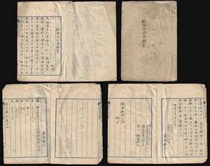
[Sudo Collection Passport]
sold
- Digital Map Information
- Suitable for large format printing
- File Size: 34.97 MB
- File Type: ZIP / TIFF
- ICC color profile embedded
- Delivered instantly via download link
Part of Sudo Collection. Not sold Separately: Click here for full collection. Manuscript Booklet: Overseas Navigation Permit Application for travel to Shanghai for one, Sudo, Tochigi Prefecture, ... (more details)