
Survey of Kenya (sold)

Survey of Kenya (1903 - present) is the official government body in charge of mapping and land surveying in Kenya. Established in the British colonial period, the body continued to function as before with the same name after Kenyan independence in 1963. In the years just before independence, the body produced the impressive Atlas of Kenya (editions in 1959 and 1962, both offered by us), which after independence was updated and expanded as the National Atlas of Kenya (1970). In the following decades, much of the Survey's work entailed creating land registries for the newly-independent country. Along with bureaucratic reorganization, the Survey's name was changed to the Ministry of Lands, and then the State Department for Lands and Physical Planning, housed within the Ministry of Lands, Public Works, Housing, and Urban Development.
Independence and Unity in Kenya
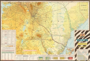
This impressive, large-format 1972 folding map of Kenya, northern Tanzania, and environs was produced by the Survey of Kenya. Loaded with information, including charts and tables in three languages, it provides a great deal of information on the region's ecology, terrain, and infrastructure. (more details)