
Therbu, Laurids de (sold)

Laurids de Therbu (17?? - ????) was a German cartographer, draftsman, publisher, and military engineer. Therbu is remembered for creating a series of 74 plans of battles during the Seven Years' War, 43 of which were published in Les Plan de la Guerre de Sept ans… in Mainz.
A French victory during the French and Indian War.
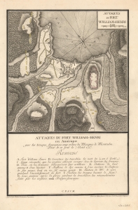
Attaques du Fort William-Henri.
sold
- Digital Map Information
- Suitable for large format printing
- File Size: 9.12 MB
- File Type: ZIP / TIFF
- ICC color profile embedded
- Delivered instantly via download link
This is a 1792 Laurids de Therbu map of the 1757 siege of Fort William Henry during the French and Indian War (1754 - 1763). It was built by the British in September 1755 on the southern shore of Lake George as a launching point for attacks against Fort St. Frédéric, a French fort. Both forts were part of a line of strongpoints along the strategic inland waterway from Montreal to New York City. (more details)