
Visconti, Sigismond (sold)

Sigismond Visconti (November 13, 1785 - 18??) was an Italian-French writer and scholar active in Paris during the early 19th century. Visconti was born in Rome. He is best known for his 1815 publication of a series of astronomical engravings illustrating the solar system as it was understood in the early 19th century.
Summation of 19th century astronomical knowledge.
Précis du Système Planétaire.
sold
- Digital Map Information
- Suitable for large format printing
- DPI: 600
- File Size: 359.94 MB
- File Type: ZIP / TIFF
- ICC color profile embedded
- Delivered instantly via download link
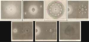
A stunning 1839 - 1859 set of 7 Sigismond Visconti astronomical charts issued by Auguste-Henri Dufour and Charles Simonneau. The charts represent the summation of astronomical knowledge regarding the Solar System and the orbits of the earth and moon, as understood in the early 19th century. The set consist of seven plates, which are as follows:
- The Solar System - Centered on the sun, displays the entire solar system as far as Neptune. Includes the asteroid belt objects Vesta, Junon, Ceres and Pallas. Identifies moos surrounding Earth, Jupiter, Saturn, Uranus, and Neptune. A comet, possibly Halley's, is also identified. Dated 1859. Revised by Dufour to reflect the 1846 discovery of Neptune.
- Orbit of the Earth - Details the orbit of the Earth around the sun, showing the axis of the Earth and the solar effects on the seasons. Equinox and solstice points are noted.
- Planisphere - Added to the Visconti set by Dufour in 1830. Illustrates the position of the Earth relative to the Sun in each month of the year. Four seasons are futher identified in each corner. So too are the signs of the zodiac. Dated 1839.
- Phases of the Moon - This chart illustrates the phases of the moon relative to the Earth and Sun. Dated 1839.
- Flux and Reflux - Attempts to illustrate the effect of the Sun and moon on the Tides relative to the rotation of the Earth and Moon. Dated 1839.
- Eclipses of the Sun and Moon - Illustrates the positions of the Sun and moon during full and partial solar and lunar eclipses. Dated 1839.
- Cross-section of the Earth - Illustrates the earth and its atmosphere as a cross-section. Radiating bands of shading illustrate the layers of the Earth. The volcanoes Pichincha in Columbia and Mount Ophir in Sumatra are noted. Also noted are the Galapagos Islands, South America, Africa, San Tome, the Maluku Islands, and the Isle of Dundas (British Columbia).