
York, Alice (sold)

Alice York (fl. c. 1926 - 1930) was an American educator and map publisher active in the first half of the 20th century. York published two educational pictorial maps. One, Child's Map of the Ancient World, in 1926 in partnership Ilonka Karasz (1896 - 1981), and a second, A Medieval Map of East and West in 1930 in partnership with Eduourd Léon Edy-Legrand. Little is known of her life, but she may have lived and worked in Los Angeles.
Rare pictorial map by famous French illustrator!
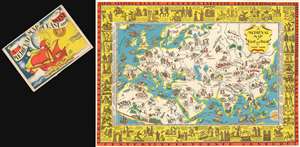
A Medieval Map of East and West by Alice York.
sold
- Digital Map Information
- Suitable for large format printing
- File Size: 61.04 MB
- File Type: ZIP / TIFF
- ICC color profile embedded
- Delivered instantly via download link
A rare 1930 pictorial map of Europe, Asia, and North Africa in the Middle Ages by Alice York and Eduourd Léon Edy-Legrand, accompanied by its original envelope. Although romanticizing a difficult historical period, the map is quite beautiful and inclusive in its scope, addressing not just European, but also Chinese, Japanese, Indian, Persian, and Arabian history. On the verso of the map's original envelope, there is a description of the map that exceeds anything we could write,
Here is a new map by Alice York - a delightful presentation of that colorful and romantic pageant of the Medieval World, characterizing civilization in Europe, Africa and Asia from the 5th to the 15th Century.The map is the 2nd of two maps issued by Alice York, both intended for educational work. (more details)
A glance at Spain shows us the Famous Alhambra and the Tower of Seville; in France we find Joan of Arc riding bravely to her fate; two Minnesingers wander about Germany while a member of the House of Hapsburg sits stoically upon his stronghold; a horde of Mongols is invading Russia and still further East Tamerlane the Great goes about his business of conquest. The Crusaders, too, are graphically pictured on their valorous arch to Jerusalem. And sea commerce, with all the hazards and adventures of the day, discovers new trade routes for the precious oriental cargoes which must be brought thousands of miles to enrich the centers of Europe.
Around the map is a border portraying, in chronological fashion, the more important figures and single outstanding events of the medieval centuries. We learn, for instance, that games of polo and chess were played in 531; that the Koran was introduced by Mohammed in 622; that Marco Polo described the wonders of China in 1275; that Robert Bruce won independence for Scotland in 1314 and that Chaucer wrote his famous Canterbury Tales in 1380.
There is rich historical treasure in this pictorial drama of Conquests and Discovers, Crusaders and Troubadours, beginning with the Fall of the Roman Empire in the West in the 5th Century and ending in the new Age of Discovery with the voyage of Columbus in the 15th Century. The map is stimulating, and provokes a desire to know more of this fascinating period. It is also, by virtue of its interesting cartography, especially adapted for use as a decoration, either in the home or in the school.