
A highly desirable state of Johnson's popular southwest map.

Johnson's California, with Utah, Nevada, Colorado, New Mexico and Arizona.
sold
- Digital Map Information
- Suitable for large format printing
- File Size: 15.78 MB
- File Type: ZIP / TIFF
- ICC color profile embedded
- Delivered instantly via download link
This is Johnson and Ward's desirable 1866 map of the American south-west. Depicts the state of California and the territories of Nevada, Utah, Colorado, Arizona and New Mexico. Offers superb detail throughout noting mining districts, emigrant trails, the Santa Fe ... (more details)

Johnson's New Map of the State of Texas.
sold
- Digital Map Information
- Suitable for large format printing
- File Size: 15.38 MB
- File Type: ZIP / TIFF
- ICC color profile embedded
- Delivered instantly via download link
An exceptional example of A. J. Johnson's highly desirable map of Texas. Created shortly after the American Civil War, this extraordinary folio map details the state of Texas in full. Identifies the Elevated Table Lands, the El Llando Estadado (the Staked Plain), ... (more details)

Boston Harbor.
sold
- Digital Map Information
- Suitable for large format printing
- File Size: 10.71 MB
- File Type: ZIP / TIFF
- ICC color profile embedded
- Delivered instantly via download link
This is an attractive two color lithograph 1897 view of Boston Harbor by George H. Walker & Co. Covers Boston harbor in full with its many islands, light houses, forts, and communities. The map part of the map covers Boston, South Boston and East Boston, naming ... (more details)
A fundamental rethinking of Colton's New York City plan.
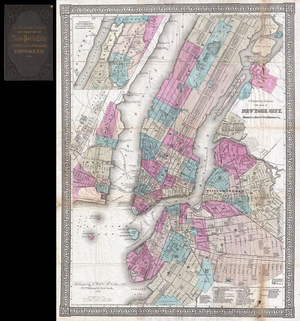
G. Woolworth Colton's New Map of New York City, Brooklyn, Jersey City, Hoboken, Etc.
sold
- Digital Map Information
- Suitable for large format printing
- File Size: 19.41 MB
- File Type: ZIP / TIFF
- ICC color profile embedded
- Delivered instantly via download link
An extremely rare example of G. Woolworth Colton's 1867 vertical pocket map of New York. This important map, first issued in 1865, marks a significant rethinking of the standard Manhattan map. Previous maps of New York City tended to represent only the lower ... (more details)
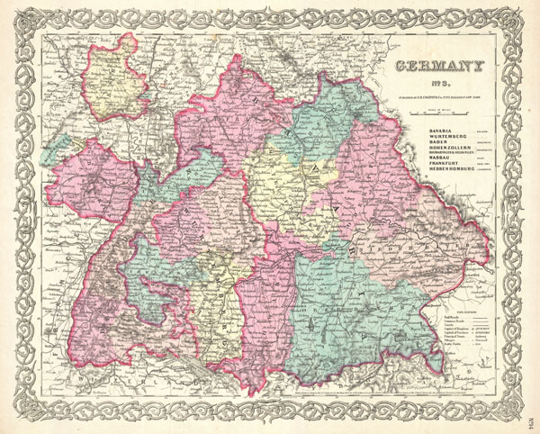
Germany No. 3.
sold
- Digital Map Information
- Suitable for large format printing
- File Size: 8.59 MB
- File Type: ZIP / TIFF
- ICC color profile embedded
- Delivered instantly via download link
A beautiful 1855 first edition example of Colton's map of southern Germany. Covers the 19th century German provinces of Bavaria, Wurttemberg, Baden and Pfalz, as well as numerous smaller regions. Divided and color coded according to regional divisions. ... (more details)

Germany No. 1.
sold
- Digital Map Information
- Suitable for large format printing
- File Size: 8.2 MB
- File Type: ZIP / TIFF
- ICC color profile embedded
- Delivered instantly via download link
A beautiful 1855 first edition example of Colton's map of northern Germany. Covers the 19th century German provinces of Hanover, Holstein, and Mecklenberg Schwerin. Divided and color coded according to regional divisions. An inset in the lower left ... (more details)

Holland and Belgium.
sold
- Digital Map Information
- Suitable for large format printing
- File Size: 7.8 MB
- File Type: ZIP / TIFF
- ICC color profile embedded
- Delivered instantly via download link
A beautiful 1855 first edition example of Colton's map of Holland and Belgium. Covers from Friesland to Luxembourg. Divided and color coded according to province. Insets in the upper left quadrant depict Amsterdam and Brussels. Throughout, Colton ... (more details)

Europe
sold
- Digital Map Information
- Suitable for large format printing
- File Size: 8.61 MB
- File Type: ZIP / TIFF
- ICC color profile embedded
- Delivered instantly via download link
A beautiful 1855 first edition example of Colton's map of Europe. Covers the entire continent from the Caspian Sea to Portugal, including the British Isles and Iceland. Throughout, Colton identifies various cities, towns, forts, rivers and ... (more details)

Comparative Size of Lakes and Islands.
sold
- Digital Map Information
- Suitable for large format printing
- File Size: 7.96 MB
- File Type: ZIP / TIFF
- ICC color profile embedded
- Delivered instantly via download link
A beautiful 1855 first edition example of Colton's curious topical chart of the world's great islands and lakes. Divided into lakes and islands of the Eastern and Western Hemispheres. Curiously does not include Greenland - who's northern ... (more details)

Switzerland.
sold
- Digital Map Information
- Suitable for large format printing
- File Size: 10.64 MB
- File Type: ZIP / TIFF
- ICC color profile embedded
- Delivered instantly via download link
A beautiful 1855 first edition example of Colton's map of Switzerland. Color coded according to canton. Throughout, Colton identifies various cities, towns, rivers and assortment of additional topographical details. Surrounded by ... (more details)

Denmark.
sold
- Digital Map Information
- Suitable for large format printing
- File Size: 9.54 MB
- File Type: ZIP / TIFF
- ICC color profile embedded
- Delivered instantly via download link
A beautiful 1855 first edition example of Colton's map of Denmark. Color coded according to region. Features three inset maps. Upper right hand inset details Iceland. Two insets in the lower left quadrant detail the Faroe ... (more details)

France.
sold
- Digital Map Information
- Suitable for large format printing
- File Size: 9.54 MB
- File Type: ZIP / TIFF
- ICC color profile embedded
- Delivered instantly via download link
A beautiful 1855 first edition example of Colton's map of France. Color coded according to departments. An inset map in the lower left quadrant details the Corsica. Throughout, Colton identifies various cities, towns, ... (more details)

Spain and Portugal.
sold
- Digital Map Information
- Suitable for large format printing
- File Size: 8.97 MB
- File Type: ZIP / TIFF
- ICC color profile embedded
- Delivered instantly via download link
A beautiful 1855 first edition example of Colton's map of Spain and Portugal. Color coded according to provincial divisions. An inset map in the upper right quadrant details the Gibraltar. Throughout, Colton ... (more details)

Scotland.
sold
- Digital Map Information
- Suitable for large format printing
- File Size: 10.35 MB
- File Type: ZIP / TIFF
- ICC color profile embedded
- Delivered instantly via download link
A beautiful 1855 first edition example of Colton's map of Scotland. Color coded according county. An inset map in the upper right quadrant details the Orkney Isles and another inset in the lower left ... (more details)
Made after San Francisco earthquake and fire of April 18th, 1906.
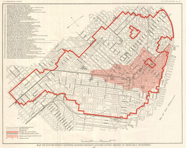
Map of San Francisco Showing Burned District; Accompanying Report of Richard L. Humphrey.
sold
- Digital Map Information
- Suitable for large format printing
- File Size: 4.49 MB
- File Type: ZIP / TIFF
- ICC color profile embedded
- Delivered instantly via download link
An unusual map of San Francisco, California, dating to 1907. This map was published by the U.S. Geological Survey following the terrible San Francisco Earthquake and Fire of 1806. This natural ... (more details)
Made after San Francisco earthquake and fire of April 18th, 1906.
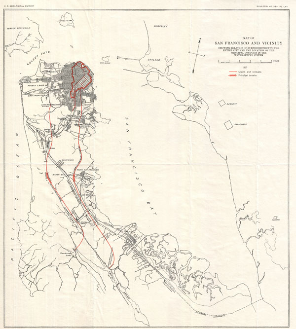
Map of San Francisco and Vicinity Showing Relation of Burned District to the Entire City and the Location of the Principal Conduits in the Water-Suppy System.
sold
- Digital Map Information
- Suitable for large format printing
- File Size: 20.19 MB
- File Type: ZIP / TIFF
- ICC color profile embedded
- Delivered instantly via download link
An unusual map of San Francisco Peninsula and part of San Francisco Bay dating to 1907. This map was published by the U.S. Geological Survey following the terrible San Francisco Earthquake and ... (more details)
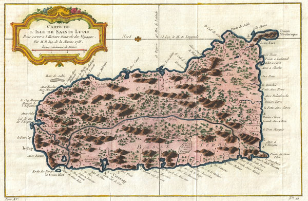
Carte de L'Isle de Sanite Lucie.
sold
- Digital Map Information
- Suitable for large format printing
- Full resolution TIFF file
- ICC color profile embedded
- Delivered instantly via download link
An extremely attractive example of Bellin's rare 1758 map of Saint Lucia (St. Lucia) or Sainte Lucie in the West Indies. St. Lucia is considered to be one of the most beautiful of the Windward ... (more details)

Greece and the Ionian Republic.
sold
- Digital Map Information
- Suitable for large format printing
- File Size: 9.66 MB
- File Type: ZIP / TIFF
- ICC color profile embedded
- Delivered instantly via download link
A beautiful 1855 first edition example of Colton's map of Greece. Covers from Corfu to Thera and Lesbos. Color coded according to region. Throughout, Colton identifies various cities, ... (more details)

Asia.
sold
- Digital Map Information
- Suitable for large format printing
- File Size: 8.4 MB
- File Type: ZIP / TIFF
- ICC color profile embedded
- Delivered instantly via download link
A beautiful 1855 first edition example of Colton's map of Asia. Covers from the Mediterranean to Siberia and from the Arctic to Singapore. Color coded according to regions. Includes ... (more details)

China.
sold
- Digital Map Information
- Suitable for large format printing
- File Size: 7.48 MB
- File Type: ZIP / TIFF
- ICC color profile embedded
- Delivered instantly via download link
A beautiful 1855 first edition example of Colton's map of China, Korea, and Taiwan. Covers from Mongolia to Hainan and from Tibet to Korea. Color coded according to various provinces ... (more details)