
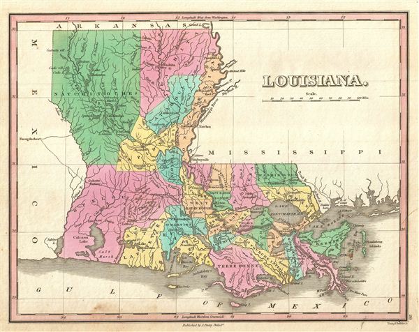
Louisiana
sold
- Digital Map Information
- Suitable for large format printing
- DPI: 300
- File Size: 3.27 MB
- File Type: ZIP / TIFF
- ICC color profile embedded
- Delivered instantly via download link
A beautiful example of Finley's important 1827 map of Louisiana. Shows early county configuration. Depicts the state with moderate detail in Finley's classic minimalist style. Shows river ways, roads, canals, and some topographical features. Offers color coding ... (more details)

North America.
sold
- Digital Map Information
- Suitable for large format printing
- DPI: 300
- File Size: 4.34 MB
- File Type: ZIP / TIFF
- ICC color profile embedded
- Delivered instantly via download link
This is Finley's desirable 1827 map of the North America. Covers the continent from Panama to the Arctic Circle, including Greenland, Iceland, and the northwestern tip of Asia. Color coding according to country. Shows U.S. claims to British Columbia prior to ... (more details)

The World on Mercator's Projection.
sold
- Digital Map Information
- Suitable for large format printing
- DPI: 300
- File Size: 3.72 MB
- File Type: ZIP / TIFF
- ICC color profile embedded
- Delivered instantly via download link
This is Finley's desirable 1827 map of the World. Covers the entire world on a Mercator Projection. Identifies deserts, rivers, many countries, and numerous cities. Color coded according to continent with Australia (New Holland) attached to Asia. Does not ... (more details)
Includes the Great Lakes.

Canada.
sold
- Digital Map Information
- Suitable for large format printing
- DPI: 300
- File Size: 3.35 MB
- File Type: ZIP / TIFF
- ICC color profile embedded
- Delivered instantly via download link
This is Finley's desirable 1827 map of Canada. Covers the Upper Canada (Ontario) and Lower Canada (Quebec), New Brunswick, Nova Scotia, and all five of the Great Lakes. Names numerous American Indian Nations throughout. Also identifies the 'Three Rivers' ... (more details)

United States.
sold
- Digital Map Information
- Suitable for large format printing
- DPI: 300
- File Size: 3.72 MB
- File Type: ZIP / TIFF
- ICC color profile embedded
- Delivered instantly via download link
This is Finley's desirable 1827 map of the United States. Covers the United States as it existed in 1827, extending westward as far as the Missouri Territory, Arkansas Territory, and Mexico. Identifies rivers, mountain ranges, lakes, and major cities. ... (more details)

Eastern Hemisphere.
sold
- Digital Map Information
- Suitable for large format printing
- DPI: 300
- File Size: 3.86 MB
- File Type: ZIP / TIFF
- ICC color profile embedded
- Delivered instantly via download link
This is Finley's desirable 1827 map of the Eastern Hemisphere. Includes Africa, Europe, Asia and Australia. Identifies deserts, rivers, mountain rangers, lakes, and major cities. Color coded according to continent. Australia is included with Asia. ... (more details)

West Indies.
sold
- Digital Map Information
- Suitable for large format printing
- DPI: 300
- File Size: 3.9 MB
- File Type: ZIP / TIFF
- ICC color profile embedded
- Delivered instantly via download link
This is Finley's desirable 1827 map of the West Indies and Caribbean. Shows the Greater and Lesser Antilles as well as the Bahamas and portions of the Spanish Main. Islands are color coded according to their European claimants. Shows cities, forts, ... (more details)

Scotland.
sold
- Digital Map Information
- Suitable for large format printing
- DPI: 300
- File Size: 3.95 MB
- File Type: ZIP / TIFF
- ICC color profile embedded
- Delivered instantly via download link
This is Finley's desirable 1827 map of Scotland. Shows river ways, roads, canals, and some topographical features. Color coding defines traditional county divisions. Mile scales and title in upper right quadrant. Engraved by Young and Delleker for ... (more details)

Ireland.
sold
- Digital Map Information
- Suitable for large format printing
- DPI: 300
- File Size: 3.88 MB
- File Type: ZIP / TIFF
- ICC color profile embedded
- Delivered instantly via download link
This is Finley's desirable 1827 map of Ireland. Shows river ways, roads, canals, and some topographical features. Color coding defines all four provinces as well as the numerous traditional county divisions. Mile scales and title in upper left ... (more details)

Maine.
sold
- Digital Map Information
- Suitable for large format printing
- DPI: 300
- File Size: 3.25 MB
- File Type: ZIP / TIFF
- ICC color profile embedded
- Delivered instantly via download link
A beautiful example of Finley's important 1827 map of Maine and possibly the most interesting of the this series. Shows early county configuration. Depicts the state with moderate detail in Finley's classic minimalist style. Shows river ways, ... (more details)
Depicts Chickasaw and Choctaw Territory just prior to Trail of Tears.
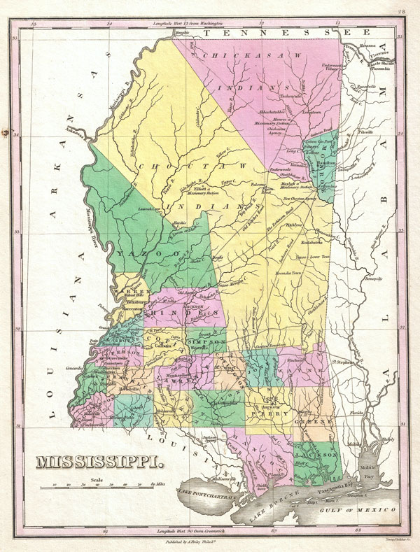
Mississippi.
sold
- Digital Map Information
- Suitable for large format printing
- DPI: 300
- File Size: 3.07 MB
- File Type: ZIP / TIFF
- ICC color profile embedded
- Delivered instantly via download link
A beautiful example of Finley's important 1827 map of Mississippi. Depicts the state with moderate detail in Finley's classic minimalist style. Shows river ways, roads, canals, and some topographical features. Offers color coding at the county ... (more details)

Ohio.
sold
- Digital Map Information
- Suitable for large format printing
- DPI: 300
- File Size: 3.43 MB
- File Type: ZIP / TIFF
- ICC color profile embedded
- Delivered instantly via download link
A beautiful example of Finley's important 1827 map of Ohio. Includes much of Lake Erie. Depicts the state with moderate detail in Finley's classic minimalist style. Shows river ways, roads, canals, and some topographical features. Offers ... (more details)
Important American Indian westward migration map.
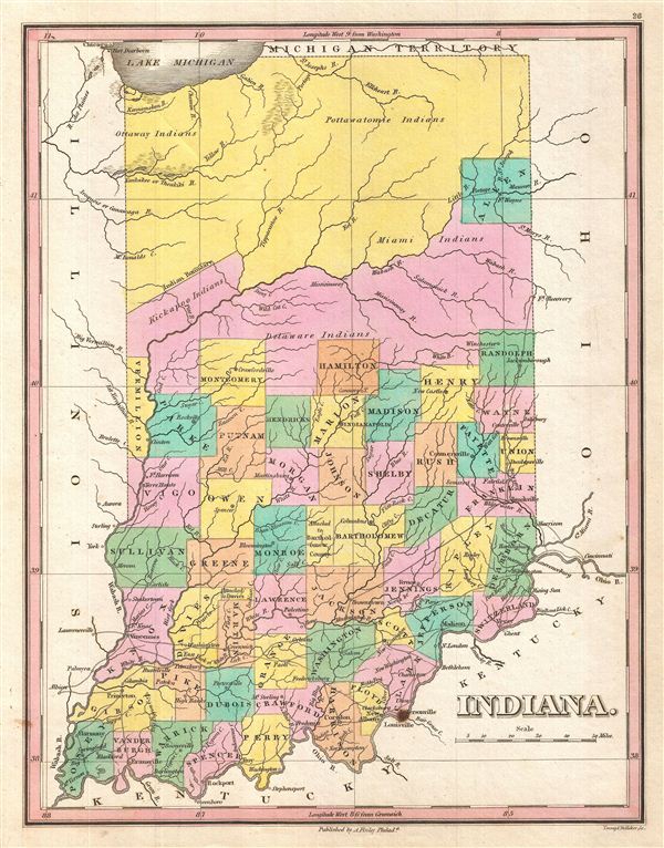
Indiana.
sold
- Digital Map Information
- Suitable for large format printing
- DPI: 300
- File Size: 3.45 MB
- File Type: ZIP / TIFF
- ICC color profile embedded
- Delivered instantly via download link
A beautiful example of Finley's important 1827 map of Indiana. Depicts the state with moderate detail in Finley's classic minimalist style. Shows river ways, roads, canals, and some topographical features. Offers color coding at the county ... (more details)

New York.
sold
- Digital Map Information
- Suitable for large format printing
- DPI: 300
- File Size: 3.45 MB
- File Type: ZIP / TIFF
- ICC color profile embedded
- Delivered instantly via download link
A beautiful example of Finley's important 1827 map of New York. Includes Long Island and Lake Ontario. Depicts the state with moderate detail in Finley's classic minimalist style. Shows river ways, roads, canals, and some topographical ... (more details)

Virginia.
sold
- Digital Map Information
- Suitable for large format printing
- DPI: 300
- File Size: 3.59 MB
- File Type: ZIP / TIFF
- ICC color profile embedded
- Delivered instantly via download link
A beautiful example of Finley's important 1827 map of Virginia. Includes Washington D.C. or the District of Columbia. Depicts the state, which includes modern day West Virginia, with moderate detail in Finley's classic minimalist ... (more details)

New Hampshire.
sold
- Digital Map Information
- Suitable for large format printing
- DPI: 300
- File Size: 3.53 MB
- File Type: ZIP / TIFF
- ICC color profile embedded
- Delivered instantly via download link
A beautiful example of Finley's important 1827 map of New Hampshire. Depicts the state with moderate detail in Finley's classic minimalist style. Shows river ways, roads, canals, and some topographical features. Offers color ... (more details)
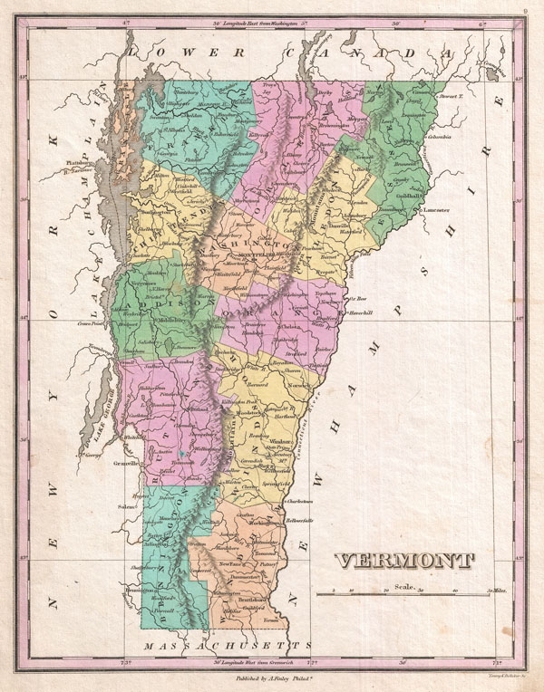
Vermont.
sold
- Digital Map Information
- Suitable for large format printing
- Full resolution TIFF file
- ICC color profile embedded
- Delivered instantly via download link
A beautiful example of Finley's important 1827 map of Vermont. Depicts the state with moderate detail in Finley's classic minimalist style. Shows river ways, roads, canals, and some topographical features. Offers color coding ... (more details)
Rare singular map of Connecticut.

Connecticut.
sold
- Digital Map Information
- Suitable for large format printing
- DPI: 300
- File Size: 3.59 MB
- File Type: ZIP / TIFF
- ICC color profile embedded
- Delivered instantly via download link
A beautiful example of Finley's important 1827 map of Connecticut. Depicts the state with moderate detail in Finley's classic minimalist style. Shows river ways, roads, canals, and some topographical features. Offers color ... (more details)
Rare singular map of Rhode Island.

Rhode Island.
sold
- Digital Map Information
- Suitable for large format printing
- DPI: 300
- File Size: 2.96 MB
- File Type: ZIP / TIFF
- ICC color profile embedded
- Delivered instantly via download link
A beautiful example of Finley's important 1827 map of Rhode Island. Includes Block Island. Depicts the state with moderate detail in Finley's classic minimalist style. Shows river ways, roads, canals, and some ... (more details)
Depicts Cherokee Territory just prior to Trail of Tears.

Tennessee.
sold
- Digital Map Information
- Suitable for large format printing
- DPI: 300
- File Size: 2.87 MB
- File Type: ZIP / TIFF
- ICC color profile embedded
- Delivered instantly via download link
A beautiful example of Finley's important 1827 map of Tennessee. Depicts the state with moderate detail in Finley's classic minimalist style. Shows river ways, roads, canals, and some topographical features. ... (more details)