Hysterical Maps of the Lindgren Brothers: A Cartobibliography
An Evolving Cartobibliography
Geographicus Rare Antique Maps cartobibliography of the Lindgren Brothers Hysterical Map Series, cataloging their map output from roughly 1932 - 1950.
by Kevin J. Brown • July 02, 2025
Starting in 1932, the Lindgren Brothers of Spokane, Washington, began issuing medium-format pictorial maps, mostly of national parks, which they dubbed 'Hysterical.' The maps were doubtless influenced by the comparable work of American mapmakers Jo Mora and Harrison Godwin, as well as international figures like MacDonald Gill. Lindgren maps were simply illustrated with primary colors and lighthearted content, meant to get a laugh or at least a raised eyebrow. They emerged in the Interwar Period (1918 - 1939), an era defined by the breakdown of social structure, widespread disillusionment, the Great Depression, industrialization, and breakneck technological advances. In the United States, spurred by the ease of movement brought about by the automobile, infrastructure investment by New Deal programs, escapism into nature, and affordability, a nationwide love affair with our National Parks emerged - and remains. The Lindgrens capitalized on this unique situation to introduce an affordable, mailable souvenir - the Hysterical Map. Both visually striking and funny, the Hysterical Map could be framed and displayed as a happy momento or folded and mailed to friends and family. The Lindgrens made maps of most of the Great National Parks, as well as other points of interest, though they kept a broad focus on the Western United States. Hysterical Maps remained in production until about 1954.
Lindgren's earliest maps issued in 1932-33 were printed in multiple colors via photographic multi-layered silkscreen stencils, a laborious process that, while they did not invent, they did pioneer. (Lindgren was likely introduced to the technique while serving in Europe during World War I). According to business partner Ted Turner Jr., they used Swiss sieve silk acquired from a local flower mill supply company. The paint was regular house paint, doctored to achieve the right consistency with a proprietary blend of starch, vinegar, and kerosene. The paint blend was applied in layers, with colors applied first, then black ink, each color pressed through the open stencil mesh using a squeegee blade. The result was replicable (in small numbers) prints in striking, vibrant colors.
The use of silkscreen printing on Lindgren's initial map productions introduced elements that became synonymous with Lindgren's style - bold colors, simple print blocks, and thick lines.
The Lindgren brothers, based in Spokane, Washington, were known for producing lighthearted, cartoon-style pictorial maps of state and national parks. Their enterprise began as a sign painting business in 1928, with Hjalmer' 'Jolly' Lindgren serving as the illustrator and Oscar (O.S.) Lindgren managing operations and production.
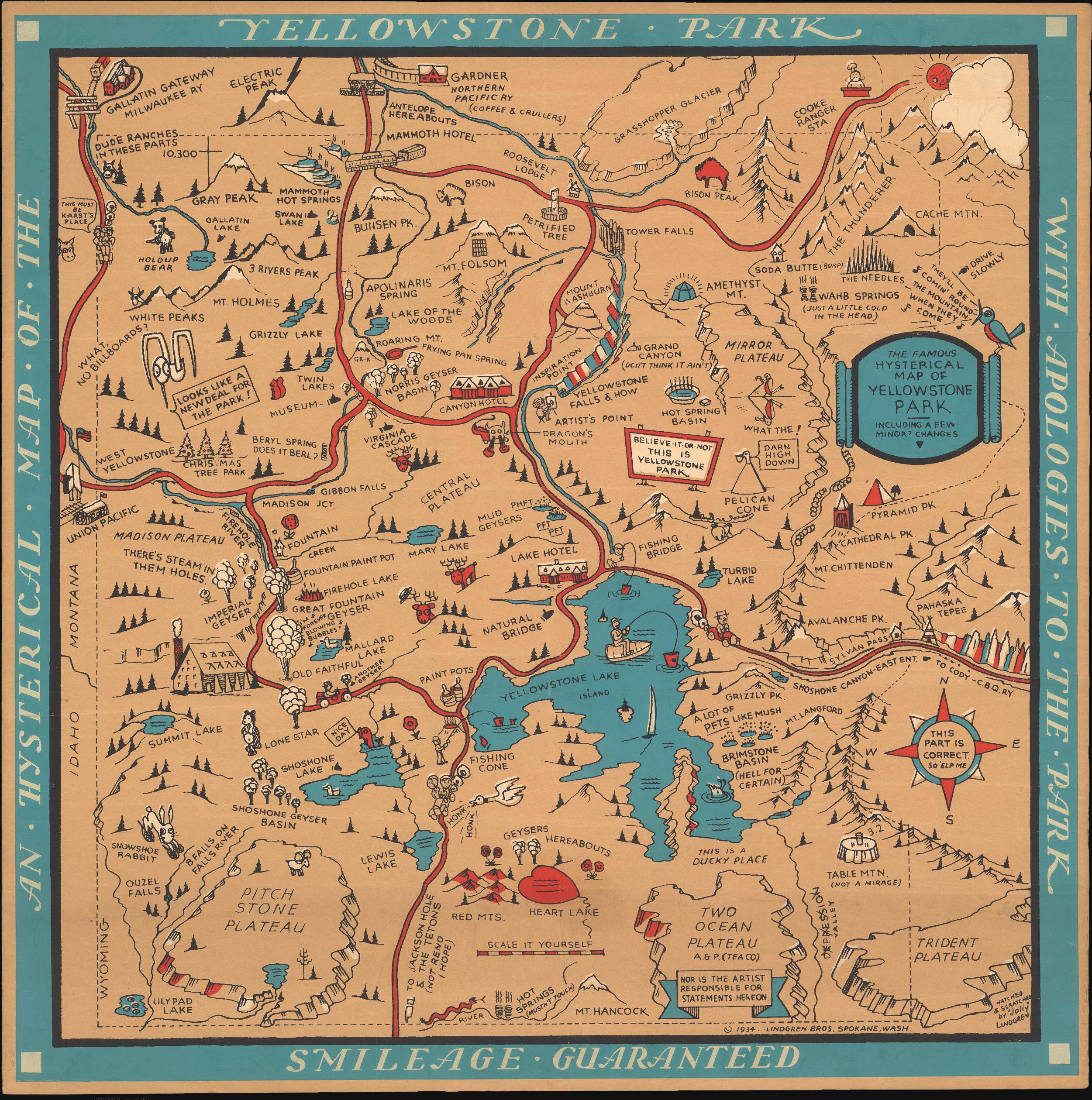
Their first map, titled Hysterical Map of the Spokane Country Slightly Cockeyed, was screen printed in 1932. As the name suggests, it was designed to entertain rather than inform, aiming more for humor than historical accuracy. The map's popularity led to additional titles in 1933, all in partnership with local advertising man Lee R. Double: Eastern Washington County, Puget Sound County, Mount Rainier, and Olympic Peninsula and Puget Sound Country. Then, in 1934, they issued their groundbreaking Yellowstone National Park, the first to feature their trademark blue border.
Although the Great Depression strained many industries, national park tourism flourished. The Lindgren Brothers successfully tapped into this market by offering humorous, souvenir-style maps to eager visitors. Starting with the 1934 Yellowstone release, Jolly introduced a consistent visual template that became his hallmark: a bold blue (or red) border featuring the title, yellow to represent land (a nod to Yellow-stone), red for roads, black for labels, and touches of green and blue to accent the illustrations.
In 1930, the Lindgrens brought on Theodore 'Ted' Turner, Jr. (1902 - 1989) as sales director - it was Turner's clever idea to change the name of their 'slightly cockeyed' maps from 'Historical' to 'Hysterical'. Over the years, his involvement deepened, and by 1949, he became a full partner, and the company was renamed Lindgren-Turner.
Following World War II, as interest in humorous maps declined, the team pivoted to producing souvenir decals, which proved extremely popular. After Jolly Lindgren's death in 1952, Oscar and Turner continued to expand the company's offerings, introducing oversized map-themed postcards branded as 'King Size Mapcards.'
In any list or collection of Lindgren Brothers Hysterical Maps, it is essential to distinguish between those that were hand-silkscreened and those that were machine printed. Often, the difference is clear even to the untrained eye; other times, it is less so - generally, when not initially obvious, silkscreened maps feature richer color, and it is possible to feel the 'texture' of the layered paint. Likewise, defining an 'edition' is difficult and, in some cases, impossible. The most popular Hysterical Maps, such as Yellowstone, were printed in both silkscreen and machine presses, as well as in a variety of color configurations. Likely, the 1936 issues, to follow through with our Yellowstone example, continued to be issued well after that date using a variety of printing techniques due to their extreme popularity. Even within the narrow limits of those maps that were silkscreened, we can trace an evolution of the printing techniques as the Lindgren Brothers refined their processes and gained access to higher-quality paints, screens, and papers. Nor is it clear that they ever fully gave up on silkscreening. Some of their later maps may have been silkscreened in the initial phase of production and then transitioned to mechanical printing. Other maps give no evidence of having ever been silkscreened, though it is not impossible that proofs or early examples may yet emerge. For collectors interested in adding 'value' to their collections, silkscreened examples must be considered to be of the highest rarity and the gold standard, thus receiving a correspondingly higher market consideration.
While several articles and blog posts have been written about the Lindgren Brothers and their Hysterical Maps, no attempt that we are aware of has been made at a complete list of all Hysterical Maps. This Geographics Blog post attempts to address this issue. It necessarily focuses exclusively on the Hysterical Map series and does not attempt to address their considerable postcard and decal production. It is an evolving project, and we expect more editions and maps to come to our attention over time.
The following references have been instrumental in informing this ongoing work:
- Spokane brothers dominated the market for national park maps – The Spokesman-Review
- The Hysterical Maps of the Lindgren Brothers – Barron Maps
- That’s Just Hysterical! The Lindgren Brothers’ Tourist Maps – Library of Congress Blog
- David Rumsey Map Collection
- Clinton, Craig, 'Hysterical Maps - The cock-eyed maps of the Lindgren Brothers', IMCOS Journal, #125 [Summer 2011], pp. 27–39.
Related Posts and Information
overall rating:
my rating:
log in to rate
Recent Posts
Hysterical Maps of the Lindgren Brothers: A Cartobibliography
Mapmaker in Focus: Edward Spofford, inventor of the Supervue
How to Frame Antique Maps
Gordon-Michael Scallion's Doomsday Maps
The Most Successful 16th Century Geographic Fraud
W. H. Whitney Maps of Railroad Cities
Categories
Cartographer Posts
Cartographic Themes
Map How-To
all
Archives
January, 2025
December, 2024
January, 2024
December, 2023
January, 2023
archive article list