The Most Successful 16th Century Geographic Fraud
The Greatest Phantom Island of the Old World.
Nicoló Zeno the Younger's attempt to co-opt Columbus's 1492 discovery of America and reattribute that feat to his own ancestors, Nicoló and Antonio Zeno. The Zeno mapping of the Arctic proved to be one of the most enduring cartographic frauds, persisting from the 16th through the 18th centuries - and beyond.
by James Roy • December 01, 2023
It doesn't take long, in exploring old maps, to realize there are many instances where the map does not accurately reflect the actual lay of the land. Borders change, or have varying interpretations, or are sometimes just wrong. Topography can be misunderstood, or imaginary. There are many instances of mapmakers getting things wrong while acting in good faith. Sometimes, maps are produced whose errors can only construed as deliberate. In both cases, it often happens that an erroneous map is then copied, sometimes repeatedly over decades upon decades. From a traveler's point of view, or an explorer's, this can be a disaster. From a collector's point of view, this can be very interesting.
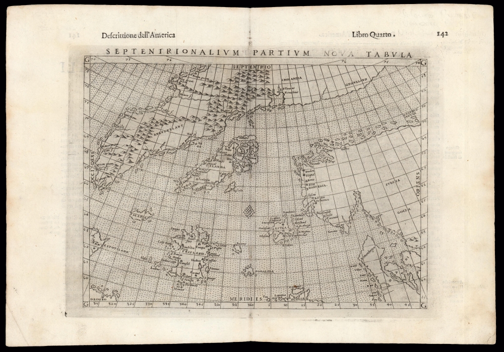
In 1558, a powerful Venetian politician - Nicolo Zeno - published "anonymously" a pamphlet containing several letters and a map, purporting to have been preserved correspondence from two of Zeno's ancestors: Venetian merchants and adventurers Nicolo and Antonio Zeno, who lived in the 14th century. The letters describe the adventures of Nicolo and Antonio in seas of the north, which take them to Iceland, Greenland and most notably to the islands of Frisland and Icaria; Iceland and Greenland were known to travelers. However, no one had ever seen or heard of Frisland or Icaria. Also reported, secondhand in the account, are the lands of Estotiland and Drogeo. The map accompanying the letters presented these discoveries unambiguously, which was an astonishment - not least because Frisland and Icaria, Estotiland and Drogeo do not and did not exist. The Zeno map of 1558 is now unobtainable but it got its broadest dissemination in the 1561 Ruscelli edition Ptolemy's Geography, editions of which are relatively easy to acquire, particularly in its later editions.
The map is a faithful copperplate copy of the 1558 woodcut, with the significant difference that Greenland and Scandinavia are shown as separate landmasses: the 1558 connects them, which was a conception typical of maps of the north parts of the world in the first half of the 16th century. Greenland dominates the north extent of the map. The eastern coast of Estotiland appears in the southwest (it later was thought to be part of Labrador) and the coast of Drogeo appears further south (later geographers thought this to be Newfoundland.) Iceland appears near the center of the map; to its southwest lie the phantom islands of Icaria and Frisland. Exploration eventually revealed the Zeno map to be incorrect and subsequent analysis of the map and its sources revealed the entire Zeno narrative to be fraudulent. (Fred W. Lucas' 1898 "The Voyages of the Brothers Zeni" is a gleeful and adept destruction of the myth.) But upon its publication, Zeno's map was taken at face value and embraced as genuine by no lesser lights than Mercator and Ortelius; thus, despite its presentation of false geography, it was hugely influential.
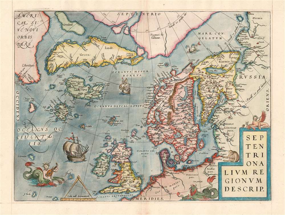
This is Ortelius' map of the north Atlantic, showing how Zeno's geographical fraud took hold and influenced the broader mapmaking establishment. Ortelius has fully digested the data of the above map, and incorporated it into Mercator's treatment of the Arctic, northern Europe, and the Canadian Maritimes. Here, Ortelius expresses what the Zeno only implied - Estotiland is part of Labrador. This map was engraved in 1570; this one is a 1574 printing. It is presented on a different projection, and includes a more modern and accurate delineation of the British Isles and Scandinavia, but the Zeno geography - Greenland, Iceland, Frisland, Icaria, Drogeo and Estotiland - are preserved. Ortelius explicitly presents Estotiland as part of America.
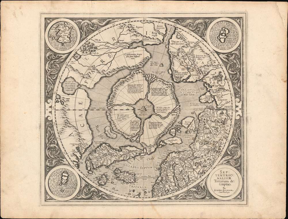
Ortelius derived most of his northern geography from Mercator's world map of 1569; Mercator himself would not produce a full atlas in his lifetime but in 1595 his sons published his posthumous work. It contained the first state of the geographers' polar projection, which is extremely rare (priced accordingly): You can see here how it incorporates, with his own arctic regions, the by-now-ubiquitous Zeno geography.
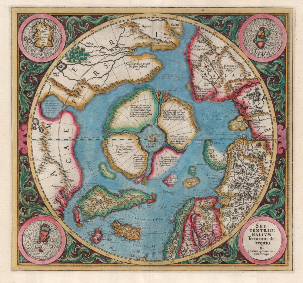
Mercator's sons did another edition of the atlas in 1602, but thereafter the plates were purchased by Jodocus Hondius. Hondius added many plates of his own, but ran most of the Mercator maps without change. The Arctic map was an exception: between 1595 and 1606, the Barentz expedition redefined the geography, and Hondius amended the Mercator to reflect a more state of the art understanding of the oceans north of Europe and Russia. This second state of the map is much more acquirable than the first, as it remained in the Hondius atlas into the 1630s.
The Zeno geography screwed everyone up for a century. Martin Frobisher, sighting the south coast of Greenland, believed he saw Frisland, and claimed it for England. Frisland and Estotiland show up on maps well into the 17th century; even after it was agreed that Frisland did not exist, other phantom islands appeared to take its place. And it didn't end even after it became clear how wrong the Zeno map was with Zeno-defenders active will into the 20th century.Ironically, the best refutation of the Zeno hoax (Fred Lucas' 1898 work) was privately published in a small run, swiftly going out of print. Meanwhile, the 19th century supporters of the Zeno narrative (who saw it as evidence that America was discovered prior to Columbus, variously, by the Venetians or indeed by the Scottish) remained in print well into the 20th century. The unfortunate result being that later 20th-century scholarship on the Zeno map were informed by its most misguided proponents, without the benefit of Lucas' systematic destruction of their arguments. There are a number of tinfoil-hat narratives of the 1980s and even later that claim the Zeno map as the (sole) proof not only that America was visited by a Scottish earl in the 14th century, but that he brought the Knights Templar to North America. Lucas' book was reprinted until 2013, and while this is a fair representation of the text it lacks the critical facsimile maps of the 1898 original.
Related Posts and Information
overall rating:
my rating:
log in to rate
Recent Posts
Hysterical Maps of the Lindgren Brothers: A Cartobibliography
Mapmaker in Focus: Edward Spofford, inventor of the Supervue
How to Frame Antique Maps
Gordon-Michael Scallion's Doomsday Maps
The Most Successful 16th Century Geographic Fraud
W. H. Whitney Maps of Railroad Cities
Categories
Cartographer Posts
Cartographic Themes
Map How-To
all
Archives
January, 2025
December, 2024
January, 2024
December, 2023
January, 2023
archive article list