W. H. Whitney Maps of Railroad Cities
A Little-known Series of Important Early Maps of Western American Railroad Cities.
J. H. Whitney issued a his railroad maps between 1888 and 1890. They are rare and little known, but represent some of the earliest and most important maps of their respective subjects: Salt Lake City, Pueblo, Trinidad, Portland, Seattle, Port Townsend, Astoria, Spokane, Bellingham Bay.
by Kevin Brown • January 10, 2023
 Between 1888 and 1890 an important, little known, and curious serious of maps of Western and Pacific Northwestern cities were released with attribution to 'W. H. Whitney'. The maps were tied to railroad development in Colorado, Utah, Washington, Oregon, and thus represent some of the earliest and most important maps of their respective cites.
The earliest Whitney maps, illustrating Pueblo and Trinidad, Colorado, and Salt Lake City, Utah, were issued for the Denver and Rio Grande Railroad, and its subsidiaries, and bear those companies logos. Sometime in 1889, Whitney began to produce similar maps for the Union Pacific, and subsequent Whitney maps bear the Union Pacific logo. This first was his map of Portland, the only Whitney-UP map copyrighted to 1889.
Curiously, these maps focused heavily on major cities and railroad connections in the Pacific Northwest, of which, only Portland was served by the Union Pacific. Nonetheless, through a series of co-shares and leases with the ostensibly competing Great Northern and Northern Pacific, the Union Pacific achieved deep penetration into the Pacific Northwest, reaching Tacoma, Port Townsend, Astoria, Bellingham Bay, and Spokane - all of which are represented by Whitney maps.
The maps incorporate city plans, cadastral data, real estate promotion, and railroad routes. While all bear the Whitney imprint, as well as a railroad logo, some also feature local businesses, which vary between examples, suggesting that advertising space was sold. Most are co-attributed to local civil engineers, many of whom worked for the railroads. Whitney, himself, was more of a compiler and draftsman, bringing uniformity to the project, rather than an on-site cartographer. With the exception of Pueblo, Colorado, all Whitney maps were printed by Lewis Humphrey Everts in Philadelphia. Some of the maps were either re-published or co-published under the name of the local civil engineer, such as 'Anderson's Map of Seattle'.
The identity of Whitney is a mystery. 'Whitney' was a common name, and 'W.H.' does little to shed light. He appears in none of the period directories of the cities represented by 'Whitney' maps. Nor is he named in available Union Pacific reports. With limited success, we have argued that this may be William Henry Whitney (1843 - 1909). That Whitney, after 1888, owned a private civil engineering, surveying, and mapmaking firm in Boston. While certainly capable of drafting the present maps, they are incongruous with his other work, most of which focuses on the Boston Back Bay development. That being said, there does appear to be a gap in Whitney's career between 1888 and 1890, when he might have taken the railroad contracts.
Cartobibliography
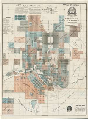
Map of Pueblo, Pueblo County, Colorado.
This is c. 1888 map of Pueblo, Colorado, the 'Pittsburg of the West' is Whitney's first map in his western railroad series. While aesthetically similar to latter maps in the series, this one stands out for being published by the Denver Lithographing Company, rather than L. H. Everts of Philadelphia. Moreover, although undated, the map is one of just three issued for the Denver and Rio Grande Railroad. Others include Trinidad (we have been unable to source an image of this one) and Salt Lake City.

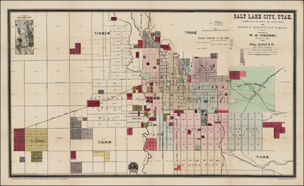
Salt Lake City, Utah.
This map of Salt Lake City is most likely Whitney's second map. It is the first to have been printed in Philadelphia by Louis Humphrey Everts and bears the ephemeral imprint of the Rio Grande Western Railroad. The 'RGW' was a short-live subsidiary of the Rio Grande Railway split off in 1888 to help finance track upgrades on the Salt Lake - Ogden line. The RGW was reabsorbed into the Denver Rio Grande Railroad in 1889.
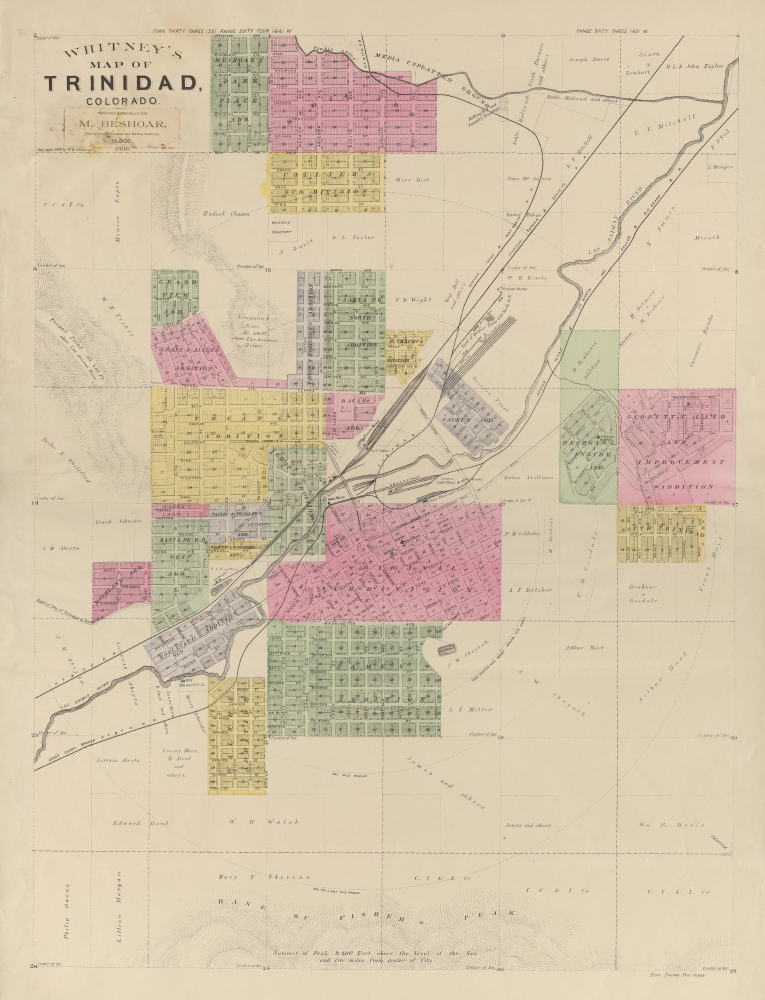
Whitney's Map of Trinidad, Colorado.
Whitney's 1888 map of Trinidad, Colorado, is the rarest and most unusual map of the series. It has an unfinished quality to it, bearing no railroad logo and having no printer's imprint. Moreover, unlike all others, there is no defined outer border. This may be that the example we have here is a proof, and more sophisticated versions were issued, that it was made on a shoestring budget, or that it was unfinished.
This map presents Trinidad as a major railroad hub. We see lines for three major railroads: the 'Denver Rio Grande', the 'Atchison, Topeka and Santa Fe', and the 'Denver, Texas and Fort Worth' (shared tracking with the Union Pacific). Note the Union Passenger Terminal near center. At the time, like many Colorado towns, Trinidad was enjoying a major population boom. Its location at the juncture of several major railroads transformed it into a important cattle town. Later, it became known for its immense coal deposits.
A pastedown near the title states that the map was 'Prepared Exclusively for M. Beshoar'. This would be Dr. Michael Beshoar (1833 - 1907), an prominent physician, politician, and newspaper publisher active in Trinidad from 1867 to his death in 1907. Beshoar was a well traveled and accomplished individual who has the unique distinction have having served first in the Confederate, then in the Union armies.
Image courtesy of the University of Colorado, Boulder G4314.T7P2 1888 .W4.
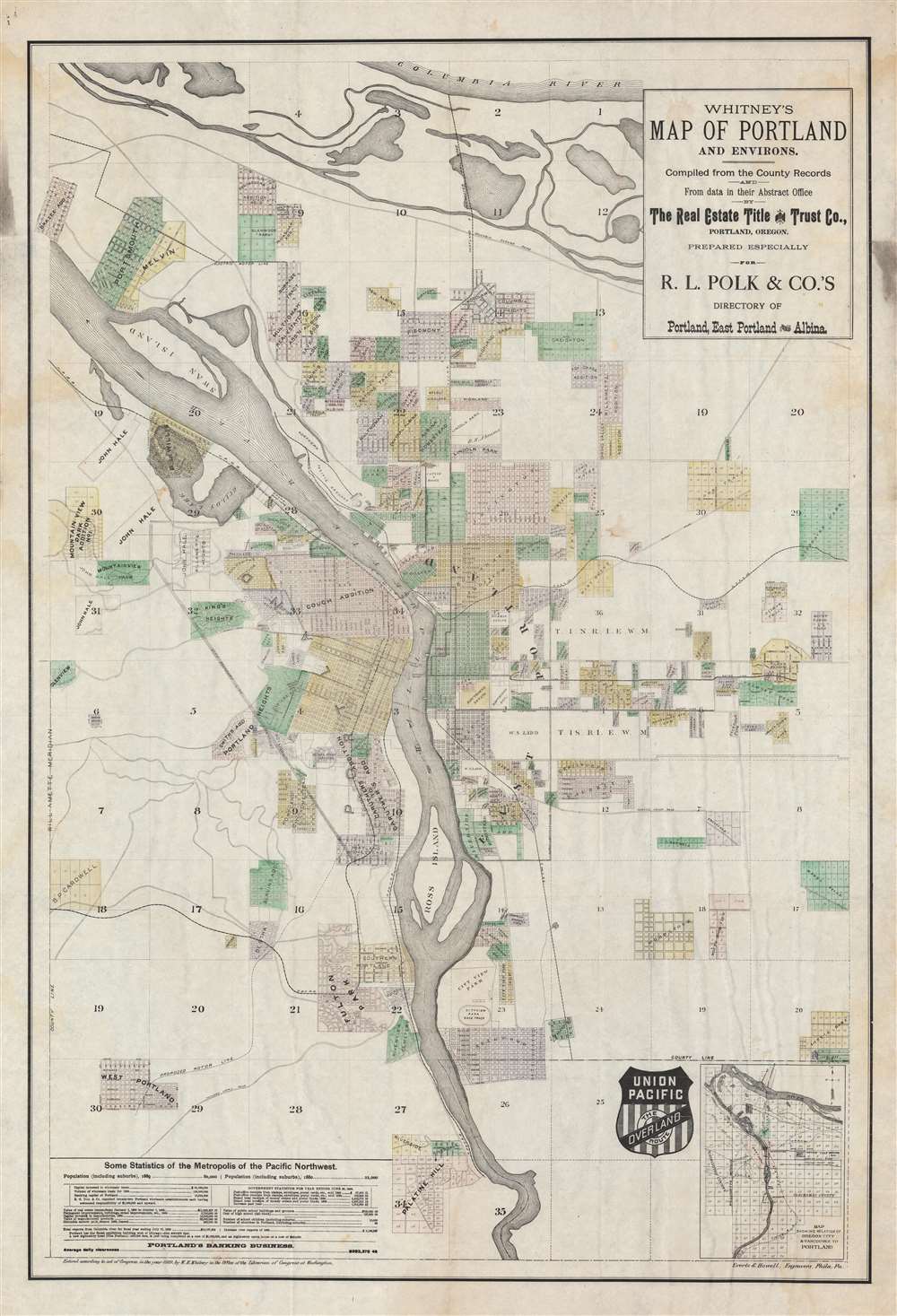
Whitney's Map of Portland and Environs.
Published in 1889, this is the first Whitney map to bear the Union Pacific logo. Apparently, having achieved some success with the Denver Rio Grande, his work caught the attention of the much larger Union Pacific. Portland, at the time criticized as a 'Mud Town', was the first Pacific Northwest city to be served by the Union Pacific. To compete with the Northern Pacific, the UP acquired the Oregon Railway and Navigation lines, shown here, finally connecting in 1884.
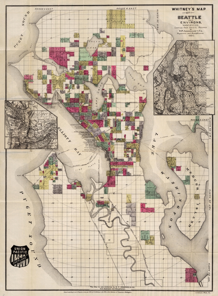
Whitney's Map of Seattle and Environs, Washington.
Whitney's map of Seattle is likely his first map of 1890. At the time, Seattle was a prominent ferry town, with limited connections to transcontinental service, all of which ran through Tacoma. Seattle was moreover, devastated by the 1889 Great Seattle Fire, which destroyed much of the downtown. Shortly afterwards, the railroad tycoon Henry Villard (1835-1900) regained control of Northern Pacific with commitments to link directly to Seattle. In 1890, Villard purchased majority shares of the the Seattle Lake Shore and Eastern, renovated and expended the line, and finally linked Seattle directly to the Northern Pacific, bypassing Tacoma. Two years later, in 1892, the Northern Pacific built passenger station on Railroad Avenue between Madison and Columbia streets.
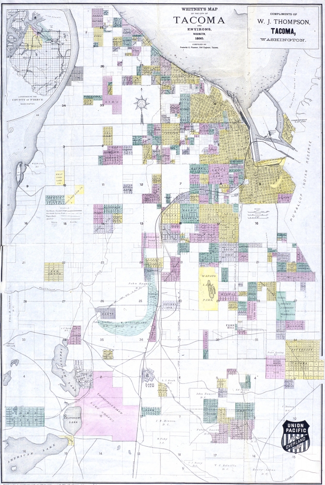
Whitney's Map of the City of Tacoma and environs, Washington.
Whitney's 1890 map of Tacoma is one of the rarest maps in this series. In 1873, despite being little more than a village, Tacoma was selected over Seattle as the terminus of the Northern Pacific Railroad. Railroad engineers and investors picked Tacoma because (a) it was closer to the Columbia River and (b) required the less track to reach. In 1889 - 1890 a new line was opened directly to more established port of Seattle, partially sidelining Tacoma.
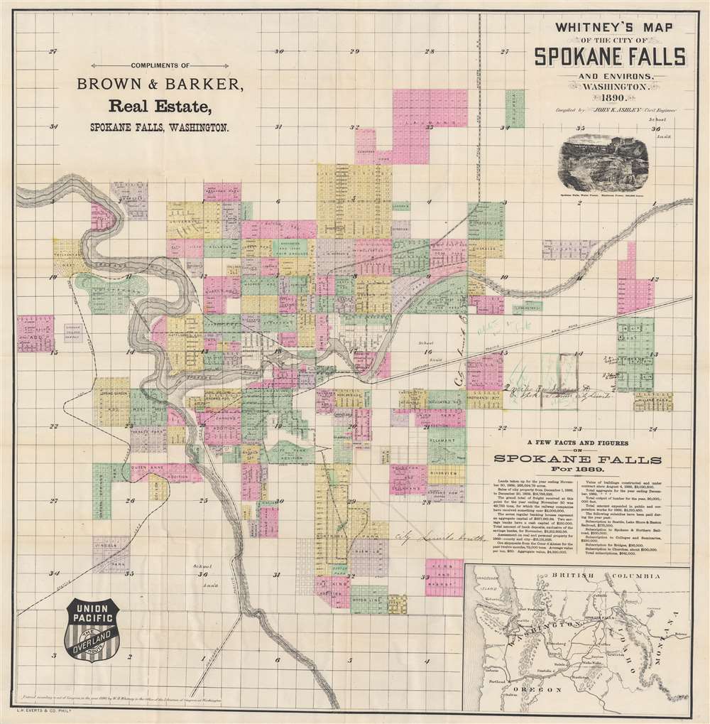
Whitney's Map of the City of Spokane Falls and Environs, Washington.
Whitney's map of 1890 Spokane Falls is the last of his maps to illustrate a town directly on the Northern Pacific Line. The first railroad reached Spokane in 1881, running only a short distance from Wallula, near the Oregon border. By 1883, however, it connected to the Northern Pacific, making Spokane Falls a major railroad hub. One year after this map was issued in 1891, Spokane Falls was renamed Spokane.
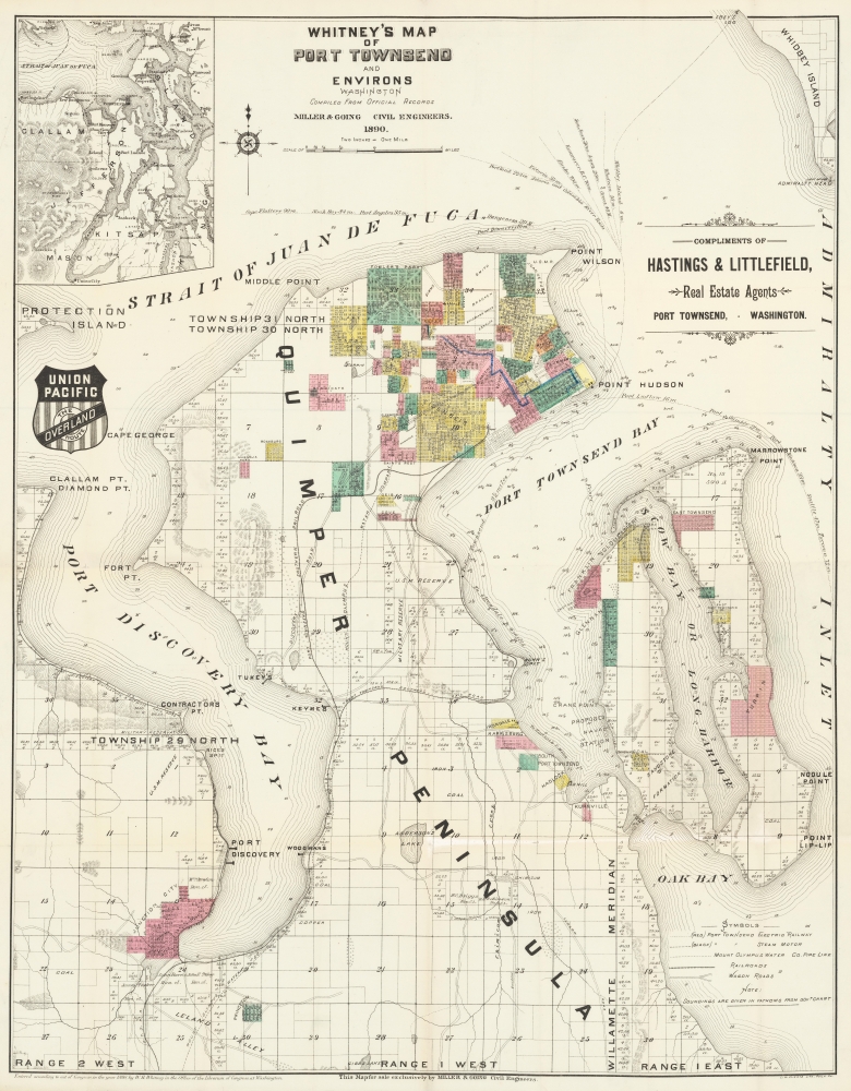
Whitney's Map of Port Townsend and Environs, Washington.
Whitney's 1890 map of Port Townsend stands out, as the Northern Pacific did not have service there, nor did it intend to. Although a prosperous port and lumber town, Port Townsend was on the wrong side of the Puget Sound, had comparatively small population, and a rail link would have been far too expensive. Port Townsend put together a grassroots effort to build its own connecting line to Tacoma, financing the Port Townsend Southern, although it never extended more than 27 miles. Also in 1890, and shown here, Port Townsend residents also formed the Port Townsend and Southern Railroad to Quilcene. The city was nonetheless, not connected to a Union Pacific until 1923.
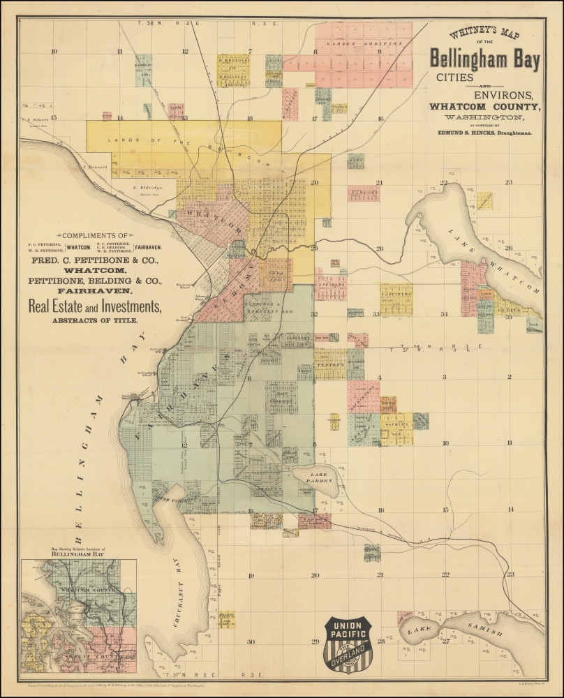
Whitney's Map of the Bellingham Bay Cities and Environs, Whatcom County, Washington.
Whitney's 1890 map of the Bellingham Bay cities illustrates multiple attempts to connect to a transcontinental railroad. Like Port Townsend, Bellingham Bay was not a destination for the Northern Pacific. Instead residents organized their own grassroots efforts to connect. The Bellingham Bay and British Columbia Railroad, shown here, was constructed to connect to the Canadian Pacific Line. Another connection also mapped here, the Fairhaven and Southern, in 1891 connected to the Great Northern Line, a competitor of the Union Pacific. Why the Union Pacific commissioned Whitney to make this map remains unclear.
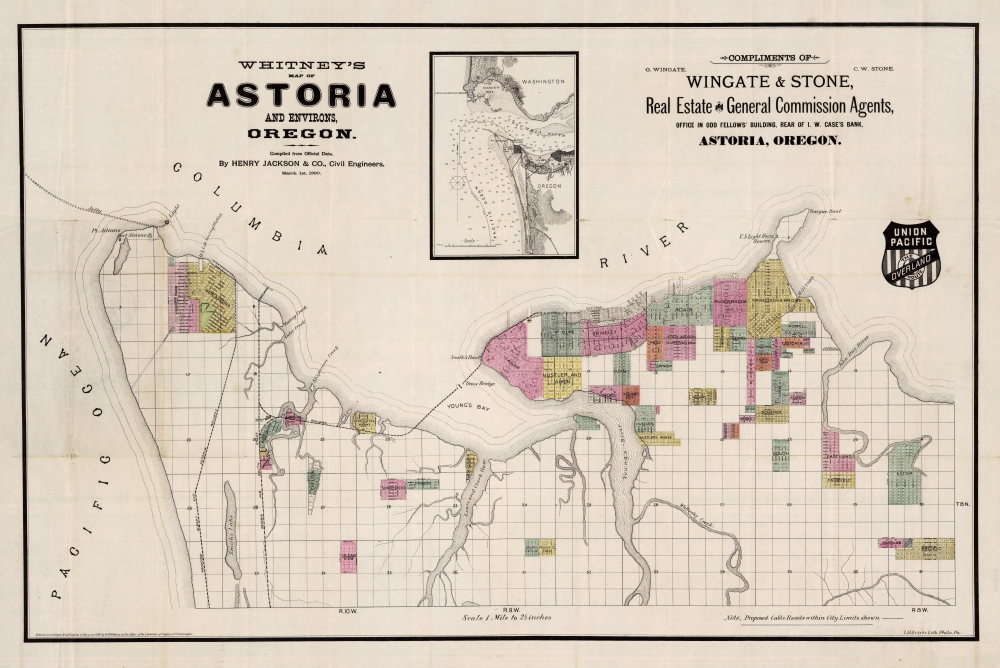
Whitney's Map of Astoria and Environs, Oregon.
Another Whitney oddity, this is his 1890 map of Astoria, Oregon. Astoria was the first American town in the Pacific Northwest - founded by John Jacob Astor as a fur trade depot on the Columbia River. In the 1880s, it was an important port, but had no railroad links. In 1890, the Astoria and South Coast Railway was constructed to link Astoria with Warrenton and Seaside. Connections to the Union Pacific were not completed until 1898. Another proposed line, the Albany and Astoria, was submitted to Congress but met with considerable opposition and never materialized.
Related Posts and Information
Maps on Geographicus by J. H. Whitney
Cartographer: Louis Humphrey Everts
Cartographer: Denver Lithographing
Cartographer: Frederick Gordon Plummer
Cartographer: William Henry Jackson
overall rating:
my rating:
log in to rate
Recent Posts
Hysterical Maps of the Lindgren Brothers: A Cartobibliography
Mapmaker in Focus: Edward Spofford, inventor of the Supervue
How to Frame Antique Maps
Gordon-Michael Scallion's Doomsday Maps
The Most Successful 16th Century Geographic Fraud
W. H. Whitney Maps of Railroad Cities
Categories
Cartographer Posts
Cartographic Themes
Map How-To
all
Archives
January, 2025
December, 2024
January, 2024
December, 2023
January, 2023
archive article list