Digital Image: 1777 William Herbert Nautical Map of Batavia (Jakarta), Indonesia
BantamBatavia-herbert-1777_d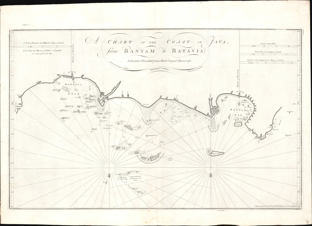


Title
A Chart of the Coast of Java from Bantam to Batavia.
1777 (dated) 20.25 x 33 in (51.435 x 83.82 cm) 1 : 220000
1777 (dated) 20.25 x 33 in (51.435 x 83.82 cm) 1 : 220000
Description
FOR THE ORIGINAL ANTIQUE MAP, WITH HISTORICAL ANALYSIS, CLICK HERE.
Digital Map Information
Geographicus maintains an archive of high-resolution rare map scans. We scan our maps at 300 DPI or higher, with newer images being 600 DPI, (either TIFF or JPEG, depending on when the scan was done) which is most cases in suitable for enlargement and printing.
Delivery
Once you purchase our digital scan service, you will receive a download link via email - usually within seconds. Digital orders are delivered as ZIP files, an industry standard file compression protocol that any computer should be able to unpack. Some of our files are very large, and can take some time to download. Most files are saved into your computer's 'Downloads' folder. All delivery is electronic. No physical product is shipped.
Credit and Scope of Use
You can use your digial image any way you want! Our digital images are unrestricted by copyright and can be used, modified, and published freely. The textual description that accompanies the original antique map is not included in the sale of digital images and remains protected by copyright. That said, we put significant care and effort into scanning and editing these maps, and we’d appreciate a credit when possible. Should you wish to credit us, please use the following credit line:
Courtesy of Geographicus Rare Antique Maps (https://www.geographicus.com).
How Large Can I Print?
In general, at 300 DPI, you should at least be able to double the size of the actual image, more so with our 600 DPI images. So, if the original was 10 x 12 inches, you can print at 20 x 24 inches, without quality loss. If your display requirements can accommodate some loss in image quality, you can make it even larger. That being said, no quality of scan will allow you to blow up at 10 x 12 inch map to wall size without significant quality loss. For more information, it is best consult a printer or reprographics specialist.
Refunds
If the high resolution image you ordered is unavailable, we will fully refund your purchase. Otherwise, digital images scans are a service, not a tangible product, and cannot be returned or refunded once the download link is used.
Cartographer S
William Herbert (November 29, 1718 – March 18, 1795) was a British map seller, book seller, publisher, and surveyor based in London in the second half of the 18th century. Herbert was born in London, the son of a dyer and hosier of Gravel Lane. He signed on to the East India company in 1738 as a purser's clerk, traveling in the process to the colonies in India. He returned to London in about 1745, having amassed a considerable collection of manuscript plans and charts of East India ports. Recognizing their commercial value, he set up business as a map and print seller on London Bridge in 1748. The premises of this business were sadly destroyed while Herbed watched the April 11, 1759 London Fire. He published a number of maps as well as the important New Directory for the East Indies. Much of his most important cartographic work seem to be associated with William Nichelson, who traveled to the East Indies in the 1750s and 60s mapping ports on behalf of the EOC. He retired in 1776 in reasonable comfort. His publications continued to be updated and re-published by his successors, among them Samuel Dunn and Henry Gregory. More by this mapmaker...
Henry Gregory (1744 - c. 1811) was an English chart and instrument maker active in London. Gregory was born in England. Gregory was apprenticed to John Fowler in 1732. He was in business for himself from c. 1750, operating 'The Azimuth Compass' in Leadenhall Street, London. He was a protégé of William Herbert (1718 – 1795) whose chart stock he took over in 1776. As a chartmaker, he produced the 1769 Directions for navigating from the Channel to the East Indies and the 1774 An Account of the Constant and Periodical Trade-Winds: or Monsoons, the Land and Sea Breezes. He collaborated with Samuel Dunn (1723 - 1794) on the 1775 Navigator's guide to the Oriental or Indian Seas. That same year, he took over the publication of Herbert's New Directory for the East Indies. Among the many instruments he produced, his azimuth compasses received praise from no lesser light than explorer James Cook (1728 - 1779) and were used in numerous late 18th century British voyages of exploration. Henry Gregory partnered with Gabriel Wright, operating as 'Gregory and Wright' from in 1782 - 1790, based at Navigation Warehouse, 148 Leadenhall Street, London (Gloria Clifton, G. Directory of British Scientific Instrument Makers, 1550 - 1851). Learn More...
Source
Herbert, W., New Directory for the East Indies, (London: Gregory) 1777.
References
OCLC 7457294.