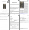
Digital Image: 1247 Huang Shang 'Dili Tu' Map of China - earliest Map of China!
DiliTu-huangshang-1247_d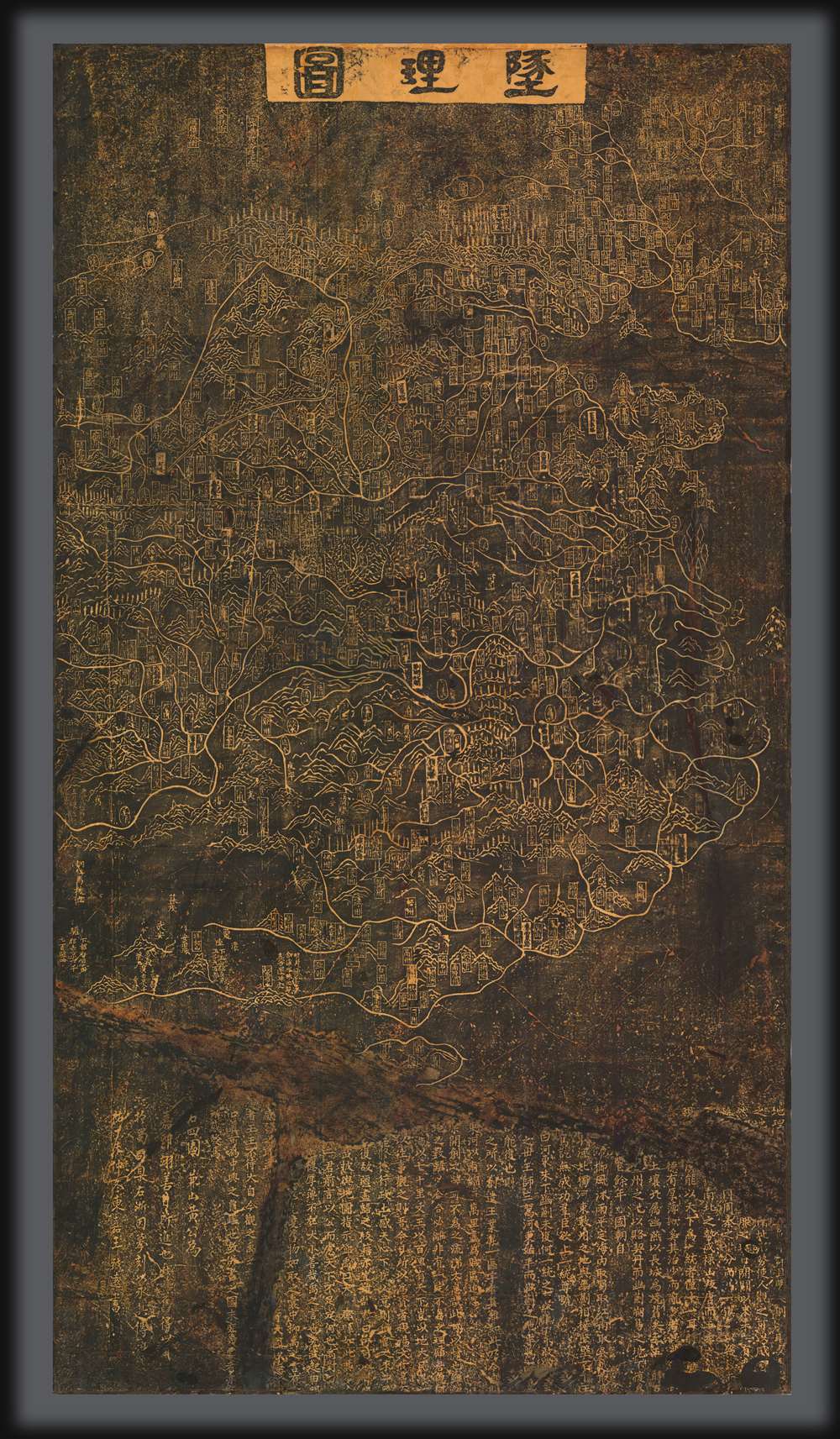


Title
Dili tu. / 墬理圖
1247 (undated) 72 x 39.5 in (182.88 x 100.33 cm)
1247 (undated) 72 x 39.5 in (182.88 x 100.33 cm)
Description
FOR THE ORIGINAL ANTIQUE MAP, WITH HISTORICAL ANALYSIS, CLICK HERE.
Digital Map Information
Geographicus maintains an archive of high-resolution rare map scans. We scan our maps at 300 DPI or higher, with newer images being 600 DPI, (either TIFF or JPEG, depending on when the scan was done) which is most cases in suitable for enlargement and printing.
Delivery
Once you purchase our digital scan service, you will receive a download link via email - usually within seconds. Digital orders are delivered as ZIP files, an industry standard file compression protocol that any computer should be able to unpack. Some of our files are very large, and can take some time to download. Most files are saved into your computer's 'Downloads' folder. All delivery is electronic. No physical product is shipped.
Credit and Scope of Use
You can use your digial image any way you want! Our digital images are unrestricted by copyright and can be used, modified, and published freely. The textual description that accompanies the original antique map is not included in the sale of digital images and remains protected by copyright. That said, we put significant care and effort into scanning and editing these maps, and we’d appreciate a credit when possible. Should you wish to credit us, please use the following credit line:
Courtesy of Geographicus Rare Antique Maps (https://www.geographicus.com).
How Large Can I Print?
In general, at 300 DPI, you should at least be able to double the size of the actual image, more so with our 600 DPI images. So, if the original was 10 x 12 inches, you can print at 20 x 24 inches, without quality loss. If your display requirements can accommodate some loss in image quality, you can make it even larger. That being said, no quality of scan will allow you to blow up at 10 x 12 inch map to wall size without significant quality loss. For more information, it is best consult a printer or reprographics specialist.
Refunds
If the high resolution image you ordered is unavailable, we will fully refund your purchase. Otherwise, digital images scans are a service, not a tangible product, and cannot be returned or refunded once the download link is used.
Cartographer
Huang Shang (黃裳; 1146 - 1195) was a Chinese official, tutor, polymath, and cartographer of the Southern Song Dynasty. He is known for at least three maps, the Dili Tu (墬理圖) terrestrial map, the Tianwen tu (天文圖) star chart, and a third relief map now lost, and it is believed that he made at least five others. Huang was born in Longqing Prefecture (隆慶府) now part of Zitong County in Sichuan Province. He passed the jinshi level of the imperial exams in the 5th year of the Xiaozong Emperor's reign (1167 CE) and became a county official in Bazhou (巴州) in Sichuan. He graduated from the Taixue Imperial Academy (in Hangzhou at this time) and held several official positions in the following decades, including as a tutor to 'Prince Jia' (that is, Zhao Kuo 趙擴, the future Ningzong Emperor), in 1190. He presented eight maps in total to the prince, including a map of China carved in wood - the Dili Tu. Huang intended for the Dili Tu to teach the value and importance of reuniting the empire which was split between the northern Chinese Jin Dynasty and the Southern Song sixty years earlier. Huang held high-level positions in the late Xiaozong era and during the brief reign of the Guangzong Emperor (r. 1189 - 1194), including Imperial Household Secretary (起居舍人), Head of the Imperial Secretariat (中書舍人), and Imperial Secretary (給事中). Being a close advisor of Zhao Kuo, he advanced even further when Zhao became the Ningzong Emperor, becoming Imperial Tutor (侍讀) and Minister of Rites (禮部尚書), arguably the most important position in the imperial bureaucracy. Aside from maps, Huang wrote several works that fit well within the Neo-Confucian ideology that had become dominant at the time, heavily citing classical texts and doctrines.
黄裳(1146 - 1195),南宋官员、学者、导师、博学之士与制图家。以至少三幅地图闻名,包括《墬理图》陆地地图、《天文图》星图,以及一幅已佚失的地形图,另推测他还制作过至少五幅其他地图。黄裳生于隆庆府(今四川梓潼县),孝宗五年(1167年)中进士,初任四川巴州县官。后卒业于太学(时在杭州),在数十年间历任多职,包括1190年任嘉王(即赵扩,后来的宁宗皇帝)之师。其间曾向太子献八幅地图,其中包括木刻版《墬理图》,旨在阐明统一帝国的重要性——六十年前帝国已被金朝与南宋分裂。黄裳在孝宗末及光宗(1189—1194年)朝任起居舍人、中书舍人、给事中等高位。赵扩即位后,因关系亲近而晋为侍读、礼部尚书,此为当时最重要的官职之一。除地图外,黄裳亦著有多部作品,契合当时占主导的新儒学思想,广引经典与义理。
More by this mapmaker...