Digital Image: 1906 Lawrence Panoramic Photograph of San Francisco, Earthquake and Fire Ruins
SFRuins-lawrence-1906_d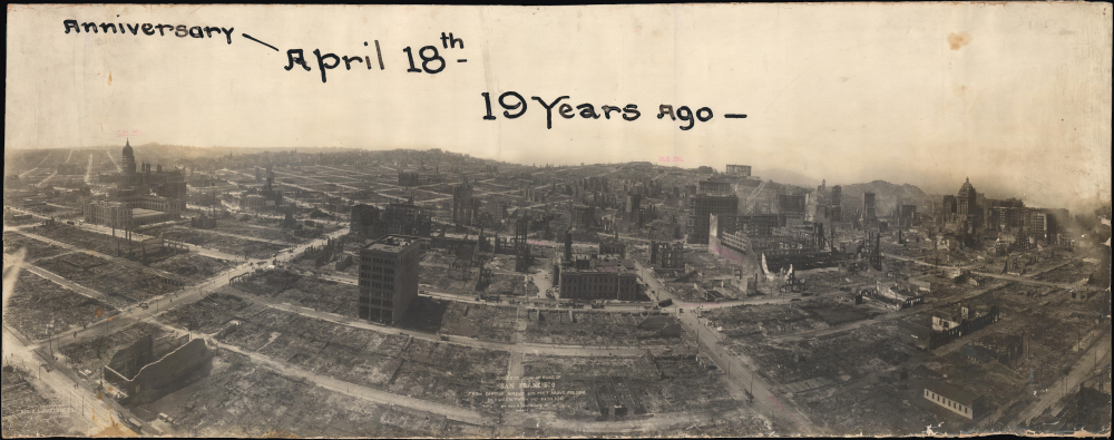


Title
Birds-Eye View of Ruins of San Francisco from Captive Airship 600 Feet above Folsom between Fifth and Sixth Sts.
1906 (undated) 17.75 x 45.25 in (45.085 x 114.935 cm)
1906 (undated) 17.75 x 45.25 in (45.085 x 114.935 cm)
Description
FOR THE ORIGINAL ANTIQUE MAP, WITH HISTORICAL ANALYSIS, CLICK HERE.
Digital Map Information
Geographicus maintains an archive of high-resolution rare map scans. We scan our maps at 300 DPI or higher, with newer images being 600 DPI, (either TIFF or JPEG, depending on when the scan was done) which is most cases in suitable for enlargement and printing.
Delivery
Once you purchase our digital scan service, you will receive a download link via email - usually within seconds. Digital orders are delivered as ZIP files, an industry standard file compression protocol that any computer should be able to unpack. Some of our files are very large, and can take some time to download. Most files are saved into your computer's 'Downloads' folder. All delivery is electronic. No physical product is shipped.
Credit and Scope of Use
You can use your digial image any way you want! Our digital images are unrestricted by copyright and can be used, modified, and published freely. The textual description that accompanies the original antique map is not included in the sale of digital images and remains protected by copyright. That said, we put significant care and effort into scanning and editing these maps, and we’d appreciate a credit when possible. Should you wish to credit us, please use the following credit line:
Courtesy of Geographicus Rare Antique Maps (https://www.geographicus.com).
How Large Can I Print?
In general, at 300 DPI, you should at least be able to double the size of the actual image, more so with our 600 DPI images. So, if the original was 10 x 12 inches, you can print at 20 x 24 inches, without quality loss. If your display requirements can accommodate some loss in image quality, you can make it even larger. That being said, no quality of scan will allow you to blow up at 10 x 12 inch map to wall size without significant quality loss. For more information, it is best consult a printer or reprographics specialist.
Refunds
If the high resolution image you ordered is unavailable, we will fully refund your purchase. Otherwise, digital images scans are a service, not a tangible product, and cannot be returned or refunded once the download link is used.
Cartographer
George Raymond Lawrence (February 24, 1868 – December 15, 1938) was an American photographer renowned for his innovative contributions to large-format and aerial photography. Born in Ottawa, Illinois, he moved to Chicago around 1890 and began working at a buggy company, where he showed an adeptness for tinkering and technical innovations. In 1891, he opened a photography studio (Geo. R. Lawrence Company), where he experimented with new techniques with the rapidly evolving technology, including perfecting flashlight photography, which would become standard for years afterwards. He adopted the slogan: 'The Hitherto Impossible in Photography is Our Specialty.' In 1900, Lawrence constructed the world's largest camera to capture a single image of the Chicago & Alton Railway's Alton Limited train. The camera weighed 1,400 pounds and utilized a glass plate measuring 8 feet by 4.5 feet. The resulting photograph earned the 'Grand Prize of the World' at the 1900 Exposition Universelle in Paris. Lawrence also pioneered aerial photography, initially using manned balloons to capture elevated views. After experiencing a near-fatal accident when a balloon malfunctioned, he transitioned to using unmanned kites to lift cameras. This technique led to his iconic 1906 series of photographs, 'San Francisco in Ruins,' taken shortly after the devastating earthquake from hundreds of feet above the city. In addition to photographs taken at ground level showing the destruction, these panoramic photographs were a financial and reputational boon for Lawrence. However, later efforts, particularly a fruitless 1909 expedition to photograph animals in British East Africa, did not see similar successes. Facing something of a professional and personal crisis around 1910 (Lawrence's first wife discovered an affair, and the two were divorced), he ventured into aviation design, securing numerous patents for aviation-related devices. However, his aircraft company failed in 1919. Lawrence passed away in 1938 at the age of 70. More by this mapmaker...
References
OCLC 439170505, 37843176.