Digital Image: 1711 Moll Map of Global Trade Winds
TradeWinds-moll-1711_d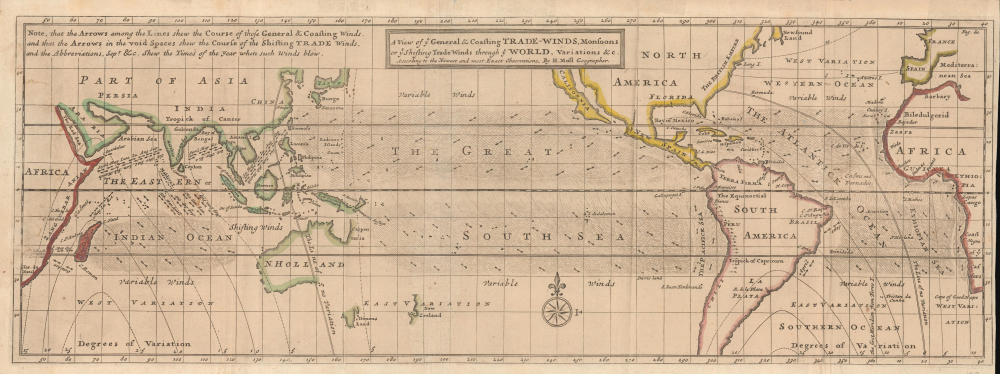

Title
A View of ye General and Coasting Trade-Winds, Monsoons or ye Shifting Trade Winds through ye World, Variations and c. According to the Newest and Most Exact Observations.
1711 (undated) 7 x 20 in (17.78 x 50.8 cm) 1 : 79000000
1711 (undated) 7 x 20 in (17.78 x 50.8 cm) 1 : 79000000
Description
FOR THE ORIGINAL ANTIQUE MAP, WITH HISTORICAL ANALYSIS, CLICK HERE.
Digital Map Information
Geographicus maintains an archive of high-resolution rare map scans. We scan our maps at 300 DPI or higher, with newer images being 600 DPI, (either TIFF or JPEG, depending on when the scan was done) which is most cases in suitable for enlargement and printing.
Delivery
Once you purchase our digital scan service, you will receive a download link via email - usually within seconds. Digital orders are delivered as ZIP files, an industry standard file compression protocol that any computer should be able to unpack. Some of our files are very large, and can take some time to download. Most files are saved into your computer's 'Downloads' folder. All delivery is electronic. No physical product is shipped.
Credit and Scope of Use
You can use your digial image any way you want! Our digital images are unrestricted by copyright and can be used, modified, and published freely. The textual description that accompanies the original antique map is not included in the sale of digital images and remains protected by copyright. That said, we put significant care and effort into scanning and editing these maps, and we’d appreciate a credit when possible. Should you wish to credit us, please use the following credit line:
Courtesy of Geographicus Rare Antique Maps (https://www.geographicus.com).
How Large Can I Print?
In general, at 300 DPI, you should at least be able to double the size of the actual image, more so with our 600 DPI images. So, if the original was 10 x 12 inches, you can print at 20 x 24 inches, without quality loss. If your display requirements can accommodate some loss in image quality, you can make it even larger. That being said, no quality of scan will allow you to blow up at 10 x 12 inch map to wall size without significant quality loss. For more information, it is best consult a printer or reprographics specialist.
Refunds
If the high resolution image you ordered is unavailable, we will fully refund your purchase. Otherwise, digital images scans are a service, not a tangible product, and cannot be returned or refunded once the download link is used.
Cartographer S
Herman Moll (1654 - 1732) was an important 18th century map publisher and engraver based in London and Holland. Moll's origins are disputed with some suggesting he was born in the Netherlands and others Germany - the Moll name was common in both countries during this period. Most likely Moll was a German from Bremen, as his will, friends, and contemporaries suggest. What is known for certain is that he moved to London in 1678, possibly fleeing the Scanian War, where he worked as an engraver for Moses Pitt and other London map publishers. Around the turn of the century, Moll set up his own shop where he produced a large corpus of work known for its high quality and decorative flair. As a new émigré to England, Moll made himself more English than the English, and through his cartography proved a fierce advocate for his adopted nation. Most of Moll's early maps were issued as loose sheets that would be bound to order, however, he did publish several important atlases late in his career. Moll is said to have made the bold claim that without a doubt "California is an Island" and that he "had in [his] office mariners who have sailed round it." While California may not be an island (yet), it is true that Moll had talent for attracting interesting friends and acquaintances. He frequented London's first stock exchange, Jonathan's Coffeehouse at Number 20 Exchange Alley, Cornhill. At the time Jonathan's was known as "a place of very considerable concourse for Merchants, sea faring Men and other traders" (Erleigh, The Viscount, The South Sea Bubble, Manchester: Peter Davies, Ltd., 1933, 21). Eventually this activity attracted the interest of stock brokers, who inspired by sailor's tales, sponsored the ill-fated South Sea Company, the world's first stock bubble. Moll's close circle, mostly from the Coffee House, included scientist Robert Hooke, the writers Daniel Defoe (Robinson Crusoe) and Jonathan Swift (Gulliver's Travels), the pirates William Dampier, William Hacke and Woodes Rogers, and the archeologist William Stukeley. Herman Moll's work was highly regarded for its decorative beauty and was pirated, most notably by the Irish publisher George Grierson, both in his lifetime and after his 1732 death at St. Clement Danes, London. More by this mapmaker...
Edmond (Edmund) Halley (November 8, 1656 - January 25, 1742) was an English astronomer, geophysicist, mathematician, meteorologist, and physicist. As Halley was such an accomplished individual, this biography will only be concerned with his contributions to cartography, of which there were many. Today, Halley is credited with the development of the earliest meteorological chart and the first printed isoline map. He also produced a map of the shadow of a solar eclipse that passed through London and a tidal chart. These maps are considered to be major contributions in thematic cartography. During the year 1686, Halley published four papers in the Philosophical Transactions. One of these, entitled 'An Historical Account of the Trade Winds, and Monsoons, observable in the Seas between and Near the Tropicks; with an attempt to assign the Phisical cause of the said Winds' was illustrated what has become known as the first meteorological chart. Although untitled, this map has come to be known as 'Halley's Chart of the Trade Winds'. Unaccompanied by a legend or a key, the only way to understand this map is to read Halley's article. The map lacks a scale, and the size of the grid varies, making Halley's first important map of the Earth difficult to interpret. In 1698, Halley was granted a temporary commission as a Captain in the Royal Navy and given command of the Paramour, a newly-built ship with the express purpose of test his magnetic theory in the southern hemisphere. Halley's voyage has become known as 'the first sea journey undertaken for a purely scientific object'. After being forced to return to Britain to deal with a mutinous crew, Halley set off anew in 1699 to test his theories. Following his return from more than a year aboard the Paramour, Halley published one of the most important maps in the history of cartography. Titled, 'A New and Correct Chart showing the Variations of the Compass in the Western and Southern Oceans' and based on over 150 observations on magnetic declination, this map is said to be the first printed map showing isotopes (lines of equal magnetic attraction). Per Norman Thrower
Halley's Atlantic chart is not only the first printed map of isogones, which were known as Halleyan lines for about a century, but it appears to be the earliest published isarithmic map of any kind. In quantitative cartography, isarithms (isolines) are lines, in series, connecting points of equal intensity of phenomena which have transitional degrees of intensity.Halley's Atlantic chart was not published to accompany an article, it was actually published as a sheet map and measured 22.5 x 19 inches. Halley's next contribution to the history of cartography was a much larger world chart along the same lines as his Atlantic chart. This chart measured 20 x 57 inches on a Mercator projection. Most of the innovations associated with the world chart are similar to those of the Atlantic chart, just on a larger scale. Halley also undertook a survey off the English Channel, entitled ' A New and Correct Chart of the Channel between England and France with considerable Improvements not extant in any Draughts hitherto Publish'd shewing the sands, shoals, depths of Water and Anchorage, with yet flowing of the Tydes, and the setting of the Current; as observed by the Learned Dr. Halley.' Spanning two sheets, each measuring 25 x 19 inches, this chart was likely published in 1702. The chart bears numerous notations and conventions common by Halley's time, but the feature that sets it apart from 'all previous charts' is the inclusion of the tides
Halley's final cartographic contribution deals with a map entitled 'A Description of the Passage of the Shadow of the Moon over England in the Total Eclipse of the Sun on the 22nd Day of April 1715 in the Morning'. The general map, in itself, is unremarkable, but the map's theme is both interesting and original. The map traces the path and shadow of the eclipse and indicates the time it took the eclipse to cross England. Learn More...
Source
Moll, H., Atlas geographus, or, a compleat system of geography, ancient and modern, Vol. 1, (London: J. Nutt) 1711.
References
OCLC 28357009, 633086983, 1012917135.