This item has been sold, but you can get on the Waitlist to be notified if another example becomes available, or purchase a digital scan.
1730 Covens and Mortier Map of South America
SouthAmerica-covensmortier-1730$875.00

Title
Tabula Geographica Peruae, Braziliae & Amazonum Regionis. / Carte de la Terre Ferme du Perou, du Bresil, et du Pays des Amazones. / Tabula Geographica Paragiae, Chilis, Freti a Magellanici & c. / Carte du Paraguay, Du Chili, du Detroit de Magellan & c.
c. 1730 (undated) 41 x 23 in (104.14 x 58.42 cm)
c. 1730 (undated) 41 x 23 in (104.14 x 58.42 cm)
Description
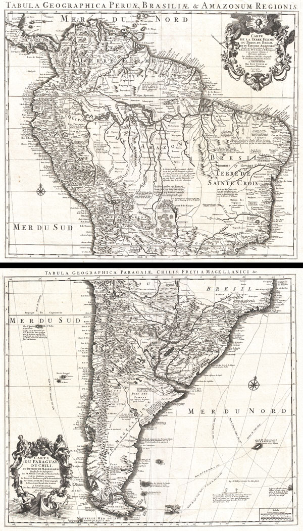
An extraordinary example of a c. 1730 two map set depicting South America. This is Covens and Mortier's c. 1730 reissue of Guillaume de L'Isle's magnificent c. 1708 map of this region. The northern sheet covers from Costa Rica and Barbados south roughly to the Tropic of Capricorn or more precisely 50 degrees south latitude. Southern sheet covers roughly from 18 degrees south latitude south to Tierra del Fuego. Both maps are notable for their extraordinary condition with a dark strong impression on clean white paper. Early 18th century maps rarely appear in this superb condition.
The northern sheet of this set, like most early maps of the area, contrasts a detailed mapping of the coast with a speculative discussion of the interior, particularly the Amazon Basin. Offers a fairly accurate mapping of both the east and west coasts with exceptional detail in the populated Andean regions of Columbia, Ecuador (Labeled Quito), and Peru. Notes Cuzco, Lima, Quito, Valladolid, Arequipa, Trujillo and other important trading centers of the region. In Portuguese controlled Brazil, Rio de Janeiro, San Salvador and San Sebastian are noted. Lake Maracaibo, in modern day Venezuela, is slightly malformed and elongated.
The interior is where this map gets interesting. De L'lsle was a cautious and scientific cartographer, who based his maps on the first hand reports from sailors, merchants and missionaries that, at the time, were flowing into Paris at an unprecedented rate. Consequently many of his maps offer significant cartographic advances over their predecessors. This map is no exception and De L'Isle credits the mappings and explorations of Alonzo de Herrera, Johannes de Laet, P.P. D Acuna and M. Rodriguez. Nonetheless, De L'Isle's mapping of South America's interior is full of inaccuracy, curiosities, and ample fodder for the gold hunting European. Our survey of this map begins with De L'Isle's impressively accurate mapping of the Amazon and Orinoco River systems - though he does erroneously connect the two, an understandable error common to maps of the period. Roughly where the Grand Sabana is today, in modern day Venezuela, De L'Isle speculates the location of Lake Parima and the city of El Dorado (curiously this is actually gold rich region though difficult to access and mine). Further South he notates numerous gold rich indigenous groups including Los Plateros and Xarayes.
The Xarayes, a corruption of 'Xaraiés' meaning 'Masters of the River,' were an indigenous people occupying what are today parts of Brazil's Matte Grosso and the Pantanal. When Spanish and Portuguese explorers first navigated up the Paraguay River, as always in search of El Dorado, they encountered the vast Pantanal flood plain at the height of its annual inundation. Understandably misinterpreting the flood plain as a gigantic inland sea, they named it after the local inhabitants, the Xaraies. The Laguna de los Xarayes almost immediately began to appear on early maps of the region and, at the same time, almost immediately took on a legendary aspect. Later missionaries and chroniclers, particularly Díaz de Guzmán, imagined an island in this lake and curiously identified it as an 'Island of Paradise,'
The southern sheet of this two map set, like its northern counterpart, exhibits a detailed coastline reflecting a fairly accurate early mapping of the region. The relatively easy navigation along the Rio de La Plata and its tributaries, as well as the relative narrowness of the continent and accessibility of the Pampas, offered ample opportunity for easy mapping. Here De L'Isle attributes his map to the explorations and descriptions of this region provided by Afonso de Ovalle and Nicholas Techo. Like the northern sheet, this map also shows the mythical Laguna de Zarayes, though here it is spelled Xaraies and does not include the 'Island of Paradise.'
Further south, De L'Isle suggests that the Santa Cruz River, or the 'Rio St. Julien' as it is labeled here, connects (or nearly so) with the Rio de la Campana coming from the Pacific, thus connecting the Atlantic to the South Seas via an easy overland river route. The idea of a river route transversing Patagonia caught the European imagination in the early 18th Century. The writer Daniel Defoe proposes a similar route further north in his book A New Voyage and such concepts appeared in several maps of the period including Herman Moll's important map of the South Sea Company. Of course, the Andes were in fact an indomitable barrier and short of the treacherous Strait of Magellan itself, no such water route existed.
Some of the most interesting elements of this map appear far from the mainland in the surrounding seas. The routes of several important explorers are indicated including Pedro Sarmiento in 1589, La Roche in 1675, Halley in 1700, Amerigo Vespucci in 1502 and Captain Charp in 1681. The Falklands are depicted in an embryonic form as identified by Captain La Roche in 1575. Also notes Francis Drake's discovery of Cape Horn. In the lower right hand quadrant there are two interesting images of stylized penguins accompanied with a description in French, probably attributable to the explorer Lozier Bouvet, so charming that I felt obligated to translate and include here,
Altogether this is a spectacular map set in extraordinary condition. Stands up to hours of perusal and presents dramatically.
The northern sheet of this set, like most early maps of the area, contrasts a detailed mapping of the coast with a speculative discussion of the interior, particularly the Amazon Basin. Offers a fairly accurate mapping of both the east and west coasts with exceptional detail in the populated Andean regions of Columbia, Ecuador (Labeled Quito), and Peru. Notes Cuzco, Lima, Quito, Valladolid, Arequipa, Trujillo and other important trading centers of the region. In Portuguese controlled Brazil, Rio de Janeiro, San Salvador and San Sebastian are noted. Lake Maracaibo, in modern day Venezuela, is slightly malformed and elongated.
The interior is where this map gets interesting. De L'lsle was a cautious and scientific cartographer, who based his maps on the first hand reports from sailors, merchants and missionaries that, at the time, were flowing into Paris at an unprecedented rate. Consequently many of his maps offer significant cartographic advances over their predecessors. This map is no exception and De L'Isle credits the mappings and explorations of Alonzo de Herrera, Johannes de Laet, P.P. D Acuna and M. Rodriguez. Nonetheless, De L'Isle's mapping of South America's interior is full of inaccuracy, curiosities, and ample fodder for the gold hunting European. Our survey of this map begins with De L'Isle's impressively accurate mapping of the Amazon and Orinoco River systems - though he does erroneously connect the two, an understandable error common to maps of the period. Roughly where the Grand Sabana is today, in modern day Venezuela, De L'Isle speculates the location of Lake Parima and the city of El Dorado (curiously this is actually gold rich region though difficult to access and mine). Further South he notates numerous gold rich indigenous groups including Los Plateros and Xarayes.
The Xarayes, a corruption of 'Xaraiés' meaning 'Masters of the River,' were an indigenous people occupying what are today parts of Brazil's Matte Grosso and the Pantanal. When Spanish and Portuguese explorers first navigated up the Paraguay River, as always in search of El Dorado, they encountered the vast Pantanal flood plain at the height of its annual inundation. Understandably misinterpreting the flood plain as a gigantic inland sea, they named it after the local inhabitants, the Xaraies. The Laguna de los Xarayes almost immediately began to appear on early maps of the region and, at the same time, almost immediately took on a legendary aspect. Later missionaries and chroniclers, particularly Díaz de Guzmán, imagined an island in this lake and curiously identified it as an 'Island of Paradise,'
...an island [of the Paraguay River] more than ten leagues [56 km] long, two or three [11-16 km] wide. A very mild land rich in a thousand types of wild fruit, among them grapes, pears and olives: the Indians created plantations throughout, and throughout the year sow and reap with no difference in winter or summer, ... the Indians of that island are of good will and are friends to the Spaniards; Orejón they call them, and they have their ears pierced with wheels of wood ... which occupy the entire hole. They live in round houses, not as a village, but each apart though keep up with each other in much peace and friendship. They called of old this island Land of Paradise for its abundance and wonderful qualities.To the north of the 'Island of Paradise' appeared the 'Puerto de los Reyes' which was considered to be a gateway to the Amazon and the Kingdom of El Dorado. De L'Isle, to his credit, shows the 'Laguna' and it's island in a much reduced form compared to earlier cartographers. He also correctly does not connect the Paraguay River to the Amazon system.
The southern sheet of this two map set, like its northern counterpart, exhibits a detailed coastline reflecting a fairly accurate early mapping of the region. The relatively easy navigation along the Rio de La Plata and its tributaries, as well as the relative narrowness of the continent and accessibility of the Pampas, offered ample opportunity for easy mapping. Here De L'Isle attributes his map to the explorations and descriptions of this region provided by Afonso de Ovalle and Nicholas Techo. Like the northern sheet, this map also shows the mythical Laguna de Zarayes, though here it is spelled Xaraies and does not include the 'Island of Paradise.'
Further south, De L'Isle suggests that the Santa Cruz River, or the 'Rio St. Julien' as it is labeled here, connects (or nearly so) with the Rio de la Campana coming from the Pacific, thus connecting the Atlantic to the South Seas via an easy overland river route. The idea of a river route transversing Patagonia caught the European imagination in the early 18th Century. The writer Daniel Defoe proposes a similar route further north in his book A New Voyage and such concepts appeared in several maps of the period including Herman Moll's important map of the South Sea Company. Of course, the Andes were in fact an indomitable barrier and short of the treacherous Strait of Magellan itself, no such water route existed.
Some of the most interesting elements of this map appear far from the mainland in the surrounding seas. The routes of several important explorers are indicated including Pedro Sarmiento in 1589, La Roche in 1675, Halley in 1700, Amerigo Vespucci in 1502 and Captain Charp in 1681. The Falklands are depicted in an embryonic form as identified by Captain La Roche in 1575. Also notes Francis Drake's discovery of Cape Horn. In the lower right hand quadrant there are two interesting images of stylized penguins accompanied with a description in French, probably attributable to the explorer Lozier Bouvet, so charming that I felt obligated to translate and include here,
In this Glacial Sea there are many animals that are half bird and half fish; on the surface they pass like a swan coming out of the water only to take the air, the rest is always under water.Also in the lower right quadrant Amerigo Vespucci's ship appears as he crosses into the Western Hemisphere. Slightly to the northwest of this little ship another island appears, supposedly discovered by La Roche in 1675, and is mostly likely a mis-mapping of South Georgia Island.
Altogether this is a spectacular map set in extraordinary condition. Stands up to hours of perusal and presents dramatically.
CartographerS
Covens and Mortier (1721 - c. 1862) was an Amsterdam publishing firm, the successor to the extensive publishing empire built by Pierre Mortier (1661 - 1711). Covens and Mortier maps are often criticized as derivative - but this is not fully the case. Pierre Mortier lived in Paris from 1681 to 1685. There he established close relationships the the greatest French cartographers of the era, including De L'Isle and D'Anville. His business model was based upon leveraging Dutch printing technology and sophistication to co-publish state of the art French cartography. Upon Mortier's death in 1711 his firm was taken over by his son, Cornelius Mortier (1699 - 1783). Cornelius married the sister of Johannes Covens (1697 - 1774) in 1721 and, partnering with his brother in law, established the Covens and Mortier firm. Under the Covens and Mortier imprint, Cornelius and Johannes continued in Pierre's model of publishing the most up-to-date French works with permission. They quickly became one of the largest and most prolific Dutch publishing concerns of the 18th century. The firm and its successors published thousands of maps over a 120 year period from 1721 to the mid-1800s. During their long lifespan the Covens and Mortier firm published as Covens and Mortier (1721 - 1778), J. Covens and Son (1778 - 94) and Mortier, Covens and Son (1794 - c. 1862). More by this mapmaker...
The De L'Isle family (fl. c. 1700 - c. 1760) (also written Delisle) were, in composite, a mapmaking tour de force who redefined early 18th century European cartography. Claude De L'Isle (1644 -1720), the family patriarch, was Paris based a historian and geographer under Nicholas Sanson. De L'Isle and his sons were proponents of the school of "positive geography" and were definitive figures, defining the heights of the Golden Age of French Cartography. Of his twelve sons, four, Guillaume (1675 - 1726), Simon Claude (1675 - 1726), Joseph Nicholas (1688 - 1768) and Louis (1720 - 1745), made a significant contributions to cartography. Without a doubt Guillaume was the most remarkable member of the family. It is said that Guillaume's skill as a cartographer was so prodigious that he drew his first map at just nine years of age. He was tutored by J. D. Cassini in astronomy, science, mathematics and cartography. By applying these diverse disciplines to the vast stores of information provided by 18th century navigators, Guillaume created the technique that came to be known as "scientific cartography", essentially an extension of Sanson's "positive geography". This revolutionary approach transformed the field of cartography and created a more accurate picture of the world. Among Guillaume's many firsts are the first naming of Texas, the first correct map of the Mississippi, the final rejection of the insular California fallacy, and the first identification of the correct longitudes of America. Stylistically De L'Isle also initiated important changes to the medium, eschewing the flamboyant Dutch style of the previous century in favor of a highly detailed yet still decorative approach that yielded map both beautiful and informative. Guillaume was elected to the French Academie Royale des Sciences at 27. Later, in 1718, he was also appointed "Premier Geographe du Roi", an office created especially for him. De L'Isle personally financed the publication of most of his maps, hoping to make heavy royalties on their sales. Unfortunately he met an untimely death in 1728, leaving considerable debt and an impoverished child and widow. De L'Isle's publishing firm was taken over by his assistant, Phillipe Buache who became, posthumously, his son in law. The other De L'Isle brothers, Joseph Nicholas and Louis De L'Isle, were employed in the Service of Peter the Great of Russia as astronomers and surveyors. They are responsible for cataloguing and compiling the data obtained from Russian expeditions in the Pacific and along the northwest coast of America, including the seminal explorations of Vitus Bering and Aleksei Chirikov. The De L'Isles, like their rivals the Vaugondys , must be considered speculative geographers. Speculative geography was a genre of mapmaking that evolved in Europe, particularly Paris, in the middle to late 18th century. Cartographers in this genre would fill in unknown areas on their maps with speculations based upon their vast knowledge of cartography, personal geographical theories, and often dubious primary source material gathered by explorers and navigators. This approach, which attempted to use the known to validate the unknown, naturally engendered many rivalries. The era of speculatively cartography effectively ended with the late 18th century explorations of Captain Cook, Jean Francois de Galaup de La Perouse, and George Vancouver. Learn More...
Source
Covens, J. & Mortier, C., Atlas nouveau, contenant toutes les parties su Monde, ou sont exactement remarquees les empires, monarchies, royaumes, etats, republiques, &c. Par Guillaume de l'Isle, c. 1830 editon.
Condition
Incredible. A nearly flawless example of these two rare maps. We have rarely seen any 18th century maps in such phenomenal condition. Wide clean margins. White clean paper. Dark heavy impression. Original centerfold - as issued. If you plan to add an example of this map to your collection, then this is the one you want.
References
Rumsey 4638.102, 4638.103. Tooley, R. V., The Mapping of America, #74, #81. Tooley, R. V., French mapping of the Americas, #72. National Library of Australia, MAP RM 2591.