Digital Image: 1867 Holmes Map of the Upper West Side and Manhattan Valley, New York City
1-StrikersBayRogers-holmes-1867_d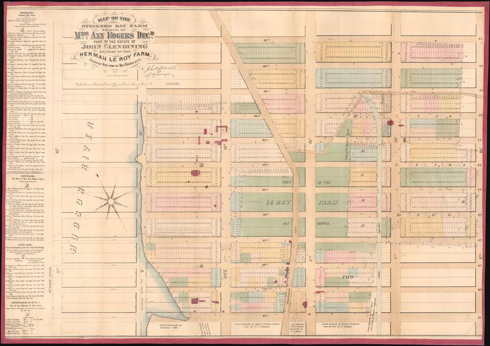

Title
Map of the Strikers Bay Farm Estate of Mrs. Ann Rogers Decd. Part of the estate of John Glendining and part of the Herman Le Roy Farm.
1867 (undated) 24 x 34 in (60.96 x 86.36 cm) 1 : 1866
1867 (undated) 24 x 34 in (60.96 x 86.36 cm) 1 : 1866
Description
FOR THE ORIGINAL ANTIQUE MAP, WITH HISTORICAL ANALYSIS, CLICK HERE.
Digital Map Information
Geographicus maintains an archive of high-resolution rare map scans. We scan our maps at 300 DPI or higher, with newer images being 600 DPI, (either TIFF or JPEG, depending on when the scan was done) which is most cases in suitable for enlargement and printing.
Delivery
Once you purchase our digital scan service, you will receive a download link via email - usually within seconds. Digital orders are delivered as ZIP files, an industry standard file compression protocol that any computer should be able to unpack. Some of our files are very large, and can take some time to download. Most files are saved into your computer's 'Downloads' folder. All delivery is electronic. No physical product is shipped.
Credit and Scope of Use
You can use your digial image any way you want! Our digital images are unrestricted by copyright and can be used, modified, and published freely. The textual description that accompanies the original antique map is not included in the sale of digital images and remains protected by copyright. That said, we put significant care and effort into scanning and editing these maps, and we’d appreciate a credit when possible. Should you wish to credit us, please use the following credit line:
Courtesy of Geographicus Rare Antique Maps (https://www.geographicus.com).
How Large Can I Print?
In general, at 300 DPI, you should at least be able to double the size of the actual image, more so with our 600 DPI images. So, if the original was 10 x 12 inches, you can print at 20 x 24 inches, without quality loss. If your display requirements can accommodate some loss in image quality, you can make it even larger. That being said, no quality of scan will allow you to blow up at 10 x 12 inch map to wall size without significant quality loss. For more information, it is best consult a printer or reprographics specialist.
Refunds
If the high resolution image you ordered is unavailable, we will fully refund your purchase. Otherwise, digital images scans are a service, not a tangible product, and cannot be returned or refunded once the download link is used.
Cartographer S
John Bute Holmes (March 31, 1822 - May 21, 1887) was an Irish civil engineer, city surveyor, and mapmaker based in New York City in the middle to latter 19th century. Holmes was described as a 'short, stout man, with curly gray hair, a smooth face, and a short, thick neck.' Holmes' father-in-law supplied funds for him to immigrate to America in 1840 and shortly thereafter, in 1844, he established himself in New York City. He briefly returned to Europe before once again settling in New York City in 1848. Apparently, according to several New York Times articles dating to the 1870s, Holmes was a man of dubious personal and moral character. He was involved in several legal disputes most of which were associated with his outrageous - even by modern standards - womanizing. In 1857 he was convicted of forgery of a marriage document and sentenced to 15 years of hard labor at Sing Sing, of which he served 5 before wealthy associates interceded on his behalf for an early release. Holmes seems to have been married to several different women at the same time and to have had an unfortunate attraction to exceptionally young women - one of whom, 16 year old May Chamberlayne claimed to be his wife and sued him for 50,000 USD. On another occasion he was found guilty of killing Brooklyn policeman David Gourly with whose wife he 'had been intimate.' Another woman, Miss Abrams, who he hired as a housekeeper, was repeatedly attacked by Holmes and ultimately driven to madness and was consigned to Bellevue Hospital, where she died. Although he attempted to flee the country rather than face conviction for 4th degree manslaughter, he was ultimately arrested and served one year in prison. During the American Civil War he ran for Alderman of the First Ward, in New York. Despite his legal issues, Holmes was a man of considerable means, with a personal fortune estimated between 100,000 and 500,000 USD - a significant sum in the late 19th century. Much of his wealth is associated with a series of important cadastral maps produced between 1867 and 1875 while he was employed as a surveyor and civil engineer under the corrupt Tweed regime. When Holmes died of an 'apoplectic fit' there was considerable wrangling over his estate among his 7 heirs and 11 children. The cream of his estate where his maps, some of which were valued at more than 30,000 USD in 1887. Holmes lived on a large farm-estate in Fanwood New Jersey. More by this mapmaker...
Gustav Braeunlich (May 17, 1837 - January 15, 1923) was a German-Russian artist, lithographer, and engraver active in New York during the middle to late 19th century. Braeunlich was born in St. Petersburg, Russia and was of German-Saxon-Russian descent. His father was a Bishop in the Russian Orthodox Church. As a young man he served in the Russian army and saw action in the Crimean War. Census records suggest Braeunlich immigrated to the United States in 1860, settling in Brooklyn and studying art at Cooper Union, where he won several awards. It is not clear when he partnered with his younger cousin, Herman Braeunlich, to establish the engraving and lithographing firm G. Braeunlich and Co., but it was active from at least the 1862. The firm had multiple offices. The first may have been at 85 White Street, Brooklyn. In 1877 he was based at 58 Maiden Lane, Manhattan, where he shared the premises with cousin Herman Braeunlich (November 11, 1843 - August 3, 1916) and relative William Brauenlich. The firm relocated to 39 West Broadway in 1880. During his most active period Braeunlich engraved maps for John B Holmes, Tobacco Revenue stamps for the U.S. Treasury Department, and presidential campaign materials for Samuel Tilden. Braeunlich and his family, including Herman, lived in the same residence at 250 East 73rd at 3rd Ave, Brooklyn. Their name alternatively appears as 'Braunlich' and 'Breunlich'. After Gustav retired Herman maintained the business until at least 1910 from 86th Fulton Street, Manhattan. Gustav was the nephew of an important Brooklyn physician of the same name. Learn More...
References
OCLC 50558352.