Digital Image: 1904 Welcke Lithograph View of New York's Murray Hill Neighborhood in 1879
5thAveNewYork-welcke-1904_d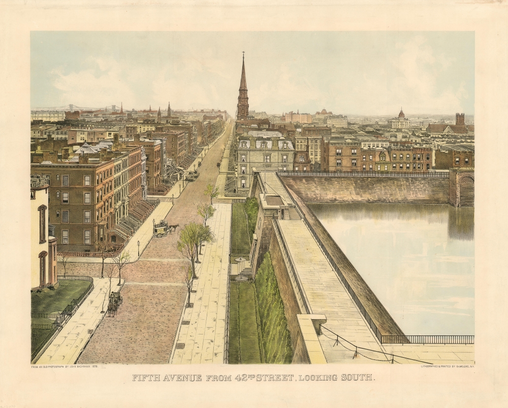

Title
Fifth Avenue from 42nd Street, Looking South.
1904 (dated) 17.75 x 22 in (45.085 x 55.88 cm)
1904 (dated) 17.75 x 22 in (45.085 x 55.88 cm)
Description
FOR THE ORIGINAL ANTIQUE MAP, WITH HISTORICAL ANALYSIS, CLICK HERE.
Digital Map Information
Geographicus maintains an archive of high-resolution rare map scans. We scan our maps at 300 DPI or higher, with newer images being 600 DPI, (either TIFF or JPEG, depending on when the scan was done) which is most cases in suitable for enlargement and printing.
Delivery
Once you purchase our digital scan service, you will receive a download link via email - usually within seconds. Digital orders are delivered as ZIP files, an industry standard file compression protocol that any computer should be able to unpack. Some of our files are very large, and can take some time to download. Most files are saved into your computer's 'Downloads' folder. All delivery is electronic. No physical product is shipped.
Credit and Scope of Use
You can use your digial image any way you want! Our digital images are unrestricted by copyright and can be used, modified, and published freely. The textual description that accompanies the original antique map is not included in the sale of digital images and remains protected by copyright. That said, we put significant care and effort into scanning and editing these maps, and we’d appreciate a credit when possible. Should you wish to credit us, please use the following credit line:
Courtesy of Geographicus Rare Antique Maps (https://www.geographicus.com).
How Large Can I Print?
In general, at 300 DPI, you should at least be able to double the size of the actual image, more so with our 600 DPI images. So, if the original was 10 x 12 inches, you can print at 20 x 24 inches, without quality loss. If your display requirements can accommodate some loss in image quality, you can make it even larger. That being said, no quality of scan will allow you to blow up at 10 x 12 inch map to wall size without significant quality loss. For more information, it is best consult a printer or reprographics specialist.
Refunds
If the high resolution image you ordered is unavailable, we will fully refund your purchase. Otherwise, digital images scans are a service, not a tangible product, and cannot be returned or refunded once the download link is used.
Cartographer S
Robert A. Welcke (November 24, 1848 - January 27, 1936) was a photolithographer active in New York in the latter part of the 19th century and early 20th century. Welcke was born in Wronke, today in Poland, but then part of Prussia. He emigrated to New York City in 1869. After settling, Welcke went into the lithography business with his brother, Edward Welcke, who arrived a decade earlier. After a split between the brothers during the economic depression of the late 1870s, Robert Welcke continued in business on his own. Welcke's firm, Robert A. Welcke Offset Company, was based at 176 William Street. His corpus ranges from real estate maps of New York and Connecticut to illustrations on Flemish Renaissance interiors to government maps and brochures to decorative sheet music covers. Following Welcke's death, the firm was taken over by his daughter, Olga Welcke, who, alongside William Jugens, managed it until the outbreak of World War II (1939 - 1945). More by this mapmaker...
Max Williams (September 9, 1865 - December 5, 1927) was a German-American publisher and collector, active in New York City at the turn of the century. While he published the work of contemporaneous artists such as Robert Welcke, he is generally best known for his republishing of earlier works, in particular from Currier and Ives' original lithographic stones (Williams purchased the contents of Currier and Ives' shop upon its closing.) Williams was also apparently a collector of marine art himself, keeping a museum of nautical prints and exhibiting them to a public nostalgic for the age of sail. Learn More...
John Bachmann (1816 - May 22, 1899) was a Swiss-American landscape artist and viewmaker active in New York from the mid to late 19th century. Bachmann was born in Switzerland and apprenticed as a lithographer both in Switzerland and Paris until 1847. Like many Swiss and German printmakers, Bachmann was a Forty-Eighter, one of thousands who fled to the United States in the aftermath of the failed 'Springtime of the Peoples Revolutions of 1848'. He settled in Jersey City or Hoboken. His first publication, a spectacular view of New York City looking south from Union Square, appeared 1849. Although not the most prolific viewmaker, Bachmann is considered among the finest. He issued more than 50 views, two-thirds of which were of New York City. Bachman had a passion for New York and it's many civic advances and, unlike other viewmakers, some of his most interesting work of his work focused on these, including views of Greenwood Cemetery, Central Park, and Hoboken's Elysian Fields. He also has the distinction to be the first to use the term 'Bird's-eye' to describe his aerial-perspective views. During the American Civil War (1861 - 1865) he issued a series of innovative 'Seat of War' views illustrating the progress of the war in various theaters. These war views were revolutionary in their advanced use of perspective and orientation, to illustrate terrain and topography. His last known perspective view illustrated Havana. Bachmann's son, John Bachmann Jr. (1853 - 1927) (aka. Bachman) was also a lithographer. Learn More...
References
OCLC 861292700.