Digital Image: 1650 Pierre Mariette Map of Africa
Africa-mariette-1650_d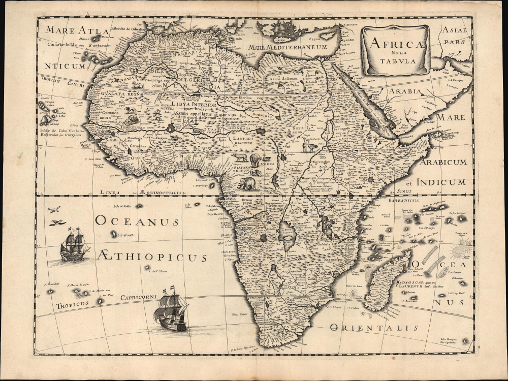

Title
Africae nova Tabula.
1650 (undated) 14 x 18.5 in (35.56 x 46.99 cm) 1 : 20000000
1650 (undated) 14 x 18.5 in (35.56 x 46.99 cm) 1 : 20000000
Description
FOR THE ORIGINAL ANTIQUE MAP, WITH HISTORICAL ANALYSIS, CLICK HERE.
Digital Map Information
Geographicus maintains an archive of high-resolution rare map scans. We scan our maps at 300 DPI or higher, with newer images being 600 DPI, (either TIFF or JPEG, depending on when the scan was done) which is most cases in suitable for enlargement and printing.
Delivery
Once you purchase our digital scan service, you will receive a download link via email - usually within seconds. Digital orders are delivered as ZIP files, an industry standard file compression protocol that any computer should be able to unpack. Some of our files are very large, and can take some time to download. Most files are saved into your computer's 'Downloads' folder. All delivery is electronic. No physical product is shipped.
Credit and Scope of Use
You can use your digial image any way you want! Our digital images are unrestricted by copyright and can be used, modified, and published freely. The textual description that accompanies the original antique map is not included in the sale of digital images and remains protected by copyright. That said, we put significant care and effort into scanning and editing these maps, and we’d appreciate a credit when possible. Should you wish to credit us, please use the following credit line:
Courtesy of Geographicus Rare Antique Maps (https://www.geographicus.com).
How Large Can I Print?
In general, at 300 DPI, you should at least be able to double the size of the actual image, more so with our 600 DPI images. So, if the original was 10 x 12 inches, you can print at 20 x 24 inches, without quality loss. If your display requirements can accommodate some loss in image quality, you can make it even larger. That being said, no quality of scan will allow you to blow up at 10 x 12 inch map to wall size without significant quality loss. For more information, it is best consult a printer or reprographics specialist.
Refunds
If the high resolution image you ordered is unavailable, we will fully refund your purchase. Otherwise, digital images scans are a service, not a tangible product, and cannot be returned or refunded once the download link is used.
Cartographer S
Pierre Mariette (1569 - 1657) was a French publisher and engraver active in Paris during the first half of the 19th century. Mariette established himself as successful publisher of art prints, but decided to turn his energy to cartography with the purchase of the plates for Melchior Tavernier's maps in 1644. Tavernier had partnered with Sanson before his death and Mariette followed suit. Around 1644- 1648 Mariette partnered with Nicolas Sanson, a then nascent figure in French cartography, to produce folio maps and atlases. The Sanson-Mariette relationship depended upon Sanson to draw and obtain rights for the maps while Mariette engraved them and paid for the expensive printing process. The two then shared rights to the maps into perpetuity. The finished copper plates were split between two such that neither could publish an atlas without the other's assent. The relationship seemed reasonably amicable until Mariette's death in 1657, when disputes arose between Sanson and Mariette's heirs. A court battle finally returned the most of the plates to Sanson's own heirs in 1674. As a consequence, some printings feature the Mariette imprint, others the Sanson imprint, and still others both imprints. More by this mapmaker...
The Danckerts family (fl. 1628 - 1717) were a Dutch engraving and cartographic publishing firm active in Amsterdam during the latter half of the 17th and early 18th centuries. The firm was founded by Cornelis Dankerts II (1603-1656) and his brother Dancker Danckerts (1614-16?). Cornelius and Dancker published few maps, but did pass the business on to Cornelius' son Justus Danckerts (1635 - 1701) and grandsons Theodorus Danckerts (1663-1727) and Cornelius Danckerts III (1664-1717). The firm was most active in this period between 1680 and 1700 when a number of atlases and maps appeared bearing either the Justus Danckerts or Theodorus Danckerts imprint. At the time, it was in vogue in Amsterdam to leave maps undated, which makes Danckerts maps particularly difficult to ascribe. Similarly, there is a considerable corpus of maps signed as Cornelius Danckerts. When dated we can correctly attribute these to either Cornelius II or Cornelius III, though, typically, most are undated and consequently difficult to attach to the correct Danckerts family member. The Danckerts family is well known for its highly detailed and graphic engraving style. In addition to numerous atlas maps, they also produced a number of spectacular Dutch wall maps. In the early 18th century, the Danckerts map plates were purchased by R. and J. Ottens, who reprinted many of them under their own imprint. (Ref: Keuning, J., "Cornelis Danckerts and his "Niew Aerdsh Pleyn"", Imago Mundi, Vol. 12 (1955), pp. 136-139.) Learn More...
Source
Mariette, P., Theatre Geographique de France, (Paris: Mariette) 1650.
References
Betz, R., The Mapping of Africa #80.