1650 Pierre Mariette Map of Africa
Africa-mariette-1650$3,000.00

Title
Africae nova Tabula.
1650 (undated) 14 x 18.5 in (35.56 x 46.99 cm) 1 : 20000000
1650 (undated) 14 x 18.5 in (35.56 x 46.99 cm) 1 : 20000000
Description
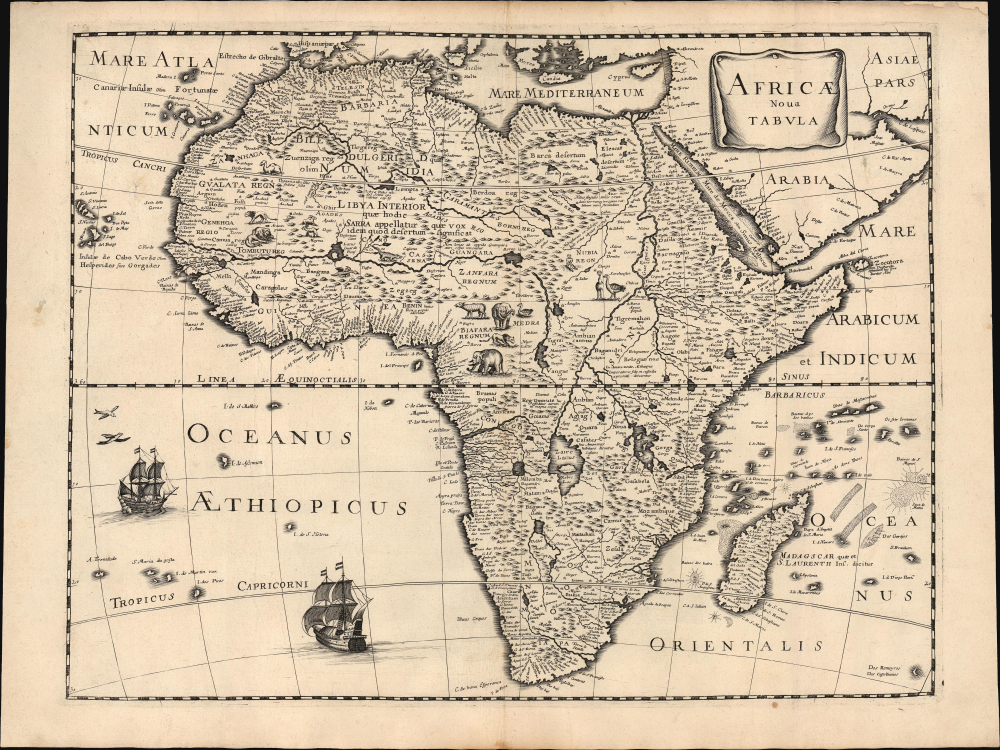
This is Peter Mariette's 1650 map of Africa, published in his Theatre Géographique de France. The present example is a rare French edition that does not appear in OCLC and has appeared only twice on the market since 2008.
A Long-Lived and Influential Mapping
This map's geography originally appeared in the 1619 Africae nova Tabula of Jodocus Hondius Jr. as part of his set of four continent maps and remained a staple of the Hondius/Janssonius atlases. It was widely copied: Bertius, Tavernier, Boisseau, and Berey all produced works based on this map, as did Mariette. The present map of Africa - though anonymous - is attributed to Peter Mariette, who included it in his 1650 Theatre Géographique de France. Although published in Paris, the map's geography and decorative elements are Dutch, leading some to believe it to have been engraved by Cornelis Danckerts.A Closer Look
The map's cartography follows Hondius' original both in terms of detail and execution. The coastline, in particular, is rich in toponomy, and the overall shape of the continent is accurate. Points within the continent, nonetheless, reveal the European ignorance of Africa's interior that would remain largely unchanged until well into the 19th century. The Nile, for example, is illustrated with its sources in the lakes of Zaire and Zaflan, an assumption inherited from no less venerable an authority than the 2nd-century Alexandrian geographer Claudius Ptolemy. The equally fictitious Lake Sachaf, derived from Laurent Fries' 1522 geography, appears in southern Africa, feeding the Zambere River, which flows to the Rio de Spirito Santo. The Cuama River is shown north of the Rio de Spirito Santo, but unlike earlier maps (including the 1608 Blaeu wall map), the Cuama is given its own source rather than sharing Lake Sachaf. The Niger River is shown running, essentially, in the wrong direction, emptying into the Senegal River after having flowed from a supposed Lake Niger (a misunderstanding of the Niger Inland Delta?) in the general vicinity of what is now the Central African Republic. (The detailed mapping of the Niger River would not be complete until the 1890s.) The map is embellished with lions, zebras, elephants, ostriches, and camels. There is even, south of the Niger River, a dragon. Flying fish skim the waters west of Guinea, and two ships sail the Oceanus Aethiopicus in the lower left quadrant of the map.Publication History and Census
Betz attributes the work to Pierre Mariette, who included it in his c. 1650 Theatre Géographique de France. This map's engraver is unknown, but Betz proposes Cornelis Danckerts, who collaborated with Mariette on the 1647 Totius Africae Nova et Exacta. The map is rare. There are no examples cataloged in OCLC, and it has only appeared on the market twice since 2008.CartographerS
Pierre Mariette (1569 - 1657) was a French publisher and engraver active in Paris during the first half of the 19th century. Mariette established himself as successful publisher of art prints, but decided to turn his energy to cartography with the purchase of the plates for Melchior Tavernier's maps in 1644. Tavernier had partnered with Sanson before his death and Mariette followed suit. Around 1644- 1648 Mariette partnered with Nicolas Sanson, a then nascent figure in French cartography, to produce folio maps and atlases. The Sanson-Mariette relationship depended upon Sanson to draw and obtain rights for the maps while Mariette engraved them and paid for the expensive printing process. The two then shared rights to the maps into perpetuity. The finished copper plates were split between two such that neither could publish an atlas without the other's assent. The relationship seemed reasonably amicable until Mariette's death in 1657, when disputes arose between Sanson and Mariette's heirs. A court battle finally returned the most of the plates to Sanson's own heirs in 1674. As a consequence, some printings feature the Mariette imprint, others the Sanson imprint, and still others both imprints. More by this mapmaker...
The Danckerts family (fl. 1628 - 1717) were a Dutch engraving and cartographic publishing firm active in Amsterdam during the latter half of the 17th and early 18th centuries. The firm was founded by Cornelis Dankerts II (1603-1656) and his brother Dancker Danckerts (1614-16?). Cornelius and Dancker published few maps, but did pass the business on to Cornelius' son Justus Danckerts (1635 - 1701) and grandsons Theodorus Danckerts (1663-1727) and Cornelius Danckerts III (1664-1717). The firm was most active in this period between 1680 and 1700 when a number of atlases and maps appeared bearing either the Justus Danckerts or Theodorus Danckerts imprint. At the time, it was in vogue in Amsterdam to leave maps undated, which makes Danckerts maps particularly difficult to ascribe. Similarly, there is a considerable corpus of maps signed as Cornelius Danckerts. When dated we can correctly attribute these to either Cornelius II or Cornelius III, though, typically, most are undated and consequently difficult to attach to the correct Danckerts family member. The Danckerts family is well known for its highly detailed and graphic engraving style. In addition to numerous atlas maps, they also produced a number of spectacular Dutch wall maps. In the early 18th century, the Danckerts map plates were purchased by R. and J. Ottens, who reprinted many of them under their own imprint. (Ref: Keuning, J., "Cornelis Danckerts and his "Niew Aerdsh Pleyn"", Imago Mundi, Vol. 12 (1955), pp. 136-139.) Learn More...
Source
Mariette, P., Theatre Geographique de France, (Paris: Mariette) 1650.
Condition
Very good. Upper margin reinforced and recornered, else excellent.
References
Betz, R., The Mapping of Africa #80.