Digital Image: 1786 Tofiño Nautical Chart or Map of Gibraltar and the Bay of Gibraltar
AlgecirasGibraltar-tofino-1786_d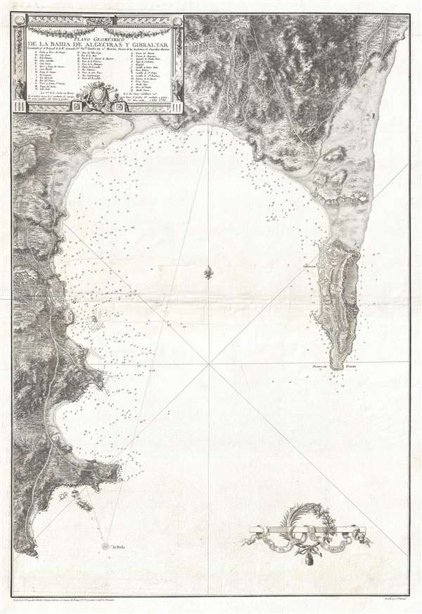

Title
Plano Geométrico de la Bahia de Algeciras y Gibraltar.
1786 (dated) 31.25 x 21.25 in (79.375 x 53.975 cm) 1 : 25000
1786 (dated) 31.25 x 21.25 in (79.375 x 53.975 cm) 1 : 25000
Description
FOR THE ORIGINAL ANTIQUE MAP, WITH HISTORICAL ANALYSIS, CLICK HERE.
Digital Map Information
Geographicus maintains an archive of high-resolution rare map scans. We scan our maps at 300 DPI or higher, with newer images being 600 DPI, (either TIFF or JPEG, depending on when the scan was done) which is most cases in suitable for enlargement and printing.
Delivery
Once you purchase our digital scan service, you will receive a download link via email - usually within seconds. Digital orders are delivered as ZIP files, an industry standard file compression protocol that any computer should be able to unpack. Some of our files are very large, and can take some time to download. Most files are saved into your computer's 'Downloads' folder. All delivery is electronic. No physical product is shipped.
Credit and Scope of Use
You can use your digial image any way you want! Our digital images are unrestricted by copyright and can be used, modified, and published freely. The textual description that accompanies the original antique map is not included in the sale of digital images and remains protected by copyright. That said, we put significant care and effort into scanning and editing these maps, and we’d appreciate a credit when possible. Should you wish to credit us, please use the following credit line:
Courtesy of Geographicus Rare Antique Maps (https://www.geographicus.com).
How Large Can I Print?
In general, at 300 DPI, you should at least be able to double the size of the actual image, more so with our 600 DPI images. So, if the original was 10 x 12 inches, you can print at 20 x 24 inches, without quality loss. If your display requirements can accommodate some loss in image quality, you can make it even larger. That being said, no quality of scan will allow you to blow up at 10 x 12 inch map to wall size without significant quality loss. For more information, it is best consult a printer or reprographics specialist.
Refunds
If the high resolution image you ordered is unavailable, we will fully refund your purchase. Otherwise, digital images scans are a service, not a tangible product, and cannot be returned or refunded once the download link is used.
Cartographer S
Vincente Tofiño de San Miguel (September 6, 1732 - 1795) was a Spanish naval officer and hydrographer active in the second half of the 18th century. Tofiño was born in Cadiz, Spain. His father, a career army officer, died in the 1746 Battle of Placentia, leaving Vincente an orphan from age 14. He moved to Extremadura where his uncle, a priest, raised him. In 1750, following in his father's footsteps, he joined the army. Having discovered a proficiency in mathematics, Tofiño was assigned to an artillery unit. In 1755, moving from the army to the navy, where his skills were better suited, he became a professor of mathematics at the Academia de Guardia Marinas de Cádiz. He would remain in the navy for the subsequent 30 years, ultimately attaining the rank of Rear Admiral. Between 1783 and 1788, as a navy officer, astronomer, and hydrographer, he was deployed to survey the Mediterranean ports of Spain, the Balearic Islands, and the Barbary Coast. He trained the explorers Dionisio Alcalá Galiano and Cayetano Valdés y Flores Bazán, who named Tofino Inlet, in Vancouver, after him. Tofiño was elected correspondent of the Spanish Academy of History and of the French and Portuguese Academies of Science. He died in Cadiz in 1795. More by this mapmaker...
Juan Antonio Salvador Carmona (February 7, 1740 - January 20, 1805) was a Spanish engraver. Born in Nava del Rey to Pedro Salvador and María García, he was the youngest of three brothers. His two older brothers, Manuel and José, went to Madrid to study under their uncle Luis Salvador Carmona, a sculptor for the King's court. Juan spent his childhood wit his parents, where he trained in drawing under their guidance. At fifteen, however, Carmona traveled to Spain to join his brothers and his uncle, and changed his last name from García to Salvador Carmona, which he would go by for the rest of his life. In 1758, Carmona's brother Manuel left to study at the Academy of San Fernando in Paris, while he stayed in Madrid with his uncle. It was around this time that Carmona began to move away from sculpture and more definitively toward engraving. He left his uncle's studio and went to the workshop of Tomás López, a well-known map engraver, who had known his brother in Paris. It was during his two time with López that Carmona moved exclusively to engraving. After his brother returned from Paris in 1763, Carmona and Manuel began working together. Carmona continued to improve, and in 1770 he submitted some of his work to the Academia de San Fernando, and, following a vote, he was appointed Supernumerary Scholar. After this, his career truly began to take off. He worked for a lot of printers, creating various different works. Between 1778 and 1780 he produced 41 plates for the Apostles and Father of the Church designed by Antonio Ganzález Velázquez. This project was intended to contain portraits of all the saints, but was discontinued when it proved not to be profitable. In 1786, Carmona finished a set of Four Continents, which he dedicated to Prince Charles. Thanks to this action, he was appointed Chamber Engraver of the Prince, a title which had not existed until then. When Prince Charles ascended to the throne as Carlos IV, Carmona was made the Engraver of Camera and sworn in in 1790. Also in 1786, Carmona produced at least two plates for the Atlas of Vincente Tofiño San Miguel, and Carmona published his autobiography in 1795, the last real information available about this very successful artist. His last known engraving was produced in 1802. The exact date of Carmona's death is uncertain, as a file of his kept in the Royal Palace records his death as occurring in 1804, but the historian Manuel Ossorio y Bernard states that Carmona died on January 20, 1805. Learn More...
References
OCLC 165181548.