Digital Image: 1904 Bartholomew Map of Arabian Peninsula
Arabia-bartholomew-1904_d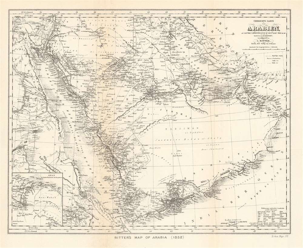

Title
Ritter's Map of Arabia (1852).
1904 (undated) 10.25 x 12.5 in (26.035 x 31.75 cm) 1 : 10000000
1904 (undated) 10.25 x 12.5 in (26.035 x 31.75 cm) 1 : 10000000
Description
FOR THE ORIGINAL ANTIQUE MAP, WITH HISTORICAL ANALYSIS, CLICK HERE.
Digital Map Information
Geographicus maintains an archive of high-resolution rare map scans. We scan our maps at 300 DPI or higher, with newer images being 600 DPI, (either TIFF or JPEG, depending on when the scan was done) which is most cases in suitable for enlargement and printing.
Delivery
Once you purchase our digital scan service, you will receive a download link via email - usually within seconds. Digital orders are delivered as ZIP files, an industry standard file compression protocol that any computer should be able to unpack. Some of our files are very large, and can take some time to download. Most files are saved into your computer's 'Downloads' folder. All delivery is electronic. No physical product is shipped.
Credit and Scope of Use
You can use your digial image any way you want! Our digital images are unrestricted by copyright and can be used, modified, and published freely. The textual description that accompanies the original antique map is not included in the sale of digital images and remains protected by copyright. That said, we put significant care and effort into scanning and editing these maps, and we’d appreciate a credit when possible. Should you wish to credit us, please use the following credit line:
Courtesy of Geographicus Rare Antique Maps (https://www.geographicus.com).
How Large Can I Print?
In general, at 300 DPI, you should at least be able to double the size of the actual image, more so with our 600 DPI images. So, if the original was 10 x 12 inches, you can print at 20 x 24 inches, without quality loss. If your display requirements can accommodate some loss in image quality, you can make it even larger. That being said, no quality of scan will allow you to blow up at 10 x 12 inch map to wall size without significant quality loss. For more information, it is best consult a printer or reprographics specialist.
Refunds
If the high resolution image you ordered is unavailable, we will fully refund your purchase. Otherwise, digital images scans are a service, not a tangible product, and cannot be returned or refunded once the download link is used.
Cartographer
The Bartholomew Family (fl. c. 1810 - 1920) is clan of map publishers active in London through the 19th century. They represent one of the great names in British cartography. The cartographic story of the Bartholomew family begins with George Bartholomew (January, 8 1784 - October 23, 1871, active from 1797), an engraver in the employ of the Daniel Lizars firm of Edinburgh. George was the first of six generations in the Bartholomew map-making dynasty. It was his son, John Bartholomew Sr. (1805 - April 9, 1861) who ultimately founded John Bartholomew and Sons in 1828. The John Bartholomew firm produced thousands of maps and rose to become one of the largest and most prolific cartography firms in Scotland. John Sr. was succeeded by his son, also John Bartholomew Jr. (1831-93). John George Bartholomew (1860-1920), son of John Bartholomew (1831-93) took control of the firm at its height. John George was a charter member of the Royal Scottish Geographical Society and supported the creation of a National Institute of Geography - a good idea that never took off. John George is also reliably attributed to be the first to bring the term "Antarctica" into popular usage as a denominator for the Southern Continent. In recognition of his work, John George was awarded a warrant from the king and often used the title "Cartographer to the King" on his imprint. Among his friends and admirers he was referred to as the "Prince of Cartography". John (Ian) Bartholomew (1890 - 1962) continued the family business and oversaw publication of the Times Survey Atlas of the World in 1922 and the Mid Century Edition of the Time Atlas of the World from 1955 - 1960. John Christoper Bartholomew (1923 - 2008) continued the family business into a fifth generation and was fascinated by the natural sciences. He spearheaded the publication of many of the most detailed and popular maps of the last century. His brother Robert, a trained printer, became production director. Another brother, Peter, an accountant, started as a managing director and eventually became executive chairman. The John Bartholomew firm has been part of the HarperCollins family of publishers since 1989. The vast archive of maps and atlases produced by the Bartholomew family has since been transferred to the National Library of Scotland where it is currently in the cataloguing process. More by this mapmaker...
Carl Ritter (August 7, 1779 - September 28, 1859) was a German geographer. Born in Quedlinburg, Ritter attended the Schnepfenthal Salzmann School from the age of five. This school, which focused on the study of nature, would influence Ritter for the rest of his life. Ritter was introduced to Bethmann Hollweg, a banker from Frankfurt, after he graduated. Hollweg soon arranged for Ritter to tutor his children, in exchange for which Ritter would attend the University of Halle at Hollweg's expense. Ritter began tutoring Hollweg's children in 1798 and continued to do so for the following fifteen years. He even spent 1814 - 1819 in Göttingen to continue this work, which is also when Ritter began to devote himself exclusively to the study of geography. He also married his wife Lilli Kramer and wrote the first two volumes of his masterwork, Erdkunde, during his time in Göttingen. Ritter was named professor of history at the University of Frankfurt in 1819 and gained a position in the history department at the University of Berlin the following year. Ritter received his doctorate from the University of Berlin in 1821 and was appointed the first professor of geography there in 1825. He was elected to the Prussian Academy of Sciences in 1822 and became a corresponding member of the Société Asiatique de Paris two years later. Ritter founded the Berlin Geographical Society (Gesellschaft für zu Berlin) in 1828 and in 1849 was elected a Foreign Honorary Member of the American Academy of Arts and Sciences. He was appointed curator of the Royal Cartographic Institute of Prussia in 1856 and died in Berlin in 1859. His masterwork, Erdkunde im Verhältnis zur Natur und zur Geschichte des Menschen oder allgemeine, vergleichende Geographie, als sichere Grundlage des Studiums und Unterricts in physicalischen und historischen Wissenschaften, consists of 19 parts and 21 volumes, and is one of the most extensive works of geography written by a single author. Learn More...
Source
Hogarth, D.G., The Penetration of Arabia (New York: Frederick A. Stokes Company) 1904.