This item has been sold, but you can get on the Waitlist to be notified if another example becomes available, or purchase a digital scan.
1865 Petermann Map of the Arctic and Antarctic Discovery
ArticAntarcticDiscovery-petermann-1865$187.50

Title
Karte der Arktischen und Antarktischen Regionen zur Übersicht der Entdeckungsgeschichte. / Map of the Arctic and Antarctic Regions for the Overview of the History of Discovery.
1865 (dated) 10.25 x 18 in (26.035 x 45.72 cm) 1 : 40000000
1865 (dated) 10.25 x 18 in (26.035 x 45.72 cm) 1 : 40000000
Description
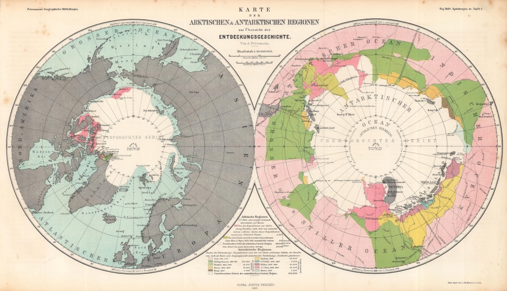
Consisting of two polar projection maps on one sheet, this is an 1865 Augustus Petermann map of the Arctic and Antarctic. Both maps highlight areas recorded by European explorers beginning in the 1770s through the 1860s. Islands, straits, bays, seas, and other locations are noted in both regions. A key explaining the various colors employed is situated at bottom center.
The Arctic
Most of the Arctic map (on the left) is colored blue, which denotes regions that are 'more or less known'. The pink areas west of Hudson Bay are areas explored by the (unsuccessful) expeditions to find Sir John Franklin's lost 1848 Arctic expedition. The small green area in the Kennedy Channel highlights the territory explored by the two Kane and Hayes expeditions between 1853 and 1861. The white areas at center are the unexplored regions, which Petermann notes are larger than the entire continent of Australia.The Antarctic
On the Antarctic map (on the right), routes followed by explorers and areas covered by these expeditions are detailed. Among the included explorers are Cook, Weddel, d'Urville, Wilkes, J.C. Ross, and Moore. Areas recorded by each expedition are provided in German square miles, with the total unexplored area numbering 396,000 square miles.Publication History and Census
This map was created by Augustus Petermann, lithographed by Carl Hellfarth, and published by Justus Perthes in Spitzbergen und die Arktische Central Region. Eine Reihe von Aufsätzen und Karten als Beitrag zur Geographie und Erforschung der Polar-Regionen in 1865. We note three examples of the separate map cataloged in OCLC which are part of the collections at The British Library, the Bibliothèque nationale de France, and the Bayerische Staatsbibliothek. It rarely appears on the private market.CartographerS
August Heinrich Petermann (1822 - 1878) was a German cartographer. Petermann attended the 'Geographische Kuntschule' (Geographica School of Art), which was started by Heinrich Berghaus with the support of Alexander von Humboldt, in Potsdam beginning in 1839. Students at the school were obliged to work on many of the school's contracts, including maps for several different atlases. Following his time in Potsdam, Petermann relocated to Edinburgh and London from 1845 to 1854, where he gained insight into the commercial aspects of the cartography business. In 1854, Petermann returned to Gotha, Germany and began working with the Perthes brothers publishers. While working with the Perthes brothers, Petermann founded the journal Petermanns Geographische Mitteilungen, published from 1855 until 2014, long one of the most prominent German-language geography journals. More by this mapmaker...
Johan Georg Justus Perthes (September 11, 1749 - May 2, 1816) was one of the most important German cartographic engravers of the 19th century. He was born in the Thuringian town of Rudolstadt, the son of a court physician. In 1778, he began working as a bookseller in Gotha. Perthes began his publishing empire shortly thereafter with the 1784 issue of the famed survey of European nobility known as the Almanac de Gotha. In the next year, 1785, he founded the cartographic firm of Justus Perthes Geographische Anstalt Gotha. His son Wilhelm Perthes (1793 - 1853) joined the firm in 1814. Wilhelm had prior publishing experience at the firm of Justus Perthes' nephew, Friedrich Christoph Perthes, who ran a publishing house in Hamburg. After Justus Perthes died in 1816, Wilhelm took charge and laid the groundwork for the firm to become a cartographic publishing titan. From 1817 to 1890. the Perthes firm issued thousands of maps and more than 20 different atlases. Along with the visionary editors Hermann Berghaus (1797 - 1884), Adolph Stieler (1775 - 1836), and Karl Spruner (1803 - 1892), the Perthes firm pioneered the Hand Atlas. When Wilhelm retired, management of the firm passed to his son, Bernhardt Wilhelm Perthes (1821 – 1857). Bernhardt brought on the cartographic geniuses August Heinrich Peterman (1822 - 1878) and Bruno Hassenstein (1839 - 1902). The firm was subsequently passed to a fourth generation in the form of Berhanrd Perthes (1858 – 1919), Bernhard Wilhelm's son. The firm continued in the family until 1953 when, being in East Germany, it was nationalized and run as a state-owned enterprise as VEB Hermann Haack Geographisch-Kartographische Anstalt Gotha. The Justus family, led by Joachim Justus Perthes and his son Wolf-Jürgen Perthes, relocated to Darmstadt where they founded the Justus Perthes Geographische Verlagsanstalt Darmstadt. Learn More...
Carl Hellfarth (November 30, 1846 - July 12, 1918) was a German printer. Hellfarth was born in Gotha, Germany. He married Amalie Friederike Marie Möller (1850 - 1916) on June 16, 1873, and they had eight children. Learn More...
Source
Petermann, A., Spitzbergen und die Arktische Central Region. Eine Reihe von Aufsätzen und Karten als Beitrag zur Geographie und Erforschung der Polar-Regionen, (Gotha: Perthes) 1865.
Condition
Very good. Light wear along original fold lines. Light foxing.
References
OCLC 556378478, 163821077.