Digital Image: 1859 Purdy / Vidal Chart of the Azores, Portugal
Azores-purdy-1859_d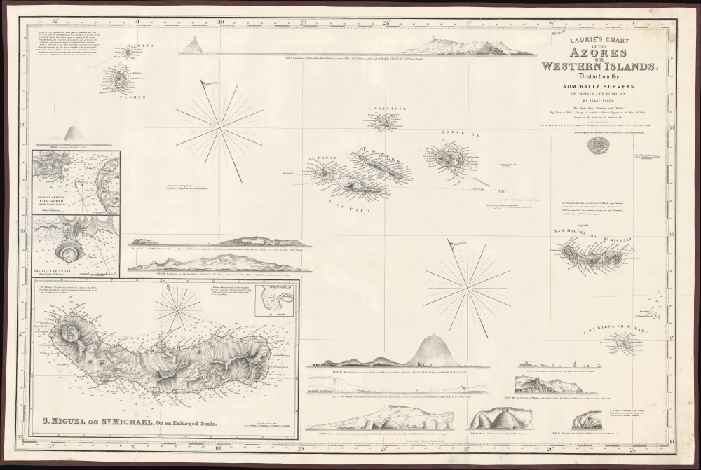

Title
Laurie's Chart of the Azores or Western Islands.
1859 (dated) 37 x 24.5 in (93.98 x 62.23 cm)
1859 (dated) 37 x 24.5 in (93.98 x 62.23 cm)
Description
FOR THE ORIGINAL ANTIQUE MAP, WITH HISTORICAL ANALYSIS, CLICK HERE.
Digital Map Information
Geographicus maintains an archive of high-resolution rare map scans. We scan our maps at 300 DPI or higher, with newer images being 600 DPI, (either TIFF or JPEG, depending on when the scan was done) which is most cases in suitable for enlargement and printing.
Delivery
Once you purchase our digital scan service, you will receive a download link via email - usually within seconds. Digital orders are delivered as ZIP files, an industry standard file compression protocol that any computer should be able to unpack. Some of our files are very large, and can take some time to download. Most files are saved into your computer's 'Downloads' folder. All delivery is electronic. No physical product is shipped.
Credit and Scope of Use
You can use your digial image any way you want! Our digital images are unrestricted by copyright and can be used, modified, and published freely. The textual description that accompanies the original antique map is not included in the sale of digital images and remains protected by copyright. That said, we put significant care and effort into scanning and editing these maps, and we’d appreciate a credit when possible. Should you wish to credit us, please use the following credit line:
Courtesy of Geographicus Rare Antique Maps (https://www.geographicus.com).
How Large Can I Print?
In general, at 300 DPI, you should at least be able to double the size of the actual image, more so with our 600 DPI images. So, if the original was 10 x 12 inches, you can print at 20 x 24 inches, without quality loss. If your display requirements can accommodate some loss in image quality, you can make it even larger. That being said, no quality of scan will allow you to blow up at 10 x 12 inch map to wall size without significant quality loss. For more information, it is best consult a printer or reprographics specialist.
Refunds
If the high resolution image you ordered is unavailable, we will fully refund your purchase. Otherwise, digital images scans are a service, not a tangible product, and cannot be returned or refunded once the download link is used.
Cartographer S
Isaac Purdy 2 (fl. c. 1840 - 1869) was an English engraver and publisher of Blueback nautical charts active in the middle part of the 19th century. Purdy is presumed to be grand-nephew of the earlier generation map publisher John Purdy (1773 - 1843). He was active until at least 1869, possibly later, and should not be confused with the Admiralty Hydrography Isaac Purdy 1 (1804 - 1852). More by this mapmaker...
Vice Admiral Alexander Thomas Emeric Vidal (1792- 5 February 1863) was an officer of the Royal Navy and an accomplished surveyor. Vidal, the youngest of four children, followed his father into the Navy. He began his naval career in December 1803, at the age of 11, as a 1st class volunteer. He served until 1805 when he joined the Royal Naval College at Portsmouth. He was assigned to the HMS Lavinia and spent three years aboard as a midshipman. He received his first commission in 1815 and was appointed to HMS Leven in 1818 as a first lieutenant under William Fitzwilliam Owen. Vidal accompanied Owen on his voyage to Africa to map the eastern coast. Vidal received his first command in May 1823, while one the expedition with Owen, that of HMS Barracuda.
Vidal spent most of his career as a surveyor, who was charged with several tasks, including locating Aitken’s Rock, a rock supposedly in the North Atlantic. There were at least seven different reports of the potential hazard, stating that it was small and protruded only about four feet from the surface of the ocean. In 1830, Vidal was dispatched to find the rock and accurately chart its location. After six weeks of charting supposed locations, Vidal was unable to locate it. However, during the hunt for Aitken’s Rock, Vidal successfully discovered and charted Vidal bank, and the following year was the first to accurately chart and describe Rockall, a nearly 60 foot high islet in the North Atlantic. The United Kingdom claimed the islet in his name in 1955. Learn More...
Richard Holmes Laurie (December 2, 1777 - January 19, 1858) was a British map and chart publisher and seller. Born in London to publisher Robert Laurie and his wife Esther Jouret, R. H. Laurie took over his father's share of the Laurie and Whittle publishing firm upon his father's retirement in 1812 and began trading as Whittle and Laurie. After Whittle died in 1818, Laurie continued the business by himself, trading under the imprint R. H. Laurie. During the 1820s and 1830s, Laurie expanded the nautical chart business until he was overtaken by Admiralty charts. Laurie married Susan Ann Coates on February 6, 1814 and later married Mary Ann Dennison on October 15, 1833. He left his business and all his property in trust for his two surviving daughters (both of whom were minors) with his principal engraver, Alexander George Findlay. Findlay continued the business in Laurie's name after acquiring its equity from his daughters. Learn More...
References
Museu Marítim de Barcelona Núm Registre: 583C.