Digital Image: 1850 Derby Map of Riley's Travels in the California Gold Region
CaliforniaMining-derby-1850_d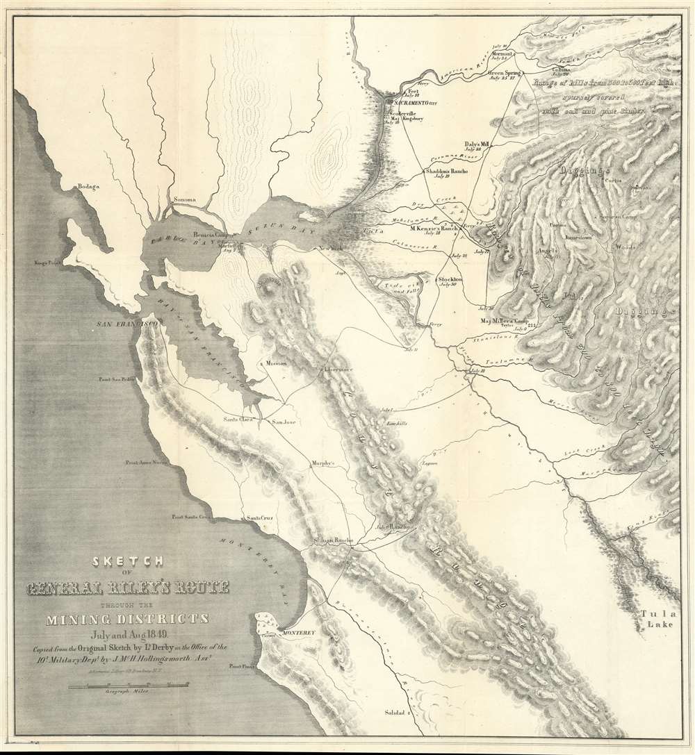

Title
Sketch of General Riley's Route Through the Mining Districts July and Aug 1849.
1850 (dated) 21.75 x 20 in (55.245 x 50.8 cm) 1 : 550000
1850 (dated) 21.75 x 20 in (55.245 x 50.8 cm) 1 : 550000
Description
FOR THE ORIGINAL ANTIQUE MAP, WITH HISTORICAL ANALYSIS, CLICK HERE.
Digital Map Information
Geographicus maintains an archive of high-resolution rare map scans. We scan our maps at 300 DPI or higher, with newer images being 600 DPI, (either TIFF or JPEG, depending on when the scan was done) which is most cases in suitable for enlargement and printing.
Delivery
Once you purchase our digital scan service, you will receive a download link via email - usually within seconds. Digital orders are delivered as ZIP files, an industry standard file compression protocol that any computer should be able to unpack. Some of our files are very large, and can take some time to download. Most files are saved into your computer's 'Downloads' folder. All delivery is electronic. No physical product is shipped.
Credit and Scope of Use
You can use your digial image any way you want! Our digital images are unrestricted by copyright and can be used, modified, and published freely. The textual description that accompanies the original antique map is not included in the sale of digital images and remains protected by copyright. That said, we put significant care and effort into scanning and editing these maps, and we’d appreciate a credit when possible. Should you wish to credit us, please use the following credit line:
Courtesy of Geographicus Rare Antique Maps (https://www.geographicus.com).
How Large Can I Print?
In general, at 300 DPI, you should at least be able to double the size of the actual image, more so with our 600 DPI images. So, if the original was 10 x 12 inches, you can print at 20 x 24 inches, without quality loss. If your display requirements can accommodate some loss in image quality, you can make it even larger. That being said, no quality of scan will allow you to blow up at 10 x 12 inch map to wall size without significant quality loss. For more information, it is best consult a printer or reprographics specialist.
Refunds
If the high resolution image you ordered is unavailable, we will fully refund your purchase. Otherwise, digital images scans are a service, not a tangible product, and cannot be returned or refunded once the download link is used.
Cartographer S
George Horatio Derby (April 3, 1823 - May 15, 1861) was an American military officer, topographical engineer, and humorist. Derby was born in Dedham, Massachusetts to a wealthy family dedicated to the arts rather than commerce. He graduated from the U.S. Military Academy at West Point in 1846 - just in time to serve in the Mexican American War (1846 - 1848), where he saw action at Veracruz and Cerro Gordo. After the war he was stationed with the Topographical Engineers in California under General Bennet C. Riley (1787 - 1853). He accompanied Riley on his travels throughout the region, serving as a mapmaker and topographer. Later, in 1853, he was sent to San Diego to map the San Diego River and San Diego Bay. Darby was known for an erratic, flippant manner that both endeared and infuriated his superiors. It may have been during his tenure in San Diego that Derby developed as a humorist. Under the pseudonyms 'John P. Squibob' and 'John Phoenix', Derby contributed mocking articles that poked fun at the pretensions of the social elite to the San Francisco Herald, California Pioneer, and the struggling local newspaper, the San Diego Herald. He used his family resources to purchase the San Diego Herald in 1855, but perhaps due to his military commitments, was unable to make it profitable, and it folded in 1860. Darby himself began exhibiting health problems, including vision loss and headaches, possibly related to a brain tumor, in 1857. He requested leave from the Topographical Engineers in 1859, citing poor health, and moved to New York, where he died shortly after the start of the American Civil War. More by this mapmaker...
Ackermann (1795 - 199x) was a British publishing firm founded by Rudolph Ackermann (April 20, 1764 - March 30, 1834). First known as R. Ackermann and Company, Ackermann's three sons took over the business when their father retired. The firm was known as A. Ackermann and Son in the early 20th century and had offices in London, Paris, New York, and Chicago. Their New York office was exceptionally prolific, issuing work for both the private and government sectors. Ackermann was acquired in late 1990s and the imprint resurrected. Learn More...
References
Library of Congress, G4360 1849 .D4. OCLC 84712214. Wheat, C. I., The Maps of the California Gold Region, 1848-1857: A Biblio-Cartography of an Important Decade, #79.