
Ackermann

Ackermann (1795 - 199x) was a British publishing firm founded by Rudolph Ackermann (April 20, 1764 - March 30, 1834). First known as R. Ackermann and Company, Ackermann's three sons took over the business when their father retired. The firm was known as A. Ackermann and Son in the early 20th century and had offices in London, Paris, New York, and Chicago. Their New York office was exceptionally prolific, issuing work for both the private and government sectors. Ackermann was acquired in late 1990s and the imprint resurrected.
A Landmark Case for Animal Rights.
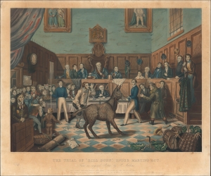
The Trial of 'Bill Burn,' Under Martin's Act.
$1,500.00
Acquire
- Digital Map Information
- Suitable for large format printing
- Full resolution TIFF file
- ICC color profile embedded
- Delivered instantly via download link
A scarce c. 1840 satirical print dealing with the 1822 trial of Bill Burns that was engraved by Charles Hunt, overseen by Ackermann and Co., and published by P. Mathews in Stourbridge. The Burns case was the first to be tried after the passage of Martin's Act (Cruel Treatment of Cattle Act), a landmark law against animal cruelty. (more details)
Oh how things have changed.
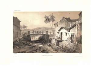
Vue Prise a Sincapour.
$1,000.00
Acquire
- Digital Map Information
- Suitable for large format printing
- Full resolution TIFF file
- ICC color profile embedded
- Delivered instantly via download link
One of the earliest obtainable views of Singapore, this c. 1840 image was drawn by Barthélemy Lauvergne. The 2-color chromolithograph view likely looks east along Singapore River with the old bridge on South Bridge Road at center. Beyond, Battery Point with a hint of fortifications is evident. The low water level and dock extending into empty space underscores that this view was done during the dry season. The Chinese Campong is on the right - note the Chinese characters above the door.
Lauvergne was one of several artists accompanying the 1836 - 1837 Auguste-Nicolas Vaillant (1793 - 1858) circumnavigation. The scientific expedition arrived in Singapore on February 17, 1837 and stayed through February 23rd. It is safe to assume that Lauvergne sketched this view during the expedition's brief stay. (more details)
Lauvergne was one of several artists accompanying the 1836 - 1837 Auguste-Nicolas Vaillant (1793 - 1858) circumnavigation. The scientific expedition arrived in Singapore on February 17, 1837 and stayed through February 23rd. It is safe to assume that Lauvergne sketched this view during the expedition's brief stay. (more details)
A pleasant pastoral view of early Singapore.
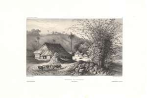
Environs de Sincapour, Détroit de Malacca.
$700.00
Acquire
- Digital Map Information
- Suitable for large format printing
- DPI: 600
- File Size: 26.45 MB
- File Type: ZIP / TIFF
- ICC color profile embedded
- Delivered instantly via download link
This is a rare c. 1845 chromolithograph of a rural scene in the early days of British Singapore by Barthélémy Lauvergne, one of the resident artists on the Bonite Expedition (1836 - 1837), a French scientific and diplomatic circumnavigation. (more details)
An early depiction of Nuʻuanu Pali, the gateway to Honolulu.
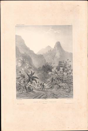
Vallée du Pari près Honoloulou, Iles Sandwich.
$500.00
Acquire
- Digital Map Information
- Suitable for large format printing
- Full resolution TIFF file
- ICC color profile embedded
- Delivered instantly via download link
This is a rare 1845 lithograph view of Nuʻuanu Pali, a cliff face and mountain pass in at the head of the Nuʻuanu Valley near Honolulu, Hawaii. This historically and culturally important site is depicted here by Théodore Auguste Fisquet, one of the designated ship artists for the Bonite expedition, an 1836 - 1837 French voyage around the world. (more details)
Early reconnaissance of the California Gold Region.
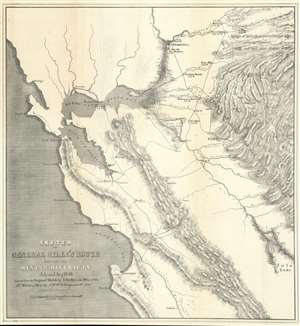
Sketch of General Riley's Route Through the Mining Districts July and Aug 1849.
$650.00
Acquire
- Digital Map Information
- Suitable for large format printing
- Full resolution TIFF file
- ICC color profile embedded
- Delivered instantly via download link
This is an uncommon California Gold Rush Era map of the gold regions to the west of San Francisco Bay, California. The map follows the 1849 expedition of General Bennet C. Riley (1787 - 1853), California's first 'civilian' governor, to gather important reconnaissance of the gold diggings and mining at the height of the Gold Rush. Although the full mining area is not encapsulated, coverage is extensive, ranging from the Pacific Coast to the western Sierra Nevada Range, and from just north of Sacramento to Tule Lake. The map notes the diggings along the America River, early roads, towns, rivers, etc., including Scollerville, Green Spring, Colluma, Jonestone, Corons, Angel's, Sororam Camp, Sullivan's, Curtis, Woods, Tent, Maj. Miller's Camp, M. Kenzie's Ranch, Stockton, Daly's Mill, etc. (more details)
A beautiful view of a church that burned during the 1871 Great Chicago Fire.
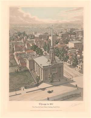
Chicago in 1857. View from the Court House looking South West.
$900.00
Acquire
- Digital Map Information
- Suitable for large format printing
- File Size: 14.45 MB
- File Type: ZIP / TIFF
- ICC color profile embedded
- Delivered instantly via download link
This is a 1930 Raoul Varin aquatint view of the First Baptist Church at the corner of Washington and South LaSalle Streets in Chicago, Illinois, as it appeared in 1857. The view looks southwest over Chicago from the top of the courthouse. The First Baptist Church dominates the foreground, while individual buildings and trees line South LaSalle Street. Ship masts are visible along the Chicago River. Both the courthouse and the First Baptist Church burned during the Great Chicago Fire of October 8-10, 1871. (more details)