1708 Cellarius Celestial Map illustrating the Spheres
CelestialCircles-valk-1708$1,800.00

Title
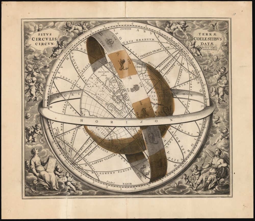
Situs Terrae Circulis Coelestibus Circundatae.
1708 (undated) 17 x 20 in (43.18 x 50.8 cm)
1708 (undated) 17 x 20 in (43.18 x 50.8 cm)
Description
This beautiful work is Andreas Cellarius' celestial chart, in its 1708 Valk and Schenk edition, illustrating the position of the Earth within the celestial sphere divided into its circles. Its lush, baroque presentation - filled with clouds, putti, and muses - frames a useful visual glossary illustrating terminology important both to the astronomer and to the geographer.
Lavish Engraving
This is among the most visually lively of Cellarius' celestial charts: surrounding the globe is a stylized armillary sphere, upon which are visible seven of the twelve signs of the Zodiac with their symbols: Cancer, Leo, Virgo, Libra, Scorpio, Sagittarius and Capricorn. Framing the chart are sumptuously engraved clouds teeming with putti, many of whom brandish cross staves, geometer's compasses, and astrolabes (emphasizing the purpose of the chart). The muses of geography and astronomy are seated at the bottom left and right. (Geometria and Urania, respectively: the former bearing a compass and celestial chart, the latter crowned with stars and leaning on an armillary sphere.)A Closer Look
Despite often being described as such, this is not a Ptolemaic model of the Universe. Specifically, the chart pictures the globe at the center of the celestial sphere, subdivided by circles describing different parts of the sky as observed from the ground. Concentric with the Earth's equator, this imaginary sphere is divided into northern and southern hemispheres by an equator; the sphere also possesses its own tropics of Cancer and Capricorn and its Arctic and Antarctic circles. The striking band sporting illustrations of the Zodiac is the zodiac: the region of the sky extending north and south of the ecliptic, embracing the apparent path of the sun across the celestial sphere.Dividing the Celestial Sphere
Note first that the chart does not reflect, at all, on the actual form of the solar system. For example, there is no note here about the relationship of the Earth to the Sun, Moon, or Planets. It specifically illustrates the concept of the celestial sphere, and its primary divisions, or circles. This was a primary astronomical concept. The oldest branch of astronomy - spherical or positional astronomy - was based on the observation of the apparent movement of objects over time in relation to the Earth. The celestial sphere - an abstract sphere with the Earth at its center - was a conceptual tool that allowed astronomers to divide the sky into coordinates analogous to how geographers divided the globe (much of the terminology is the same). While positional astronomy had been applied to both religion and astrology in antiquity, it retained utility for both timekeeping and navigation. So Cellarius' chart was not a portrayal of an antiquated system of astronomical thought but rather described essential terms useful to any astronomer, whether they were applying them to the ancient astronomy of Ptolemy or to the modern models of Tycho Brahe or Copernicus. Cellarius' Harmonia Macrocosmica contained diagrams illustrating the conflicting models of the Solar system in play during the 17th century. The concept of the celestial sphere was relevant to the study of all of these.A State of the Art Depiction of the Globe
The diagram surrounds a depiction of the globe which reflects the geographical knowledge that was current at the time the chart was engraved. The globe's position focuses on Australia, Southeast Asia, and the Pacific Ocean; to the west, the islands of the Indian Ocean are visible, as well as the Indian Peninsula; the imagined Terra Australis Incognita can be seen at the south pole. To the east - all but obscured in the globe's shadow - can be glimpsed the speculative Pacific coast of North America, including the island of California.Publication History and Census
This engraving was executed by Johannes van Loon for Jan Jansson, who in 1660 first published Cellarius' Harmonia Macrocosmica. Jansson produced two editions of the book in 1660 and 1661; these editions are distinguishable by the plate numbers engraved for the 1661 edition. Amsterdam publishers Gerard Valk and Pieter Schenk acquired the plates and republished Cellarius' work in 1708, having added their own imprint and privilege to the plates. Separate examples of Cellarius' charts appear on the market from time to time. We see fifteen examples of this plate listed in OCLC, seven of which correspond to this 1708 edition.CartographerS
Andreas Cellarius (1596 - 1665) was a Dutch-German cartographer, mathematician, and astronomer. He was born in Neuhausen (now a part of Worms), and was educated in Heidelberg. Cellarius, being Protestant, may have left Heidelberg in 1618, at the onset of the Thirty Years' War, or slightly later, in 1622, when the city fell to Catholics. His activities are unclear at this time but based on his later works it is conjectured he spent time in Poland where he may have taken work as a military engineer. In 1625. he married Catharina Eltemans in Amsterdam, where he taught Latin. After a brief stay in The Hague, the family moved to Hoorn. From 1637 until his death he was rector of the Hoorn Latin School. Today Cellarius is best known for his Harmonia Macrocosmica of 1660, a major celestial atlas, published in Amsterdam by Johannes Janssonius. More by this mapmaker...
Gerard Valk (September 30, 1652 - October 21, 1726) (aka. Valck, Walck, Valcke), was a Dutch engraver, globe maker, and map publisher active in Amsterdam in the latter half of the 17th century and early 18th century. Valk was born in Amsterdam where his father, Leendert Gerritsz, was a silversmith. He studied mathematics, navigation, and cartography under Pieter Maasz Smit. Valk and moved to London in 1673, where he studied engraving under Abraham Blooteling (or Bloteling) (1634 - 1690), whose sister he married, and later worked for the map sellers Christopher Browne and David Loggan. Valke and Blooteling returned to Amsterdam in 1680 and applied for a 15-year privilege, a kind of early copyright, from the States General, which was granted in 1684. In 1687, he established his own firm in Amsterdam in partnership with Petrus (Pieter) Schenk, who had just married his sister, Agata. They published under the imprint of Valk and Schenk. Also, curiously in the same year Valk acquired the home of Jochem Bormeester, also engraver and son-in-law of art dealer Clement De Jonghe. Initially Valk and Schenk focused on maps and atlases, acquiring the map plates of Jodocus Hondius and Jan Jansson in 1694. Later, in 1701 they moved into the former Hendrick Hondius (the younger) offices where they began producing globes. Valk and Schenk soon acquired the reputation of producing the finest globes in the Netherlands, a business on which they held a near monopoly for nearly 50 years. In 1702, Valk joined the Bookseller's Guild of which he was promptly elected head. Around the same time, Gerard introduced his son, Leonard, who was married to Maria Schenk, to the business. Leonard spearheaded the acquisition of the map plates of Frederick de Wit in 1709. Nonetheless, Leonard was nowhere near as sophisticated a cartographer or businessman as his father and ultimately, through neglect, lost much the firm's prestige. After his death, the firm was taken over by his widow Maria. Learn More...
Petrus Schenk (Pieter Schenck) the Elder (December 26, 1660 - 1711) was a Dutch engraver, globe maker, and map publisher active in Amsterdam and Leipzig in the latter half of the 17th century. Schenk, was born in Elberfield, Germany. He moved in Amsterdam in 1675, becoming the apprentice to Gerard Valk (Valck). In 1687, Schenk married Agatha Valk, Gerard Valk's sister and went into partnership with his brother-in-law under the imprint of 'Valk and Schenk'. Initially they focused on maps and atlases, acquiring the map plates of Jan Jansson and Jodocus Hondius in 1694. Later, in 1701 they moved into the former Hondius offices where they began producing globes. Valk and Schenk quickly became known for producing the best globes in the Netherlands, a business on which they held a near monopoly for nearly 50 years. Schenk's three sons, Pieter Schenk the Younger, Jan Schenk, and Leonard Schenk, all became engravers in their own right. Pieter Schenk the Younger inherited the business and ran his father's shop in Leipzig. His daughter, Maria Schenk, married Leonard Valk, the son of Gerard Valk, and continued to run the Valk and Schenk map engraving workshop in Amsterdam. Learn More...
Johannes van Loon (c. 1611 - 1686), also known as Jan van Loon, was a Dutch mapmaker, mathematician, and engraver active in Amsterdam during the middle part of the 17th century. Van Loon issued the exceptional nautical atlas Klaer-Lichtende Noort-Ster ofte Zee Atlas in 1661. His is also known to have engraved several plates of Cellarius's Harmonia Macrocosmica Seu Atlas and to have contributed maps to nautical atlases and pilot books by Jacobsz, Jan Jansson, Johannes Janssonius van Waesbergen, and Robijin. Little is known of his personal life. Learn More...
Source
Cellarius, A., Atlas Coelestis seu Harmonia Macrocosmica, (Amsterdam: Valk and Schenk) 1708.
The Atlas Coelestis; Seu Harmonia Macrocosmica is an important celestial atlas by Andreas Cellarius first published in Amsterdam by Jan Jansson in 1660. Not only is this the only celestial atlas published in Amsterdam before the 19th century, it is also the most decorative celestial atlas ever produced. The atlas was lavishly illustrated in baroque ethic and contained 29 extraordinary charts. The first 21 constitute a historical survey of cosmological theories, illustrating the motions of the sun and planets according to Claudius Ptolemy, Nicolaus Copernicus, and Tycho Brahe. The subsequent 8 plates are constellation and planetary charts. Although originally conceived of as a two volume set, the second volume never materialized. Despite criticism by prominent contemporary astronomers the first volume proved immensely popular and went through three printings, 1600, 1601, and 1666. In 1694 the Jansson plates were sold to Gerard Valk and Petrus Schenk who produced a similarly lavish edition in 1708.
Condition
Good. Mended tear at bottom, mended centerfold splits at top and bottom with no loss. Toned, original hand color.
References
OCLC 835141241. McLaughlin, Glen, The Mapping of California as an Island, 'Celestial Chart Checklist', #3.