1733 Homann Heirs Map of Southern South America (Paraguay, Chile, Argentina)
ChiliParaguay-homannheirs-1733$650.00
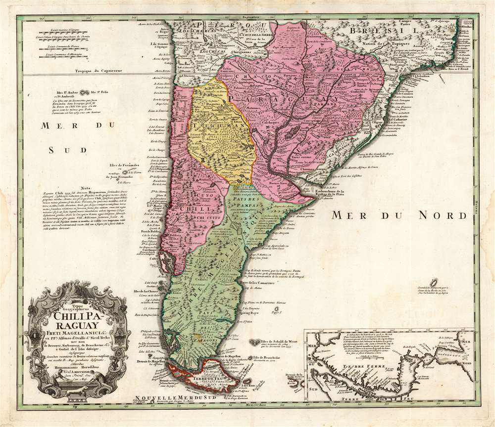

Title
Typus Geographicus Chili Paraguay Freti Magellanici etc.
1733 (dated) 19 x 22.25 in (48.26 x 56.515 cm) 1 : 9200000
1733 (dated) 19 x 22.25 in (48.26 x 56.515 cm) 1 : 9200000
Description
This is an early example of the 1733 Homann Heirs map of southern South America, in a rare first state example. It covers roughly from 18 degrees south latitude south to Tierra del Fuego, and includes the modern-day nations of Paraguay, Chile, Uruguay, and Argentina, along with the southern portions of Brazil and Bolivia. The map renders the entire region in extraordinary detail offering both topographical and political information with forest and mountains beautifully rendered in profile.
The chart at the lower right detailing the Strait of Magellan originates, not in the De l'Isle, but in Elizabeth Visscher's c. 1710 edition of De l'Isle's map; her source was a chart engraved by Jean Baptiste Liebaux, entitled Carte du Detroit de Magellan dressée sur les memoires de Mr. de la Morliere Doct.r de Sorbonne (Yet another De l'Isle connection with this work: Liebaux engraved many of Guillaume De l'Isle's early maps.) Morliere was chaplain aboard Jacques Gouin de Beauchêne's ship on his expedition to the Pacific. He had attempted in 1702 to publish a map and account of Beauchêne's expedition, which would be swiftly censored by the French Government. The suppressed map exists in only three known copies; a date of 1702 is supported by surviving correspondence between Beauchêne and the Comte du Pontchartrain.
The present map presents a broadly accurate and detailed mapping of both the east and west coasts. The Rio de la Plata is presented to suggest relatively easy navigation along it and its tributaries, as well as the relative narrowness of the continent and accessibility of the Pampas.
Some other interesting elements of this map appear far from the mainland in the surrounding seas. The Falklands are depicted in an embryonic form as identified by Captain La Roche in 1675. Just above the inset, another island appears, supposedly discovered by La Roche in 1675, and is mostly likely a mis-mapping of South Georgia Island.
Sources
The Homann firm drew on state-of-the art maps, mostly the 1703 map of Guillaume De L’Isle which, itself derived from the firsthand account of Alfonse d'Ovalle, and additional reports from de Brouwer, Narborough and, de Beauchesne. (Their copy is faithful to the extent of preserving much of De l'Isle's French commentary.) The publishers also credited Amédée-François Frézier for his reports of Peru and Chile, but it is not apparent what his contribution might have been.The present map presents a broadly accurate and detailed mapping of both the east and west coasts. The Rio de la Plata is presented to suggest relatively easy navigation along it and its tributaries, as well as the relative narrowness of the continent and accessibility of the Pampas.
Alternatives to Magellan's Strait
One of the interesting speculations is a reiteration of De l'Isle's depiction of the Santa Cruz River, or the 'Rio St. Julien', nearly connecting with the Rio de la Campana coming from the Pacific, thus connecting the Atlantic to the South Seas via an easy overland river route. The idea of a river route crossing Patagonia caught the European imagination in the early 18th Century. The writer Daniel Defoe proposes a similar route further north in his book A New Voyage and such concepts appeared in several maps of the period including Herman Moll's important map of the South Sea Company. Of course, the Andes were in fact an indomitable barrier and short of the treacherous Strait of Magellan itself, no such water route existed.Some other interesting elements of this map appear far from the mainland in the surrounding seas. The Falklands are depicted in an embryonic form as identified by Captain La Roche in 1675. Just above the inset, another island appears, supposedly discovered by La Roche in 1675, and is mostly likely a mis-mapping of South Georgia Island.
Publication History and Census
This map was engraved in 1733 for inclusion in various Homann atlases, such as the Grosser Atlas. All examples of this map bear this date in Roman numerals. At a later date, the chart of the Strait of Magellan in the lower right was replaced by Frézier's plan of the city of Santiago. The title cartouche was also altered to indicate the change. Virtually all examples are cataloged with the 1733 dating, but this is not credible. Twenty-two separate examples of this latter state are cataloged in OCLC, and in this state the map is ubiquitous on the market. Perhaps ten with the Strait of Magellan chart appear in institutional collections, and it appears on the market much less frequently.CartographerS
Homann Heirs (1730 - 1848) were a map publishing house based in Nuremberg, Germany, in the middle to late 18th century. After the great mapmaker Johann Baptist Homann's (1664 - 1724) death, management of the firm passed to his son Johann Christoph Homann (1703 - 1730). J. C. Homann, perhaps realizing that he would not long survive his father, stipulated in his will that the company would be inherited by his two head managers, Johann Georg Ebersberger (1695 - 1760) and Johann Michael Franz (1700 - 1761), and that it would publish only under the name 'Homann Heirs'. This designation, in various forms (Homannsche Heirs, Heritiers de Homann, Lat Homannianos Herod, Homannschen Erben, etc..) appears on maps from about 1731 onwards. The firm continued to publish maps in ever diminishing quantities until the death of its last owner, Christoph Franz Fembo (1781 - 1848). More by this mapmaker...
The De L'Isle family (fl. c. 1700 - c. 1760) (also written Delisle) were, in composite, a mapmaking tour de force who redefined early 18th century European cartography. Claude De L'Isle (1644 -1720), the family patriarch, was Paris based a historian and geographer under Nicholas Sanson. De L'Isle and his sons were proponents of the school of "positive geography" and were definitive figures, defining the heights of the Golden Age of French Cartography. Of his twelve sons, four, Guillaume (1675 - 1726), Simon Claude (1675 - 1726), Joseph Nicholas (1688 - 1768) and Louis (1720 - 1745), made a significant contributions to cartography. Without a doubt Guillaume was the most remarkable member of the family. It is said that Guillaume's skill as a cartographer was so prodigious that he drew his first map at just nine years of age. He was tutored by J. D. Cassini in astronomy, science, mathematics and cartography. By applying these diverse disciplines to the vast stores of information provided by 18th century navigators, Guillaume created the technique that came to be known as "scientific cartography", essentially an extension of Sanson's "positive geography". This revolutionary approach transformed the field of cartography and created a more accurate picture of the world. Among Guillaume's many firsts are the first naming of Texas, the first correct map of the Mississippi, the final rejection of the insular California fallacy, and the first identification of the correct longitudes of America. Stylistically De L'Isle also initiated important changes to the medium, eschewing the flamboyant Dutch style of the previous century in favor of a highly detailed yet still decorative approach that yielded map both beautiful and informative. Guillaume was elected to the French Academie Royale des Sciences at 27. Later, in 1718, he was also appointed "Premier Geographe du Roi", an office created especially for him. De L'Isle personally financed the publication of most of his maps, hoping to make heavy royalties on their sales. Unfortunately he met an untimely death in 1728, leaving considerable debt and an impoverished child and widow. De L'Isle's publishing firm was taken over by his assistant, Phillipe Buache who became, posthumously, his son in law. The other De L'Isle brothers, Joseph Nicholas and Louis De L'Isle, were employed in the Service of Peter the Great of Russia as astronomers and surveyors. They are responsible for cataloguing and compiling the data obtained from Russian expeditions in the Pacific and along the northwest coast of America, including the seminal explorations of Vitus Bering and Aleksei Chirikov. The De L'Isles, like their rivals the Vaugondys , must be considered speculative geographers. Speculative geography was a genre of mapmaking that evolved in Europe, particularly Paris, in the middle to late 18th century. Cartographers in this genre would fill in unknown areas on their maps with speculations based upon their vast knowledge of cartography, personal geographical theories, and often dubious primary source material gathered by explorers and navigators. This approach, which attempted to use the known to validate the unknown, naturally engendered many rivalries. The era of speculatively cartography effectively ended with the late 18th century explorations of Captain Cook, Jean Francois de Galaup de La Perouse, and George Vancouver. Learn More...
Alonso de Ovalle Pastene (July 27, 1603 - May 11, 1651) was a Chilean born historian, educator and Jesuit, known for producing Historia relacion del Reyno de Chile, the first history of Chile. He was born in Santiago, Chile, son of Francisco Rodríguez del Manzano Ovalle and María Pastene Lantadilla Astudillo. Alonso lived and worked for most of his life in Chile, but resided in Rome from 1642 to 1650, where he had his work published. It included arguably the most important early map of Chile, the first printed map of the region produced by someone who actually lived there. He returned to South America, dying in Lima in 1651. Learn More...
Amédée-François Frézier (1682 - October 26, 1773) was a French military engineer, mathematician, spy, and explorer. He was born in Savoy to a professor and lawyer. He was sent to be educated in Paris, where he studied science and theology, and wrote his thesis on Astronomy and Navigation. He went on to study art and architecture in Italy with particular attention to fortifications. On his return to France in 1700 he was commissioned to the military: by 1712 he had risen to a lieutenant-colonelcy of Army Intelligence, and was sent to South America - in the guise of a merchant captain - to study defense fortifications, ports, and the coastal charts of Spanish Colonial Chile and Peru. The journey would result in the production of more than a dozen maps. In addition to his espionage work, he reported on the flora and fauna and produce of the regions he visited - bringing back to Europe specimens of native American strawberry, his namesake fruit. He would travel again in 1719, assigned as Engineer-in-Chief to Santo Domingo and tasked with the fortification of the colony; to this end he produced a map of the island and a plan of Santo Domingo. He returned to Europe, was rewarded for his labors, and went on to design fortifications in Philippsburg and Landau. In 1739, he was made Director of Fortifications for Brittany. Learn More...
Source
Homann Heirs, Grosser Atlas (Nuremberg: Homann Heirs) 1737.
Condition
Very good. Recornered in lower left and right, not impacting printed image. One small area of restoration (impacting the 'P' in Patagoinia, else a most attractive example with a sharp strike and rich original color.
References
OCLC 165534451. Rumsey 9753.112.